Tasman Sea
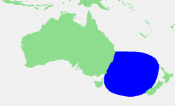
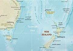
The Tasman Sea (Māori: Te Tai-o-Rehua[1], Pitcairn-Norfolk: Tasman Sii) is a marginal sea of the South Pacific Ocean, situated between Australia and New Zealand. It measures about 2,000 km (1,200 mi) across and about 2,800 km (1,700 mi) from north to south. The sea was named after the Dutch explorer Abel Janszoon Tasman, who was the first recorded European to encounter New Zealand and Tasmania. British explorer Captain James Cook later extensively navigated the Tasman Sea in the 1770s as part of his first voyage of exploration.[2]
| Tasman Sea | |
|---|---|
 Location | |
 Map of the Tasman Sea | |
| Location | Western Pacific Ocean |
| Coordinates | 40°S 160°E |
| Type | Sea |
| Basin countries | Australia, New Zealand |
| Max. length | 2,800 km (1,700 mi) |
| Max. width | 2,200 km (1,400 mi) |
| Surface area | 2,300,000 km2 (890,000 sq mi) |
| Islands | Lord Howe Island, Norfolk Island |
| Benches | Lord Howe Rise |
| Settlements | Newcastle, Sydney, Wollongong, Auckland, Wellington, Hobart, New Plymouth, Whanganui |
The Tasman Sea is informally referred to in both Australian and New Zealand English as the Ditch; for example, crossing the Ditch means travelling to Australia from New Zealand, or vice versa. The diminutive term "the Ditch" used for the Tasman Sea is comparable to referring to the North Atlantic Ocean as "the Pond".
Climate
The south of the sea is passed over by depressions going from west to east. The northern limit of these westerly winds is near to 40°S. During the southern winter, from April to October, the northern branch of these winds from the west changes its direction toward the north and goes up against trade winds. Hence, the sea receives frequent winds from the southwest during this period. In the Australian summer (from November to March), the southern branch of the trade winds goes up against west winds and produces further wind activity in the area.[3]
Geography
The Tasman Sea is 2,250 km (1,400 mi) wide and has an area of 2,300,000 km (1,400,000 mi).[2] The depth of the sea is 5,493 m (18,022 ft).[4] The base of the sea is made up of globigerina ooze. A small zone of pteropod ooze is found to the south of New Caledonia and to the southern extent of 30°S, siliceous ooze can be found.[5]
Extent
The International Hydrographic Organization defines the limits of the Tasman Sea as:[6]
On the West A line from Gabo Island (near Cape Howe, 37°30'S) to the northeast point of East Sister Island (148°E), thence along the 148th meridian to Flinders Island; beyond this island a line running to the eastward of the Vansittart Shoals to [Cape] Barren Island, and from Cape Barren (the easternmost point of [Cape] Barren Island) to Eddystone Point (41°S) in Tasmania, thence along the east coast to South East Cape, the southern point of Tasmania.
On the North The parallel of 30°S from the Australian coast eastward as far as a line joining the east extremities of Elizabeth Reef and South East Rock (31°47′S 159°18′E) then to the southward along this line to the South East Rock [an outlier of Lord Howe Island].
On the Northeast From the South East Rock to the north point of Three Kings Islands (34°10′S 172°10′E), thence to North Cape in New Zealand.
On the East
- In Cook Strait. A line joining the south extreme of the foul ground off Cape Palliser (Ngawi) and the Lighthouse on Cape Campbell (Te Karaka).
- In Foveaux Strait (46°45'S). A line joining the light on Waipapapa Point [sic] (168°33'E) with East Head (47'02'S) of Stewart Island (Rakiura).
On the Southeast A line running from South West Cape, Stewart Island, through the Snares (48°S, 166°30'E) to North West Cape, Auckland Island (50°30′S 166°10′E), through this island to its southern point.
On the South A line joining the southern point of Auckland Island (50°55′S 166°0′E) to South East Cape, the southern point of Tasmania.
Ridge
The Tasman Sea's midocean ridge developed between 85 and 55 million years ago as Australia and Zealandia broke apart during the breakup of supercontinent Gondwana. It lies roughly midway between the continental margins of Australia and Zealandia. Much of Zealandia is submerged, so the ridge runs much closer to the Australian coast than New Zealand's.[7]
Islands
The Tasman Sea features a number of midsea island groups, quite apart from coastal islands located near the Australian and New Zealand mainlands:
- Lord Howe Island (part of New South Wales)[8]
- Ball's Pyramid (part of New South Wales)[9]
Adjoining bodies of water
- North: Coral Sea[10]
- Northeast and East: Pacific Ocean
- East: Cook Strait
- South and southeast: Southern Ocean
- West: Bass Strait[11]
Animal and plant life
A deep-sea research ship, the RV Tangaroa, explored the sea and found 500 species of fish and 1300 species of invertebrates. The tooth of a megalodon, an extinct shark, was also found by researchers.[12]
History
Moncrieff and Hood were the first to attempt a trans-Tasman crossing by plane in 1928. The first successful flight over the sea was accomplished by Charles Kingsford Smith later that year. The first person to row solo across the sea was Colin Quincey in 1977. The next successful solo crossing was completed by his son, Shaun Quincey, in 2010.[13]
See also
References
- Rāwiri Taonui. Tapa whenua – naming places – Events, maps and European influences, Te Ara – the Encyclopedia of New Zealand, Ministry for Culture and Heritage. ISBN 978-0-478-18451-8. Updated 1 March 2009. Retrieved 24 February 2011
- "Tasman Sea". Encyclopædia Britannica. Retrieved 3 January 2018.
- Rotschi & Lemasson 1967, p. 54.
- "Depth of the sea" (PDF). Retrieved 23 April 2018.
- Rotschi & Lemasson 1967, p. 51.
- "Limits of Oceans and Seas, 3rd edition" (PDF). International Hydrographic Organization. 1953. p. 36. Retrieved 23 September 2016.
- Van Der Linden, Willem J.M (1969). "Extinct mid-ocean ridges in the Tasman sea and in the Western Pacific". Earth and Planetary Science Letters. 6 (6): 483–490. Bibcode:1969E&PSL...6..483V. doi:10.1016/0012-821X(69)90120-4.
- "Lord Howe Island, Tasman Sea, Australia". volcano.oregonstate.edu. Retrieved 23 April 2018.
- "Ball's Pyramid". Unusual Places. 5 September 2013. Retrieved 23 April 2018.
- van der Linden, Willem J. M. (January 2012). "Morphology of the Tasman sea floor". New Zealand Journal of Geology and Geophysics. 13 (1): 282–291. doi:10.1080/00288306.1970.10428218.
- "Mysterious ocean feature found in Tasman Sea". Australian Geographic. 24 February 2012. Retrieved 23 April 2018.
- "Tasman Sea produces freaky species". CBC News. 30 June 2003. Retrieved 23 April 2018.
- Anne Barrowclough (14 March 2010). "Kiwi becomes second person to row across the Tasman Sea". Times Online. Times Newspapers. Retrieved 22 May 2011.
Further reading
- Rotschi, H.; Lemasson, L. (1967), Oceanography of the Coral and Tasman Seas (PDF), Oceanogr Marine Biol Ann Rev, ASIN B00KJ0X6D4
External links
