Marquesas Islands
The Marquesas Islands (/mɑːrˈkeɪsəs/; French: Îles Marquises or Archipel des Marquises or Marquises; Marquesan: Te Henua ʻEnana (North Marquesan) and Te Fenua ʻEnata (South Marquesan), both meaning "the land of men") are a group of volcanic islands in French Polynesia, an overseas collectivity of France in the southern Pacific Ocean. The Marquesas are located at 9.7812° S, 139.0817° W. The highest point is the peak of Mount Oave (French: Mont Oave) on Ua Pou island at 1,230 m (4,035 ft) above sea level.[3]
| Native name: | |
|---|---|
 | |
 | |
| Geography | |
| Location | Pacific Ocean |
| Coordinates | 9°27′S 139°23′W |
| Archipelago | Polynesia |
| Total islands | 15 |
| Major islands | Nuku Hiva, Ua Pou, Ua Huka, Hiva ʻOa, Fatu Hiva, Tahuata |
| Area | 1,049.3 km2 (405.1 sq mi)[1] |
| Highest elevation | 1,230 m (4,040 ft) |
| Highest point | Mount Oave (Ua Pou) |
| Administration | |
| Collectivity | |
| Largest settlement | Taiohae (pop. 2,183 (2017[2])) |
| Demographics | |
| Population | 9,346 (2017[2]) |
| Pop. density | 8.9/km2 (23.1/sq mi) |
| Languages | French, Marquesan |
| Additional information | |
| Time zone | |
Archaeological research suggests the islands were colonized sometime after the 9th century and before the 11th century AD by indigenous voyagers from West Polynesia.[4] Over the course of subsequent centuries, these settlers developed a "remarkably uniform culture, human biology and language."[5]
The Marquesas Islands form one of the five administrative divisions (subdivisions administratives) of French Polynesia. The capital of the Marquesas Islands administrative subdivision is the town of Taiohae, on the island of Nuku Hiva. The population of the Marquesas Islands was 9,346 inhabitants at the time of the August 2017 census.[2]
Geography
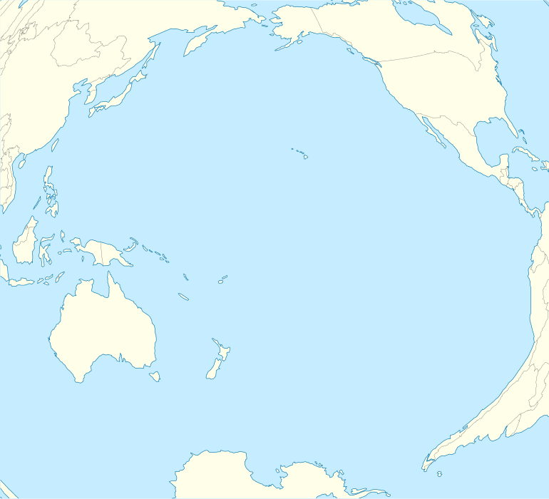
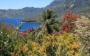
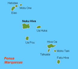
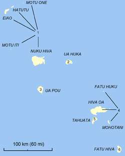
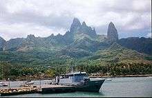
The Marquesas Islands group is one of the most remote in the world, lying about 852 mi (1,370 km) northeast of Tahiti and about 3,000 mi (4,800 km) away from the west coast of Mexico, the nearest continental land mass. They fall naturally into two geographical divisions: the northern group, consisting of Eiao, Hatutu (Hatutaa), Motu One, and the islands centered on the large island of Nuku Hiva: Motu Iti (Hatu Iti), Ua Pou, Motu Oa and Ua Huka, and the southern group of Fatu Uku, Tahuata, Moho Tani (Motane), Terihi, Fatu Hiva and Motu Nao (Thomasset Rock), clustered around the main island of Hiva ʻOa. With a combined land area of 1,049 square kilometres (405 sq mi), the Marquesas are among the largest island groups of French Polynesia the Spanish galleons fleets arrived at en route to Manila, Nuku Hiva being the second largest island in the entire territory, after Tahiti. With the exception of Motu One, all the islands of the Marquesas are of volcanic origin.
In contrast to the tendency to associate Polynesia with lush tropical vegetation, the Marquesas are remarkably dry islands. Though the islands lie within the tropics, they are the first major break in the prevailing easterly winds that spawn from the extraordinarily dry (from an atmospheric perspective) Humboldt Current. Because of this, the islands are subject to frequent drought conditions, and only those that reach highest into the clouds (generally, above about 750 m / 2,500 ft above sea level) have reliable precipitation. This has led to historical fluctuations in water supply, which have played a crucial role in the sustainability of human populations in certain sections of the various islands throughout the archipelago. This is especially evident in the low historical population of Ua Huka (maximum elevation 857 m m / 2,812 ft.) and the intermittent inhabitability of Eiao (maximum elevation 576 m m / 1,890 ft.). The Marquesas Islands are thought to have formed by a center of upwelling magma called the Marquesas hotspot.[6]
Islands of the Marquesas
Northern Marquesas
Seamounts
There are also a number of seamounts or shoals, located primarily in the area of the northern Marquesas. Among these are:
- Clark Bank
- Hinakura Bank
- Lawson Bank
- Bank Jean Goguel
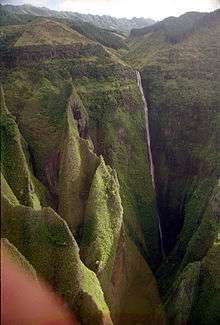
Geology
.jpg)
The bulk of the Marquesas Islands are of volcanic origin, created by the Marquesas hotspot that underlies the Pacific Plate. The Marquesas Islands lie above a submarine volcanic plateau of the same name. The plateau, like the islands, is generally believed to be less than 5 million years old, though one hypothesis has the plateau (not the islands) as significantly older and having a mirror image, the Inca Plateau, subducting under northern Peru.[7]
Except for Motu One, all the Marquesas are high islands. Motu One is a low island, comprising two small sand banks awash on a coral reef. Unlike the majority of French Polynesian islands, the Marquesas are not surrounded by protective fringing reefs.[8] Except for Motu One, and in bays and other protected areas, the only other coral in the Marquesas is found in a rather strange place: on the top of the island of Fatu Huku. The South Equatorial Current lashes the islands mercilessly, which has led to sea-caves dotting the islands' shores. Except for where the valleys empty into the small bays, the islands are remarkable for their mountain ridges, which end abruptly as cliffs where they meet the sea. The islands are estimated to range in age from the youngest, Fatu Hiva (1.3 million years) to the oldest, Eiao (6 million years).
Climate
Temperatures in the Marquesas are stable year around, but precipitation is highly variable. Precipitation is much greater on the north and east (windward) parts of the islands than on the western (leeward) parts. Average annual precipitation can vary from more than 100 inches (2,500 mm) on windward shores and mountains to a low as 20 inches (510 mm) in the "desert" region of Nuku Hiva. Droughts, sometimes lasting several years, are frequent and seem to be associated with the El Niño phenomena.[9] The statistics from the weather station at Atuona on Hiva ʻOa is representative of the average sea-level climate of the Marquesas. Illustrating the variability of precipitation, the highest annual rainfall recorded in Atuona is 148.2 inches (3,760 mm); the lowest is 22 inches (560 mm).[10]
| Climate data for Atuona, Hiva ʻOa | |||||||||||||
|---|---|---|---|---|---|---|---|---|---|---|---|---|---|
| Month | Jan | Feb | Mar | Apr | May | Jun | Jul | Aug | Sep | Oct | Nov | Dec | Year |
| Average high °C (°F) | 30 (86) |
31 (87) |
31 (87) |
31 (87) |
29 (85) |
29 (84) |
28 (83) |
28 (83) |
29 (84) |
29 (85) |
30 (86) |
30 (86) |
29 (85) |
| Daily mean °C (°F) | 27 (81) |
27 (81) |
28 (82) |
28 (82) |
27 (80) |
26 (79) |
26 (78) |
26 (78) |
26 (79) |
26 (79) |
27 (80) |
27 (81) |
27 (80) |
| Average low °C (°F) | 23 (74) |
24 (75) |
24 (76) |
24 (76) |
24 (75) |
23 (74) |
23 (74) |
23 (73) |
23 (73) |
23 (73) |
23 (74) |
23 (74) |
23 (74) |
| Average precipitation mm (inches) | 110 (4.5) |
91 (3.6) |
140 (5.4) |
120 (4.6) |
120 (4.8) |
180 (6.9) |
120 (4.8) |
100 (4) |
81 (3.2) |
79 (3.1) |
66 (2.6) |
89 (3.5) |
1,290 (50.9) |
| Source: Weatherbase[11] | |||||||||||||
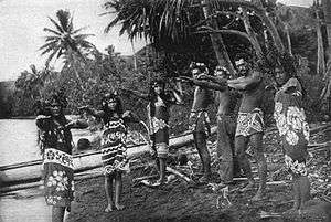
History
%2C_19th_century..jpg)
The first recorded settlers of the Marquesas were Polynesians who arrived from West Polynesia. Initially, the carbon-dating evidence suggested their arrival before AD 100 but the date of initial colonization has since been brought forward in many independent dating studies.
For example, a 2010 study using revised, high-precision radiocarbon dating based on more reliable samples, suggests that the period of eastern Polynesian colonization took place much later, in a shorter time frame of two waves: the "earliest in the Society Islands A.D. ∼1025–1120, four centuries later than previously assumed; then after 70–265 years, dispersal continued in one major pulse to all remaining islands A.D. ∼1190–1290."[5] This rapid colonization is believed to account for the "remarkable uniformity of East Polynesia culture, biology and language."[5]
In 2014, the date of first settlement for the Marquesas was pushed back slightly to around AD 900–1000.[12][13]
Historical culture
The rich environment of the islands supported a large population that lived by fishing, collecting shellfish, hunting birds and gardening. They relied heavily on breadfruit but raised at least 32 other introduced crops. Hard evidence of significant pre-European interarchipelago trade has been found in basalt from the Marquesan quarry island of Eiao that is known to have been distributed aboard sailing canoes over immense distances of up to 2500 km and more to provide adze heads on Mo'orea (Society Islands), Mangareva (Gambier Islands), Tubuai (Austral Islands), Rarotonga (Cook Islands), and Tabuaeran (Northern Line Islands).[14]
European contact
The first Europeans to reach the Marquesas may have been the crew of San Lesmes, a Spanish vessel which disappeared in a storm in June 1526; it was part of an expedition headed by García Jofre de Loaísa.[15] The Spanish explorer Álvaro de Mendaña reached them nearly seventy years later on 21 July 1595. He named them after his patron, García Hurtado de Mendoza, 5th Marquis of Cañete (Spanish: Marqués de Cañete), who served as Viceroy of Peru from 1590 to 1596. Mendaña visited first Fatu Hiva and then Tahuata before continuing on to the Solomon Islands. His expedition charted the four southernmost Marquesas as Magdalena (Fatu Hiva), Dominica (Hiva ʻOa), San Pedro (Moho Tani), and Santa Cristina (Tahuata).[16]
In the late 16th century European explorers estimated the population at more than 100,000. Europeans and Americans were impressed with how easy life appeared to be in the islands, which had a rich habitat and environment. In 1791 the American maritime fur trader Joseph Ingraham first visited the northern Marquesas while commanding the brig Hope. He named them the Washington Islands.[17] In 1813 Commodore David Porter claimed Nuku Hiva for the United States, but the United States Congress never ratified that claim.
The islands were a popular port of call for visiting whaling ships in the Age of Sail. The first on record was the Hope in April 1791.[18] The last known such visitor was the American whaler Alaska in February 1907.[19]
In 1842 France conducted a successful military operation on behalf of the native chief Iotete, who claimed he was king of the whole island of Tahuata. The government laid claim to the whole group and established a settlement on Nuku Hiva. That settlement was abandoned in 1857, but France re-established control over the group in 1870. It later incorporated the Marquesas into French Polynesia.
Of all major island groups in the Pacific, the Marquesas suffered the greatest population decline in Polynesia from endemic diseases carried by Western explorers. The indigenous people suffered high rates of mortality, as they had no immunity to the new diseases. Such infectious diseases as smallpox, measles and others reduced the eighteenth-century population of over 78,000 inhabitants to about 20,000 by the middle of the nineteenth century. By the turn of the 20th century, the islands' population had reduced to just over 4,000.[20] During the course of the twentieth century, after reaching a nadir of 2,255 in 1926, the population finally started to increase, reaching 8,548 at the November 2002 census,[21] not including the Marquesan community residing on Tahiti. It has continued to increase, reaching 9,346 inhabitants at the August 2017 census.[2]
Government and politics
The Marquesas Islands form one of the five administrative divisions (subdivisions administratives) of French Polynesia. French and Tahitian are the official languages of government. The capital of the Marquesas Islands administrative subdivision is the settlement of Taiohae on the island of Nuku Hiva.
The sparsely populated Marquesas Islands are located 1,371 km (852 mi) from Tahiti. With 183,645 inhabitants (2012 census), Tahiti is the most populous island of French Polynesia, containing 68.5% of the total population of the grouping.[22]
Residents of the Marquesas have chafed at Tahiti's overwhelming dominance, complaining of neglect by politicians based in Tahiti, and leaders have suggested developing a direct relationship with the metropole, the government in Paris, instead of depending on Papeete.[23] As sentiment was rising in Tahiti in the 21st century for independence from France, several prominent Marquesan political leaders in 2007 floated the idea of the Marquesas Islands separating from French Polynesia but remaining within the French Republic.[23] This has generated controversies in Tahiti, where pro-independence Tahitian leaders have accused the French central government of encouraging the separation of the Marquesas Islands from French Polynesia.[23]
Administration
The Marquesas Islands do not have a provincial or regional assembly. Administratively, they form a deconcentrated subdivision of both the French central State and the government of French Polynesia. As a deconcentrated subdivision of the French central State, the Marquesas Islands form the administrative subdivision of the Marquesas (French: subdivision administrative des Marquises), one of French Polynesia's five administrative subdivisions. The head of the administrative subdivision of the Marquesas is the administrateur d'État ("State administrator"), generally simply known as administrateur, also sometimes called chef de la subdivision administrative ("head of the administrative subdivision"). The administrateur is a civil servant under the authority of the High Commissioner of the French Republic in French Polynesia in Papeete. The administrateur and his staff sit in Taiohae, on the island of Nuku Hiva, which has become the administrative capital of the Marquesas Islands, having replaced Atuona on the island of Hiva ʻOa, which was previously the capital.
Acting as the representative of the French central State and delegate of Papeete's High Commissioner, the administrateur of the Marquesas is in charge of:
- Offering legal advice to the communes (municipalities) of the Marquesas and verifying the legality of decisions made by the communes
- Issuing official documents (ID cards, driving licences, etc.), applying immigration rules, organising elections
- Managing security (coordination of gendarmerie forces, handling of major crises such as natural disasters, etc.)
- Overseeing public services of the French central State in the Marquesas Islands (such as the correctional facility on Nuku Hiva)
As a deconcentrated subdivision of the government of French Polynesia, the Marquesas Islands form the circonscription des Marquises ("district of the Marquesas"), one of French Polynesia's four circonscriptions ("districts") created in 2000 by the Assembly of French Polynesia to serve as deconcentrated subdivisions of the government of French Polynesia in the islands away from Tahiti and Moorea. The head of the circonscription des Marquises is the tavana hau, known as administrateur territorial in French ("territorial administrator"), but the Tahitian title tavana hau is most often used. The tavana hau is the direct representative of the president of French Polynesia's government who appoints him. The tavana hau and his staff sit in Taiohae on Nuku Hiva, same as the State administrator.
The tavana hau is in charge of:
- Coordinating the work of French Polynesian administrations in the Marquesas Islands (such as the French Polynesian administrations in charge of roads, fisheries, etc.)
- Ensuring the enforcement of acts passed by the Assembly of French Polynesia and decisions taken by the government of French Polynesia
- Evaluating the performance of French Polynesian civil servants and sending the evaluations to the responsible ministries in Papeete
- Acting as a liaison between the local population and the government of French Polynesia in Papeete
The Marquesas Islands also form the electoral district of the Marquesas Islands, one of French Polynesia's six electoral districts for the Assembly of French Polynesia (see also Politics of French Polynesia).
The Marquesas Islands are subdivided in six communes (municipalities). In each of the six communes the local residents elect a municipal council and a mayor in charge of managing local affairs within the commune. Three communes (Nuku-Hiva, Ua-Pou, and Hiva-Oa) are further subdivided into associated communes due to their larger population. The communes and associated communes are the only elected councils in the Marquesas since there does not exist a provincial or regional assembly for the entire archipelago. Municipal elections are held every six years on the same day as municipal elections in the rest of France (see 2014 French municipal elections for the last municipal elections).
The areas and populations of the communes at the 2012 Census were as follows:
Demographics
Historical population
| 1799 | 1853 | 1863 | 1872 | 1883 | 1892 | 1902 | 1911 | 1921 | 1926 | 1931 | 1936 | |
|---|---|---|---|---|---|---|---|---|---|---|---|---|
| 50,000 to 100,000 | 11,900 | 8,650 | 6,045 | 5,576 | 4,445 | 3,963 | 3,116 | 2,300 | 2,255 | 2,283 | 2,400 | |
| 1946 | 1956 | 1962 | 1971 | 1977 | 1983 | 1988 | 1996 | 2002 | 2007 | 2012 | 2017 | |
| 2,976 | 4,165 | 4,838 | 5,593 | 5,419 | 6,548 | 7,358 | 8,064 | 8,548 | 8,632 | 9,264 | 9,346 | |
| Past estimates and official figures from past censuses.[2][21][24][25][26][27] | ||||||||||||
Migrations
The places of birth of the 9,346 residents of the Marquesas Islands at the 2017 census were the following:[28]
- 63.2% were born in the Marquesas Islands (down from 70.5% at the 2007 census)
- 29.2% in Tahiti (up from 20.9% at the 2007 census)
- 4.0% in Metropolitan France (down from 4.5% at the 2007 census)
- 2.5% in French Polynesia (other than the Marquesas Islands and Tahiti) (down from 3.0% at the 2007 census)
- 0.8% in foreign countries (up from 0.6% at the 2007 census)
- 0.3% in the overseas departments and territories of France (other than French Polynesia) (down from 0.5% at the 2007 census)
Between the 2007 and 2017 censuses, the population of residents of the Marquesas Islands born in Tahiti rose by 50.5% (from 1,810 at the 2007 census to 2,726 at the 2017), and as a result, they made up 29.2% of the population in 2017. A lot of these arrivals from Tahiti, however, are children of Marquesans who had migrated to Tahiti and given birth there, and whose children are returning to the Marquesas, as can be seen in the language statistics: 50.8% of the Marquesas Islands' residents whose age was 15 or older and who were born in Tahiti and lived in the Marquesas at the 2017 census reported that the language they spoke the most at home was Marquesan, whereas 42.1% reported French, and only 6.6% reported Tahitian.[29]
3,353 people born in the Marquesas Islands lived on the island of Tahiti at the 2017 census (down from 3,493 at the 2007 census), whereas 5,907 people born in the Marquesas Islands lived in the Marquesas (down from 6,106 at the 2007 census), and 705 lived in the rest of French Polynesia (up from 679 at the 2007 census).[28][30] The total number of people born in the Marquesas Islands and living in French Polynesia decreased from 10,278 at the 2007 census to 9,965 at the 2017 census, as net births were not able to offset the departures to New Caledonia and Metropolitan France due to the economic crisis experienced by French Polynesia.
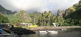
Language
.JPG)
French and Tahitian are the only official languages of all of French Polynesia, but the Marquesan languages, in their various forms, remain the primary means of communication among residents within this archipelago, although knowledge of French is now almost universal among residents of the Marquesas Islands (see census data below).
Marquesan is a collection of East-Central Polynesian dialects, of the Marquesic group, spoken in the Marquesas Islands of French Polynesia. They are usually classified into two groups, North Marquesan and South Marquesan, corresponding roughly along geographic lines.
The North Marquesan dialects are spoken on the islands of Ua Pu and Nuku Hiva, and South Marquesan dialects on the islands of Hiva ʻOa, Tahuata and Fatu Hiva. The dialects of Ua Huka are often incorrectly classified as North Marquesan; they are instead transitional. While the island is in the northern Marquesas group, the dialects show more morphological and phonological affinities with South Marquesan. The North Marquesan dialects are sometimes considered to be two separate languages: North Marquesan and Tai Pi Marquesan, the latter being spoken in the valleys of the eastern third of the island of Nuku Hiva, in the ancient province of Tai Pi.
The most striking feature of the Marquesan languages is their almost universal replacement of the /r/ or /l/ of other Polynesian languages by a /ʔ/ (glottal stop).
Like other Polynesian languages, the phonology of Marquesan languages is characterised by a paucity of consonants and a comparative abundance of vowels.
Language data in 2017 census
At the 2017 census, 97.0% of the population whose age was 15 and older reported that they could speak French (up from 94.1% at the 2007 census). 92.6% reported that they could also read and write it (up from 90.2% at the 2007 census). Only 1.9% of the population whose age was 15 and older had no knowledge of French (down from 4.4% at the 2007 census).[29][31]
At the same census, 66.9% of the population whose age was 15 and older reported that the language they spoke the most at home was Marquesan (down from 67.8% at the 2007 census). 30.2% reported that French was the language they spoke the most at home (up from 30.1% at the 2007 census). 2.3% reported Tahitian (up from 1.4% at the 2007 census), and 0.6% reported another language (down from 0.7% at the 2007 census).[29][32]
4.9% of the population whose age was 15 and older reported that they had no knowledge of any Polynesian language at the 2017 census (down from 7.2% at the 2007 census).[29][31]
Communications
Airports
There are four airports in the Marquesas, one each on the islands of Nuku Hiva, Ua Pu, Ua Huka, and Hiva ʻOa. The terrain of Tahuata is too irregular to allow for the construction of a landing strip without significant investment, and while the upland plateau of central Fatu Hiva is large enough to permit the construction of an airstrip, the island's minuscule population makes such an exercise of dubious benefit.
Telecommunications
The Marquesas are served by telephone as well as by radio and television, mainly from Tahiti. Recent additions include the "Vini" a mobile phone service that, in about 6 years, has expanded to cover most of the populated islands. There also is "Mana", an internet server with DSL broadband that is expanding with Wi-Fi stations too.

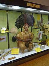
Culture
The Marquesas Islands were once a major center of eastern Polynesian civilization. Wooden and stone crafts and tattooing are common practices among the locals.
Biology
The ecosystem of the Marquesas has been devastated in some areas by the activities of feral livestock. As a first step in preserving what remains, the Marquesan Nature Reserves were created in 1992.
See also
- Administrative divisions of France
- List of French islands in the Indian and Pacific oceans
- Overseas departments and territories of France
- Politics of French Polynesia
- Survivor: Marquesas
References
- "R1- Population sans doubles comptes, des subdivisions, communes et communes associées de Polynésie française, de 1971 à 1996". ISPF. Archived from the original on 14 November 2012. Retrieved 13 October 2013.
- "Population". Institut de la statistique de la Polynésie française (in French). Retrieved 7 June 2019.
- Communes des Îles Marquises Archived 9 December 2008 at the Wayback Machine
- Allen, Melinda S. and McAlister, Andrew J., 2010, "The Hakaea Beach Site, Marquesan colonisation, and Models of East Polynesian Settlement" Archaeology in Oceania, Vol. 45, p. 54-65.
- Janet M. Wilmshurst, Terry L. Hunt, Carl P. Lipo, and Atholl J. Anderson. "High-precision radiocarbon dating shows recent and rapid initial human colonization of East Polynesia" Archived 24 September 2015 at the Wayback Machine, PNAS, vol. 108 no. 5, doi: 10.1073/pnas.1015876108, accessed 26 October 2015
- Desonie, D. L.; Duncan, R. A.; Natland, J. H. (10 October 1993). "Temporal and geochemical variability of volcanic products of the Marquesas Hotspot". Journal of Geophysical Research: Solid Earth. 98 (B10): 17649–17665. doi:10.1029/93JB01562. ISSN 2156-2202.
- The "lost Inca Plateau": cause of flat subduction beneath Peru? Archived 3 July 2010 at Wikiwix, 1999
- "Papeete measures 5 small waves during tsunami red alert". Tahitipresse. 29 September 2009. Archived from the original on 3 October 2009. Retrieved 30 September 2009.
- Addison, David J. "Traditional Agriculture of the Marquesas Islands (French Polynesia)" Rapa Nui Journal 21.2 (2007): 111-27.
- Florence, Jacques and Lorence, David H. "Introduction to the Flora and Vegetation of the Marquesas Islands" Allertonia, Vol. 7, No. 4, p. 223
- "Weatherbase: Historical Weather for Atuona, French Polynesia". Weatherbase. 2011. Archived from the original on 7 December 2013. Retrieved 24 November 2011.
- Allen, Melinda S. (2014). "Marquesan colonisation chronologies and post-colonisation Interaction: Implications for Hawaiian origins and the 'Marquesan Homeland' hypothesis". J. Pac. Archaeol. 5 (2): 1–17.
- Conte, Eric (2014). "Reinvestigating a key site for Polynesian prehistory: new results from the Hane dune site, Ua Huka (Marquesas)". Archaeology in Oceania. 49 (3): 121–136. doi:10.1002/arco.5037.
- Crowe, Andrew (2018). Pathway of the Birds: The Voyaging Achievements of Māori and their Polynesian Ancestors. Auckland, New Zealand: Bateman. ISBN 9781869539610.
- Berguno, Jorge (1990). Hardy, John; Frost, Alan (eds.). European Voyaging towards Australia. Australian Academy of the Humanities. p. 25. ISBN 978-0909897192.
- Sharp, Andrew, The Discovery of the Pacific Islands, Oxford 1960 p. 51
- "Papers of Joseph Ingraham, 1790-1792: Journal of the Voyage of the Brigantine Hope from Boston to the North-West Coast of America". World Digital Library. 1790–1800. Archived from the original on 8 June 2013. Retrieved 8 June 2013.
- Langdon, Robert (1984), Where the whalers went: An index to the Pacific ports and islands visited by American whalers (and some other ships) in the 19th century, Canberra, Pacific Manuscripts Bureau, p.168 & 171. ISBN 086784471X
- Langdon, p.175
- Gille, Bernard; Toullelan, Pierre-Yves (1999). Au Vent des Iles (ed.). De la conquête à l'exode : histoire des Océaniens et de leurs migrations dans le Pacifique. p. 118. ISBN 978-2909790596.
- "Population statistique des communes et communes associées aux recensements de 1971 à 2002". ISPF. Archived from the original on 13 November 2012. Retrieved 13 October 2013.
- Chart of the Island Otaheite, by Lieut. J. Cook 1769 Archived 8 December 2010 at the Wayback Machine. National Maritime Museum. nmm.ac.uk
- Polémique à Tahiti: les Marquises veulent se rapprocher de Paris Archived 2 March 2008 at the Wayback Machine, Rue 89, 23 December 2007
- INSEE. "Population des subdivisions administratives de Polynésie française au RP 2007" (in French). Archived from the original on 24 September 2015. Retrieved 13 October 2013.
- Journal de la Société des océanistes. "A propos des résultats statistiques du Recensement de 1962 en Polynésie Française" (PDF) (in French). Archived (PDF) from the original on 23 March 2013. Retrieved 6 January 2018.
- INSEE. "Population des subdivisions administratives de Polynésie française" (in French). Archived from the original on 7 January 2013. Retrieved 13 October 2013.
- "Intégralité des évaluations et des recensements de population aux Îles Marquises" (in French). Retrieved 6 January 2018.
- "Recensements de la population > 2017 > Données détaillées > Migrations". ISPF. Retrieved 24 November 2019.
- "Recensements de la population > 2017 > Données détaillées > Langues". ISPF. Retrieved 24 November 2019.
- "Recensements de la population > 2007 > Données détaillées > Migrations". ISPF. Retrieved 24 November 2019.
- "LAN3b - Population de 15 ans et plus par connaissance des langues selon la subdivision de résidence et l'âge décennal". ISPF. Archived from the original on 13 November 2012. Retrieved 13 October 2013.
- "Recensements de la population > 2007 > Données détaillées > Langues". ISPF. Archived from the original on 13 November 2013. Retrieved 13 October 2013.
Further reading
- Kjellgren, Eric & Ivory, Carol S. (2005). Adorning the world: art of the Marquesas Islands. New York: The Metropolitan Museum of Art. ISBN 9781588391469.
- Urmenyhazi, Attila. 2013 book publication: "Samoan & Marquesan Life in Oceania: a probing travelogue". ISBN 9780646909127 - National Library of Australia, Bib ID: 6377055
External links
| Wikimedia Commons has media related to Marquesas Islands. |
- . Encyclopædia Britannica. 17 (11th ed.). 1911. pp. 750–751.
- Stevenson, Robert L. (1896), In the South Seas
- Official website Les îles Marquises en polynésie française
- Administrative divisions of the Marquesas Islands
- Effects of the 1946 Aleutian Tsunami on the Marquesas Is.
- Flora of the Marquesas Islands
- WorldAtlas.com's map of the Marquesas—includes most of the islands
- Sailing Schedule to the Marquesas Islands
| History |
|  | |
|---|---|---|---|
| Geography |
| ||
| Politics | |||
| Economy | |||
| Culture |
| ||
| Northern Marquesas: | |||
|---|---|---|---|
| Southern Marquesas: | |||