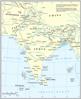
South Asia
South Asia or Southern Asia is the southern region of Asia, which is defined in both geographical and ethno-cultural terms. The region consists of Afghanistan, Bangladesh, Bhutan, India, Maldives, Nepal, Pakistan, and Sri Lanka.[5][note 2] Topographically, it is dominated by the Indian Plate and defined largely by the Indian Ocean on the south, and the Himalayas, Karakoram, and Pamir mountains on the north. The Amu Darya, which rises north of the Hindu Kush, forms part of the northwestern border. On land (clockwise), South Asia is bounded by Western Asia, Central Asia, East Asia, and Southeast Asia.
_without_national_boundaries.svg.png) | |
| Area | 5,134,641 km2 (1,982,496 sq mi) |
|---|---|
| Population | 1,814,014,121 (2018) (1st)[1][2] |
| Population density | 362.3/km2 (938/sq mi) |
| GDP (PPP) | $12.752 trillion (2018)[3] |
| GDP (nominal) | $3.461 trillion (2018)[3] |
| GDP per capita | $1,908 (nominal)[3] $7,029 (PPP)[3] |
| HDI | |
| Ethnic groups | Indo-Aryan, Iranian, Dravidian, Sino-Tibetan, Austroasiatic, etc. |
| Religions | Hinduism, Islam, Christianity, Buddhism, Sikhism, Jainism, Zoroastrianism |
| Demonym | South Asian Desi (colloquial) |
| Countries | |
| Dependencies | |
| Languages | Official languages
Other languages
|
| Time zones | |
| Internet TLD | .af, .bd, .bt, .in, .lk, .mv, .np, .pk |
| Calling code | Zone 8 & 9 |
| Largest cities | [note 1] |
| UN M49 code | 034 – Southern Asia142 – Asia001 – World |
The South Asian Association for Regional Cooperation (SAARC) is an economic cooperation organisation in the region which was established in 1985 and includes all eight nations comprising South Asia.[7] South Asia covers about 5.2 million km2 (2.0 million sq mi), which is 11.71% of the Asian continent or 3.5% of the world's land surface area.[5] The population of South Asia is about 1.891 billion or about one-fourth of the world's population, making it both the most populous and the most densely populated geographical region in the world.[8] Overall, it accounts for about 39.49% of Asia's population, over 24% of the world's population, and is home to a vast array of people.[9][10][11]
In 2010, South Asia had the world's largest populations of Hindus, Muslims, Sikhs, Jains and Zoroastrians.[12] South Asia alone accounts for 98.47% population of global Hindus, 90.5% of global Sikhs, 31% of global Muslims, 35 million Christians and 25 million Buddhists.[13][14][15][16]
Definition
update.PNG)
Modern definitions of South Asia are consistent in including Afghanistan, India, Pakistan, Bangladesh, Sri Lanka, Nepal, Bhutan and Maldives as the constituent countries.[18][19][20][21][22][23] Afghanistan is, however, considered by some to be a part of Central Asia, Western Asia, or the Middle East.[24][25][26][27] After the Second Anglo-Afghan War, it was a British protectorate until 1919.[20][21][23] On the other hand, Myanmar (formerly Burma), administered as part of the British Raj between 1886 and 1937[28] and now largely considered a part of Southeast Asia as a member state of ASEAN, is also sometimes included.[24][25][29] But the Aden Colony, British Somaliland and Singapore, though administered at various times under the British Raj, have never been proposed as any part of South Asia.[30] The region may also include the disputed territory of Aksai Chin, which was part of the British Indian princely state of Jammu and Kashmir, now administered as part of the Chinese autonomous region of Xinjiang but also claimed by India.[31]
However, the total area of South Asia and its geographical extent is not clear cut as systemic and foreign policy orientations of its constituents are quite asymmetrical.[24] Beyond the core territories of the British Raj or the British Indian Empire, there is a high degree of variation as to which other countries are included in South Asia.[32][25][33][34] The confusion existed also because of the lack of a clear boundary – geographically, geopolitical, socio-culturally, economically or historically – between South Asia and other parts of Asia, especially the Middle East and Southeast Asia.[35]
The common definition of South Asia is largely inherited from the administrative boundaries of the British Raj,[36] with several exceptions. The current territories of Bangladesh, India, and Pakistan which were the core territories of the British Empire from 1857 to 1947 also form the core territories of South Asia.[18][19][22][23] The mountain countries of Nepal and Bhutan, two independent countries that were not part of the British Raj,[37] and the island countries of Sri Lanka and Maldives are generally included as well.
By various definitions based on substantially different reasons, the British Indian Ocean Territory and the Tibet Autonomous Region are included as well.[38][39][40][41][42][43][44] The 562 princely states that were protected by but not directly ruled by the British Raj became administrative parts of South Asia upon joining India or Pakistan.[45][46][47]
The South Asian Association for Regional Cooperation (SAARC), a contiguous block of countries, started in 1985 with seven countries – Bangladesh, Bhutan, India, the Maldives, Nepal, Pakistan and Sri Lanka – and admitted Afghanistan as an eighth member in 2007.[49][50] China and Myanmar have also applied for the status of full members of SAARC.[51][52] The South Asia Free Trade Agreement admitted Afghanistan in 2011.[53]
The World Bank amd United Nations Children's Fund (UNICEF) recognizes the eight SAARC countries as South Asia,[54][55][56][57] The Hirschman–Herfindahl index of the United Nations Economic and Social Commission for Asia and the Pacific for the region excludes Afghanistan from South Asia.[58] Population Information Network (POPIN) excludes Maldives which is included as a member Pacific POPIN subregional network.[59] The United Nations Statistics Division's scheme of sub-regions, for statistical purpose,[17] includes Iran along with all eight members of the SAARC as part of Southern Asia.[60]
The boundaries of South Asia vary based on how the region is defined. South Asia's northern, eastern, and western boundaries vary based on definitions used, while the Indian Ocean is the southern periphery. Most of this region rests on the Indian Plate and is isolated from the rest of Asia by mountain barriers.[61][62] Much of the region consists of a peninsula in south-central Asia, rather resembling a diamond which is delineated by the Himalayas on the north, the Hindu Kush in the west, and the Arakanese in the east,[63] and which extends southward into the Indian Ocean with the Arabian Sea to the southwest and the Bay of Bengal to the southeast.[38][64]
The terms "Indian subcontinent" and "South Asia" are sometimes used interchangeably.[38][66][64][67] The Indian subcontinent is largely a geological term referring to the land mass that drifted northeastwards from ancient Gondwana, colliding with the Eurasian plate nearly 55 million years ago, towards the end of Palaeocene. This geological region largely includes Bangladesh, Bhutan, India, Maldives, Nepal, Pakistan and Sri Lanka.[68] Historians Catherine Asher and Cynthia Talbot state that the term "Indian subcontinent" describes a natural physical landmass in South Asia that has been relatively isolated from the rest of Eurasia.[69]
The use of the term Indian subcontinent began in the British Empire, and has been a term particularly common in its successors.[66] South Asia as the preferred term is particularly common when scholars or officials seek to differentiate this region from East Asia.[70] According to historians Sugata Bose and Ayesha Jalal, the Indian subcontinent has come to be known as South Asia "in more recent and neutral parlance."[71] This "neutral" notion refers to the concerns of Pakistan and Bangladesh, particularly given the recurring conflicts between India and Pakistan, wherein the dominant placement of "India" as a prefix before the subcontinent might offend some political sentiments.[29] This region has also been labelled as "India" (in its classical and pre-modern sense) and "Greater India".[29][65]
According to Robert M. Cutler – a scholar of Political Science at Carleton University,[72] the terms South Asia, Southwest Asia, and Central Asia are distinct, but the confusion and disagreements have arisen due to the geopolitical movement to enlarge these regions into Greater South Asia, Greater Southwest Asia, and Greater Central Asia. The frontier of Greater South Asia, states Cutler, between 2001–2006 has been geopolitically extended to eastern Iran and western Afghanistan in the west, and in the north to northeastern Iran, northern Afghanistan, and southern Uzbekistan.[72]
The definitions are also varied across South Asian Study programmes. The Centre for South Asian Studies at the University of Cambridge was established, in 1964, it promoted the study of India, Pakistan, Sri Lanka, Bangladesh, Afghanistan,[73][74][75][76] the Himalayan Kingdoms (Nepal, Bhutan, and Sikkim[77]), and Burma (now Myanmar). It has since included Thailand, Malaysia, Singapore, Vietnam, Cambodia, Laos, Indonesia, the Philippines and Hong Kong.[78] The Centres for South Asian Studies at both the University of Michigan and the University of Virginia include Tibet along with the eight members of SAARC in their research programs, but exclude the Maldives.[79][80] The South Asian Studies Program of Rutgers University and the University of California, Berkeley Centre for South Asia Studies also include the Maldives.[81][82]
The South Asian Studies Program of Brandeis University defines the region as comprising "India, Pakistan, Bangladesh, Sri Lanka, Nepal, Bhutan, and in certain contexts Afghanistan, Burma, Maldives and Tibet".[83] The similar program of Columbia University includes Afghanistan, Bangladesh, India, the Maldives, Nepal, Pakistan, and Sri Lanka in their study and excludes Burma.[84] In the past, a lack of a coherent definition for South Asia resulted in a lack of academic studies, along with a lack of interest for such studies.[85] Identification with a South Asian identity was also found to be significantly low among respondents in an older two-year survey across Bangladesh, India, Nepal, Pakistan, and Sri Lanka.[86]
History
Pre-history
The history of core South Asia begins with evidence of human activity of Homo sapiens, as long as 75,000 years ago, or with earlier hominids including Homo erectus from about 500,000 years ago.[87] The earliest prehistoric culture have roots in the mesolithic sites as evidenced by the rock paintings of Bhimbetka rock shelters dating to a period of 30,000 BCE or older,[note 4] as well as neolithic times.[note 5]
Ancient era
The Indus Valley Civilization, which spread and flourished in the northwestern part of South Asia from c. 3300 to 1300 BCE in present-day Northern India, Pakistan and Afghanistan, was the first major civilization in South Asia.[88] A sophisticated and technologically advanced urban culture developed in the Mature Harappan period, from 2600 to 1900 BCE.[89] According to anthropologist Possehl, the Indus Valley Civilization provides a logical, if somewhat arbitrary, starting point for South Asian religions, but these links from the Indus religion to later-day South Asian traditions are subject to scholarly dispute.[90]
.jpg)
The Vedic period, named after the Vedic religion of the Indo-Aryans,[note 6] lasted from c. 1900 to 500 BCE.[92][93] The Indo-Aryans were pastoralists[94] who migrated into north-western India after the collapse of the Indus Valley Civilization,[91][95] Linguistic and archaeological data show a cultural change after 1500 BCE,[91] with the linguistic and religious data clearly showing links with Indo-European languages and religion.[96] By about 1200 BCE, the Vedic culture and agrarian lifestyle was established in the northwest and northern Gangetic plain of South Asia.[94][97][98] Rudimentary state-forms appeared, of which the Kuru-Pañcāla union was the most influential.[99][100] The first recorded state-level society in South Asia existed around 1000 BCE.[94] In this period, states Samuel, emerged the Brahmana and Aranyaka layers of Vedic texts, which merged into the earliest Upanishads.[101] These texts began to ask the meaning of a ritual, adding increasing levels of philosophical and metaphysical speculation,[101] or "Hindu synthesis".[102]
Increasing urbanisation of India between 800 and 400 BCE, and possibly the spread of urban diseases, contributed to the rise of ascetic movements and of new ideas which challenged the orthodox Brahmanism.[103] These ideas led to Sramana movements, of which Mahavira (c. 549–477 BCE), proponent of Jainism, and Buddha (c. 563-483), founder of Buddhism, were the most prominent icons.[104]
The Greek army led by Alexander the Great stayed in the Hindu Kush region of South Asia for several years and then later moved into the Indus valley region. Later, the Maurya Empire extended over much of South Asia in the 3rd century BCE. Buddhism spread beyond south Asia, through northwest into Central Asia. The Bamiyan Buddhas of Afghanistan and the edicts of Aśoka suggest that the Buddhist monks spread Buddhism (Dharma) in eastern provinces of the Seleucid Empire, and possibly even farther into Western Asia.[105][106][107] The Theravada school spread south from India in the 3rd century BCE, to Sri Lanka, later to Southeast Asia.[108] Buddhism, by the last centuries of the 1st millennium BCE, was prominent in the Himalayan region, Gandhara, Hindu Kush region and Bactria.[109][110][111]
From about 500 BCE through about 300 CE, the Vedic-Brahmanic synthesis or "Hindu synthesis" continued.[102] Classical Hindu and Sramanic (particularly Buddhist) ideas spread within South Asia, as well outside South Asia.[112][113][114] The Gupta Empire ruled over a large part of the region between 4th and 7th centuries, a period that saw the construction of major temples, monasteries and universities such as the Nalanda.[115][116][117] During this era, and through the 10th century, numerous cave monasteries and temples such as the Ajanta Caves, Badami cave temples and Ellora Caves were built in South Asia.[118][119][120]
Medieval era
Islam came as a political power in the fringe of South Asia in 8th century CE when the Arab general Muhammad bin Qasim conquered Sindh, and Multan in Southern Punjab, in modern-day Pakistan.[121] By 962 CE, Hindu and Buddhist kingdoms in South Asia were under a wave of raids from Muslim armies from Central Asia.[122] Among them was Mahmud of Ghazni, who raided and plundered kingdoms in north India from east of the Indus river to west of Yamuna river seventeen times between 997 and 1030.[123] Mahmud of Ghazni raided the treasuries but retracted each time, only extending Islamic rule into western Punjab.[124][125]
The wave of raids on north Indian and western Indian kingdoms by Muslim warlords continued after Mahmud of Ghazni, plundering and looting these kingdoms.[126] The raids did not establish or extend permanent boundaries of their Islamic kingdoms. The Ghurid Sultan Mu'izz al-Din Muhammad began a systematic war of expansion into North India in 1173.[127] He sought to carve out a principality for himself by expanding the Islamic world.[123][128] Mu'izz sought a Sunni Islamic kingdom of his own extending east of the Indus river, and he thus laid the foundation for the Muslim kingdom that became the Delhi Sultanate.[123] Some historians chronicle the Delhi Sultanate from 1192 due to the presence and geographical claims of Mu'izz al-Din in South Asia by that time.[129] The Delhi Sultanate covered varying parts of South Asia and was ruled by a series of dynasties, called Mamluk, Khalji, Tughlaq, Sayyid and Lodi dynasties. Muhammad bin Tughlaq came to power in 1325, launched a war of expansion and the Delhi Sultanate reached it largest geographical reach over the South Asian region during his 26-year rule.[130] A Sunni Sultan, Muhammad bin Tughlaq persecuted non-Muslims such as Hindus, as well as non-Sunni Muslims such as Shia and Mahdi sects.[131][132][133]
Revolts against the Delhi Sultanate sprang up in many parts of South Asia during the 14th century. After the death of Muhammad bin Tughlaq, the Bengal Sultanate came to power in 1352 CE, as the Delhi Sultanate began disintegrating. The Bengal Sultanate remained in power through the early 16th century. It was reconquered by the armies of the Mughal Empire. The state religion of the Bengal Sultanate was Islam, and the region under its rule, a region that ultimately emerged as the modern nation of Bangladesh, saw a growth of a syncretic form of Islam.[134][135] In the Deccan region, the Hindu kingdom Vijayanagara Empire came to power in 1336 and remained in power through the 16th century, after which it too was reconquered and absorbed into the Mughal Empire.[136][137]
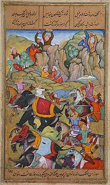
About 1526, the Punjab governor Dawlat Khan Lodī reached out to the Mughal Babur and invited him to attack Delhi Sultanate. Babur defeated and killed Ibrahim Lodi in the Battle of Panipat in 1526. The death of Ibrahim Lodi ended the Delhi Sultanate, and the Mughal Empire replaced it.[138]
_in_Mughal_Court%2C_1650.jpg)
The modern history period of South Asia, that is 16th-century onwards, witnessed the start of the Central Asian dynasty named the Mughals, with Turkish-Mongol roots and Sunni Islam theology. The first ruler was Babur, whose empire extended the northwest and Indo-Gangetic Plain regions of South Asia. The Deccan and northeastern region of South Asia was largely under Hindu kings such as those of Vijayanagara Empire and Ahom kingdom,[139] with some regions such as parts of modern Telangana and Andhra Pradesh under local Sultanates such as the Shia Islamic rulers of Golconda Sultanate.[140]
The Mughal Empire continued its wars of expansion after Babur's death. With the fall of the Rajput kingdoms and Vijayanagara, its boundaries encompassed almost the entirety of the Indian subcontinent.[141] The Mughal Empire was marked by a period of artistic exchanges and a Central Asian and South Asian architecture synthesis, with remarkable buildings such as the Taj Mahal.[142] At its height, the empire was the world's largest economy, worth almost 25% of global GDP, more than the entirety of Western Europe.[143][144]
However, this time also marked an extended period of religious persecution.[145] Two of the religious leaders of Sikhism, Guru Arjan and Guru Tegh Bahadur were arrested under orders of the Mughal emperors and were asked to convert to Islam, and were executed when they refused.[146][147][148] Religious taxes on non-Muslims called jizya were imposed. Buddhist, Hindu and Sikh temples were desecrated. However, not all Muslim rulers persecuted non-Muslims. Akbar, a Mughal ruler for example, sought religious tolerance and abolished jizya.[149][150][151][152]
In Aurangzeb's time, almost all of South Asia was claimed by the Mughal Empire. Under Aurangzeb's rule, South Asia reached its zenith, becoming the world's largest economy and biggest manufacturing power, estimated over 25% of world GDP, a value higher than China's and entire Western Europe's one.[143][144]
The economic developments on South Asia waved the period of proto-industrialization.[153]
After the death of Aurangzeb and the collapse of the Mughal Empire, which marks the beginning of modern India, in the early 18th century, it provided opportunities for the Marathas, Sikhs, Mysoreans and Nawabs of Bengal to exercise control over large regions of the Indian subcontinent.[154][155]
Modern era
Maritime trading between South Asia and European merchants began after the Portuguese explorer Vasco de Gama returned to Europe. British, French, Portuguese colonial interests struck treaties with these rulers and established their trading ports. In northwest South Asia, a large region was consolidated into the Sikh Empire by Ranjit Singh.[156][157] After the defeat of the Nawab of Bengal and Tipu Sultan and his French allies, the British Empire expanded their interests till the Hindu Kush region. In the east, the Bengal region was split into Muslim East Bengal and Hindu West Bengal, by the colonial British empire, in the early 1900s, a split that was reversed. However, after World War II, at the eve of India's independence, the region was split again into East Pakistan and West Bengal. East Pakistan became Bangladesh in 1971.[158][159]
Geography

According to Saul Cohen, early colonial era strategists treated South Asia with East Asia, but in reality, the South Asia region excluding Afghanistan is a distinct geopolitical region separated from other nearby geostrategic realms, one that is geographically diverse.[160] The region is home to a variety of geographical features, such as glaciers, rainforests, valleys, deserts, and grasslands that are typical of much larger continents. It is surrounded by three water bodies – the Bay of Bengal, the Indian Ocean and the Arabian Sea – and has acutely varied climate zones. The tip of the Indian Peninsula had the highest quality pearls.[161]
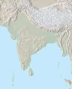
Indian plate
Most of this region is resting on the Indian Plate, the northerly portion of the Indo-Australian Plate, separated from the rest of the Eurasian Plate. The Indian Plate includes most of South Asia, forming a land mass which extends from the Himalayas into a portion of the basin under the Indian Ocean, including parts of South China and Eastern Indonesia, as well as Kunlun and Karakoram ranges,[162][163] and extending up to but not including Ladakh, Kohistan, the Hindu Kush range and Balochistan.[164][165][166] It may be noted that geophysically the Yarlung Tsangpo River in Tibet is situated at the outside of the border of the regional structure, while the Pamir Mountains in Tajikistan are situated inside that border.[167]
It was once a small continent before colliding with the Eurasian Plate about 50–55 million years ago and giving birth to the Himalayan range and the Tibetan plateau. It is the peninsular region south of the Himalayas and Kuen Lun mountain ranges and east of the Indus River and the Iranian Plateau, extending southward into the Indian Ocean between the Arabian Sea (to the southwest) and the Bay of Bengal (to the southeast).
Climate
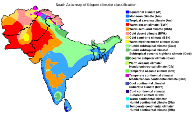
The climate of this vast region varies considerably from area to area from tropical monsoon in the south to temperate in the north. The variety is influenced by not only the altitude but also by factors such as proximity to the seacoast and the seasonal impact of the monsoons. Southern parts are mostly hot in summers and receive rain during monsoon periods. The northern belt of Indo-Gangetic plains also is hot in summer, but cooler in winter. The mountainous north is colder and receives snowfall at higher altitudes of Himalayan ranges.
As the Himalayas block the north-Asian bitter cold winds, the temperatures are considerably moderate in the plains down below. For the most part, the climate of the region is called the Monsoon climate, which keeps the region humid during summer and dry during winter, and favours the cultivation of jute, tea, rice, and various vegetables in this region.
South Asia is largely divided into four broad climate zones:[169]
- The northern Indian edge and northern Pakistani uplands have a dry subtropical continental climate
- The far south of India and southwest Sri Lanka have an equatorial climate
- Most of the peninsula has a tropical climate with variations:
- Hot subtropical climate in northwest India
- Cool winter hot tropical climate in Bangladesh
- Tropical semi-arid climate in the center
- The Himalayas and most of the Hindu Kush have an Alpine climate
Maximum relative humidity of over 80% has been recorded in Khasi and Jaintia Hills and Sri Lanka, while the area adjustment to Pakistan and western India records lower than 20%–30%.[169] Climate of South Asia is largely characterized by monsoons. South Asia depends critically on monsoon rainfall.[170] Two monsoon systems exist in the region:[171]
- The summer monsoon: Wind blows from the southwest to most parts of the region. It accounts for 70%–90% of the annual precipitation.
- The winter monsoon: Wind blows from the northeast. Dominant in Sri Lanka and Maldives.
The warmest period of the year precedes the monsoon season (March to mid June). In the summer the low pressures are centered over the Indus-Gangetic Plain and high wind from the Indian Ocean blows towards the center. The monsoons are the second coolest season of the year because of high humidity and cloud covering. But, at the beginning of June, the jetstreams vanish above the Tibetan Plateau, low pressure over the Indus Valley deepens and the Intertropical Convergence Zone (ITCZ) moves in. The change is violent. Moderately vigorous monsoon depressions form in the Bay of Bengal and make landfall from June to September.[169]
Land and water area
This list includes dependent territories within their sovereign states (including uninhabited territories), but does not include claims on Antarctica. EEZ+TIA is exclusive economic zone (EEZ) plus total internal area (TIA) which includes land and internal waters.
| Rank | Country | Area | EEZ | Shelf | EEZ+TIA |
|---|---|---|---|---|---|
| 1 | 3,287,263 | 2,305,143 | 402,996 | 5,592,406 | |
| 2 | 881,913 | 290,000 | 51,383 | 1,117,911 | |
| 3 | 652,864 | 0 | 0 | 652,864 | |
| 4 | 147,570 | 86,392 | 66,438 | 230,390 | |
| 5 | 147,181 | 0 | 0 | 147,181 | |
| 6 | 65,610 | 532,619 | 32,453 | 598,229 | |
| 7 | 38,394 | 0 | 0 | 38,394 | |
| 8 | 298 | 923,322 | 34,538 | 923,622 | |
| Total | 5,221,093 | 4,137,476 | 587,808 | 9,300,997 | |
Society
Languages
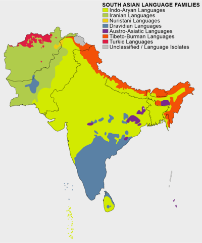
There are numerous languages in South Asia. The spoken languages of the region are largely based on geography and shared across religious boundaries, but the written script is sharply divided by religious boundaries. In particular, Muslims of South Asia such as in Afghanistan and Pakistan use the Arabic alphabet and Persian Nastaliq. Till 1952, Muslim-majority Bangladesh (then known as East Pakistan) also mandated only the Nastaliq script, but after that adopted regional scripts and particularly Bengali, after the Language Movement for the adoption of Bengali as the official language of the then East Pakistan. Non-Muslims of South Asia, and some Muslims in India, on the other hand, use their traditional ancient heritage scripts such as those derived from Brahmi script for Indo-European languages and non-Brahmi scripts for Dravidian languages and others.[172]
The Nagari script has been the primus inter pares of the traditional South Asian scripts.[173] The Devanagari script is used for over 120 South Asian languages,[174] including Hindi,[175] Marathi, Nepali, Pali, Konkani, Bodo, Sindhi and Maithili among other languages and dialects, making it one of the most used and adopted writing systems in the world.[176] The Devanagari script is also used for classical Sanskrit texts.[174]
The largest spoken language in this region is Hindi, followed by Bengali, Tamil, Telugu, Marathi, Gujarati and Punjabi.[172] In the modern era, new syncretic languages developed in the region such as Urdu that is used by the Muslim community of northern South Asia (particularly Pakistan and northern states of India).[177] The Punjabi language spans three religions: Islam, Hinduism, and Sikhism. The spoken language is similar, but it is written in three scripts. The Sikh use Gurmukhi alphabet, Muslim Punjabis in Pakistan use the Nastaliq script, while Hindu Punjabis in India use the Gurmukhi or Nāgarī script. The Gurmukhi and Nagari scripts are distinct but close in their structure, but the Persian Nastaliq script is very different.[178]
English, with British spelling, is commonly used in urban areas and is a major economic lingua franca of South Asia.[179]
Religions
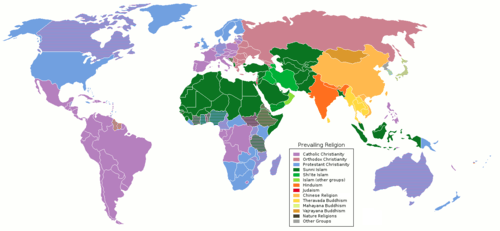
In 2010, South Asia had the world's largest population of Hindus, Jains and Sikhs,[15] about 510 million Muslims,[15] as well as over 25 million Buddhists and 35 million Christians.[13] Hindus make up about 68 percent or about 900 million and Muslims at 31 percent or 510 million of the overall South Asia population,[180] while Buddhists, Jains, Christians and Sikhs constitute most of the rest. The Hindus, Buddhists, Jains, Sikhs and Christians are concentrated in India, Nepal, Sri Lanka and Bhutan, while the Muslims are concentrated in Afghanistan (99%), Bangladesh (90%), Pakistan (96%) and Maldives (100%).[15]
Indian religions are the religions that originated in the India; namely Hinduism, Jainism, Buddhism and Sikhism.[181] The Indian religions are distinct yet share terminology, concepts, goals and ideas, and from South Asia spread into East Asia and southeast Asia.[181] Early Christianity and Islam were introduced into coastal regions of South Asia by merchants who settled among the local populations. Later Sindh, Balochistan, and parts of the Punjab region saw conquest by the Arab caliphates along with an influx of Muslims from Persia and Central Asia, which resulted in spread of both Shia and Sunni Islam in parts of northwestern region of South Asia. Subsequently, under the influence of Muslim rulers of the Islamic sultanates and the Mughal Empire, Islam spread in South Asia.[182][183] About one-third of the Muslims are from South Asia.[184][185][186]
| Country | State religion | Religious population as a percentage of total population | ||||||||
|---|---|---|---|---|---|---|---|---|---|---|
| Ahmadiyya | Buddhism | Christianity | Hinduism | Islam | Kiratism | Sikhism | Others | Year reported | ||
| Islam | - | - | - | - | 99.7% | - | - | 0.3% | 2019[187] | |
| Islam | 0.06% | 0.6% | 0.4% | 9.5% | 89.5% | - | ~0.0% | - | 2011[188] | |
| Budhhism | - | 74.8% | 0.5% | 22.6% | 0.1% | - | - | 2% | 2010[189][190] | |
| None | - | 0.7% | 2.3% | 79.8% | 14.2% | - | 1.7% | 1.3% | 2011[191][192] | |
| Sunni Islam | - | - | - | - | 100% | - | - | - | [193][194][195] | |
| None | - | 9% | 1.3% | 81.3% | 4.4% | 3% | - | 0.8% | 2013[196] | |
| Islam | 0.22% | - | 1.59% | 1.85% | 96.28% | - | - | 0.07% | 2010[197] | |
| Theravada Buddhism | - | 70.2% | 6.2% | 12.6% | 9.7% | - | - | 1.4% | 2011[198] | |
Demographics
The population of South Asia is about 1.749 billion which makes it the most populated region in the world.[199] It is socially very mixed, consisting of many language groups and religions, and social practices in one region that are vastly different from those in another.[200]
Largest urban areas
South Asia is home to some of the most populated cities in the world. Dhaka, Delhi, Mumbai and Karachi are four of the world's largest megacities.
| Rank | City | State/Province | Country | Population[201] | Area (km2)[201] | Density (/km2)[201] | Classification |
|---|---|---|---|---|---|---|---|
| 1 | Delhi | National Capital Region | 25,399,141 | 2,072 | 12,100 | Capital region | |
| 2 | Karachi | Sindh | 20,431,848 | 3780[202] | 5500 | Metropolis | |
| 3 | Dhaka | Dhaka Division | 20,283,552 | 360 | 43,500 | Capital city | |
| 4 | Mumbai | Maharashtra | 20,185,064 | 546 | 32,400 | Megacity | |
| 5 | Kolkata | West Bengal | 14,667,000 | 1,204 | 12,200 | Megacity | |
| 6 | Lahore | Punjab | 12,414,000 | 1772[203] | 12,700 | Megacity | |
| 7 | Bengaluru | Karnataka | 10,248,000 | 1,116 | 8,400 | Megacity | |
| 8 | Chennai | Tamil Nadu | 9,714,000 | 375 | 25,900 | Metropolis | |
| 9 | Hyderabad | Telangana | 8,754,000 | 971 | 10,000 | Metropolis | |
| 10 | Faisalabad | Punjab | 7,873,910[204] | 5856 | 1340 | City District |
Population projections
Population of South Asian countries in 1950, 1975, 2000, 2025, 2050, 2075 and 2100 projection from the United Nations has been displayed in table. The given population projections are based on medium fertility index. With India and Bangladesh approaching replacement rates fast, population growth in South Asia is facing steep decline and may turn negative in mid 21st century.[1][2]
| Rank | Country | Population (in thousands) | ||||||
|---|---|---|---|---|---|---|---|---|
| 1950 | 1975 | 2000 | 2025 | 2050 | 2075 | 2100 | ||
| 1 | 376,325 | 623,103 | 1,056,576 | 1,445,012 | 1,639,176 | 1,609,041 | 1,450,421 | |
| 2 | 37,542 | 66,817 | 142,344 | 242,234 | 338,013 | 394,265 | 403,103 | |
| 3 | 37,895 | 70,066 | 127,658 | 170,937 | 192,568 | 181,282 | 151,393 | |
| 4 | 7,752 | 12,689 | 20,779 | 43,531 | 64,682 | 76,199 | 75,974 | |
| 5 | 8,483 | 13,420 | 23,941 | 31,757 | 35,324 | 31,818 | 23,708 | |
| 6 | 7,971 | 13,755 | 18,778 | 21,780 | 21,814 | 19,194 | 15,275 | |
| 7 | 177 | 348 | 591 | 811 | 905 | 845 | 686 | |
| 8 | 74 | 136 | 279 | 522 | 586 | 564 | 490 | |
| Total | 476,220 | 800,335 | 1,390,946 | 1,958,046 | 2,293,069 | 2,313,208 | 2,120,014 | |
Economy
India is the largest and fastest-growing economy in the region (US$2.957 trillion) and makes up almost 80% of the South Asian economy; it is the world's 5th largest in nominal terms and 3rd largest by purchasing power adjusted exchange rates (US$10.385 trillion).[3] India is the only member of powerful G-20 major economies and BRICS from the region. It is the fastest-growing major economy in the world and one of the world's fastest registering a growth of 7.3% in FY 2014–15.
India is followed by Bangladesh, which has a GDP of ($314.656 billion) and a GDP per capita of $1888, which is 4th in the region. It has the fastest GDP growth rate in Asia. It is one of the emerging and growth-leading economies of the world, and It is also listed among the Next Eleven countries. It is also one of the fastest-growing middle-income countries. It has the world's 39th largest GDP in nominal terms and is the 29th largest by purchasing power adjusted exchange rates ($829.272 billion). Bangladesh's economic growth crossed 7% in fiscal 2015–2016 after almost a decade in the region of 6%, It's expected to grow by 8.13% in 2019–2020.
Pakistan has an economy of ($314 billion) and ranks 5th in GDP per capita in the region.[205]
Next is Sri Lanka, which has the 2nd highest GDP per capita and the 4th largest economy in the region. According to a World Bank report in 2015, driven by a strong expansion in India, coupled with favorable oil prices, from the last quarter of 2014 South Asia became the fastest-growing region in the world[206]
The major stock exchanges in the region are Bombay Stock Exchange (BSE) with market Capitalization of $2.298 trillion (11th largest in the world), National Stock Exchange of India (NSE) with market capitalization of $2.273 trillion (12th largest in the world), Dhaka Stock Exchange (DSE) and Pakistan Stock Exchange (PSX) with market capitalization of $72 billion.[207] Economic data is sourced from the International Monetary Fund, current as of April 2017, and is given in US dollars.[208]
| Country [209][209][210][211] |
Currency | Population (2016)[212] |
Nominal GDP (2017)[213] |
GDP per capita
(2017)[214] |
GDP growth
(2017)[215] |
Inflation
(2017)[216] |
|---|---|---|---|---|---|---|
| ؋ Afghani | 37,171,921 | $21.657 billion | $601 | 3% | 6% | |
| ৳ Bangladeshi Taka | 161,376,708 | $314.656 billion | $2,067 | 8.2% | 5.44% | |
| Nu. Ngultrum | 754,388 | $2.31 billion | $3,215 | 5.9% | 4.1% | |
| ₹ Indian Rupee | 1,352,642,280 | $2.971 trillion | $2,198 | 7.0% | 4.8% | |
| ރ Rufiyaa | 515,696 | $4.825 billion | $14,501 | 4.1% | 2.5% | |
| रु Rupee | 28,095,714 | $27 billion | $919 | 7.7% | 6.2% | |
| ₨ Pakistani Rupee | 212,228,286 | $278.019 billion | $1,357 | 5.2% | 4.3% | |
| රු/ரூ Rupee | 21,228,763 | $92.504 billion | $4,265 | 3.0% | 5.8% |
Health and nutrition
| Afghanistan | Bangladesh | Bhutan | India | Maldives | Nepal | Pakistan | Sri Lanka | ||
|---|---|---|---|---|---|---|---|---|---|
| Population undernourished (2015)[217] | 26.8% | 16.4% | N/A | 15.2% | 5.2% | 7.8% | 22% | 22% | |
| Population below poverty line (CIA Factbook)[218] | 35.8% | 7.5% | 12% | 21.2% | 16% | 25.2% | 24.3% | 8.9% | |
According to WHO, South Asia is home to two out of the three countries in the world still affected by polio, Pakistan and Afghanistan, with 306 & 28 polio cases registered in 2014 respectively.[219] Attempts to eradicate polio have been badly hit by opposition from militants in both countries, who say the program is cover to spy on their operations. Their attacks on immunization teams have claimed 78 lives since December 2012.[220]
According to the World Bank's 2011 report, based on 2005 ICP PPP, about 24.6% of the South Asian population falls below the international poverty line of $1.25/day.[221] Afghanistan and Bangladesh rank the highest, with 30.6% and 43.3% of their respective populations below the poverty line. Bhutan, Maldives and Sri Lanka have the lowest number of people below the poverty line, with 2.4%, 1.5% and 4.1% respectively. India has lifted the most people in the region above the poverty line between 2008 and 2011, around 140 million. As of 2011, 21.9% of India's population lives below the poverty line, compared to 41.6% in 2005.[222][223]
The World Bank estimates that India is one of the highest ranking countries in the world for the number of children suffering from malnutrition. The prevalence of underweight children in India is among the highest in the world and is nearly double that of Sub Saharan Africa with dire consequences for mobility, mortality, productivity, and economic growth.[224]
According to the World Bank, 70% of the South Asian population and about 75% of South Asia's poor live in rural areas and most rely on agriculture for their livelihood[225] according to the UN's Food and Agricultural Organisation. In 2015, approximately 281 million people in the region were malnourished. The report says that Nepal reached both the WFS target as well as MDG and is moving towards bringing down the number of undernourished people to less than 5% of the population.[217] Bangladesh reached the MDG target with the National Food Policy framework – with only 16.5% of the population undernourished. In India, the malnourished comprise just over 15 percent of the population. While the number of malnourished people in the neighborhood has shown a decline over the last 25 years, the number of under-nourished in Pakistan displays an upward trend. There were 28.7 million hungry in Pakistan in the 1990s – a number that has steadily increased to 41.3 million in 2015 with 22% of the population malnourished. Approximately 194.6 million people are undernourished in India, which accounts for the highest number of people suffering from hunger in any single country.[217][226]
The 2006 report stated, "the low status of women in South Asian countries and their lack of nutritional knowledge are important determinants of high prevalence of underweight children in the region". Corruption and the lack of initiative on the part of the government has been one of the major problems associated with nutrition in India. Illiteracy in villages has been found to be one of the major issues that need more government attention. The report mentioned that although there has been a reduction in malnutrition due to the Green Revolution in South Asia, there is concern that South Asia has "inadequate feeding and caring practices for young children".[227]
General statistical data
Below is the latest general statistical data for South Asian nations. Their total population, area and GDPs have been cited along with their shares of percentage of this attribute of total South Asia in bracket. Republic of India accounts for most of landmass, population and GDP and hence, heavily influences average of South Asian development attributes. Sri Lanka and Maldives are leaders in the region in terms of Human Development Index and GDP per capita while Afghanistan scores lowest in terms of both the attributes in the region.
| Country [209][209][210][211] |
Capital [211][228][229] |
Area (km2) (%Share) [230] |
Population in thousands (2019) (%Share)[1][2] |
Density (per km2) |
Nominal GDP (in millions) (2019) (%Share)[231] |
GDP per capita
(2019)[232] |
GDP (PPP) (in millions) (2019) (%Share) |
GDP (PPP) per capita (2019) | HDI
(2018)[4] |
|---|---|---|---|---|---|---|---|---|---|
| Kabul | 652,230 (12.7%) | 38,042 (2.07%) | 58.3 | $18,734 (0.51%) | $513 | $76,714 (0.55%) | $2,101 | ||
| Dhaka | 147,570 (2.87%) | 163,046 (8.88%) | 1,104.9 | $317,465 (8.67%) | $1,906 | $829,270 (5.92%) | $4,992 | ||
| Thimphu | 38,394 (0.75%) | 763 (0.04%) | 19.8 | $2,842 (0.08%) | $3,423 | $9,310 (0.066%) | $10,193 | ||
| New Delhi | 3,287,263 (64.02%) | 1,366,418 (74.45%) | 415.6 | $2,935,570 (80.16%) | $2,172 | $11436,697 (81.68%) | $8,484 | ||
| Malé | 298 (0.006%) | 531 (0.03%) | 1,781.8 | $5,786 (0.16%) | $15,563 | $6,708 (0.048%) | $21,320 | ||
| Kathmandu | 147,181 (2.87%) | 28,609 (1.56%) | 194.3 | $29,813 (0.81%) | $1,048 | $87,472 (0.62%) | $2,984 | ||
| Islamabad | 796,095 (15.5%) | 216,565 (11.8%) | 245.8 | $284,214 (7.76%) | $1,388 | $1,235,663 (8.82%) | $5,839 | ||
| Colombo | 65,610 (1.28%) | 21,324 (1.62%) | 325 | $86,566 (2.36%) | $3,947 | $319,791 (2.28%) | $14,680 | ||
| South Asia | 5,134,641 (100%) | 1,835,297 (100%) | 357.4 | $3,662,255 (100%) | $2,064 | $14,001, 625 (100%) | $7,629 | ||
Governance and politics
Systems of government


Countries and territories from extended definitions
| Country or region | Capital | Administrative division type | Head of government | Area (km2) | Population | Official language | Coat of arms |
|---|---|---|---|---|---|---|---|
| Diego Garcia | British Overseas Territory | Commissioner | 54,400 | 2,500 | English | .svg.png) | |
| Tehran | Islamic republic | Supreme Leader | 1,648,195 | 83,183,741 | Persian | ||
| Naypyidaw | Unitary parliamentary constitutional republic | State Counsellor | 676,578 | 51,486,253 | Burmese | ||
| Lhasa | Autonomous Region of China | Chairman | 1,228,400 | 3,180,000 | Tibetan, Mandarin |  |
India is a secular federative parliamentary republic with premier as head of government. With most populous functional democracy in world[233] and world's longest written constitution,[234][235][236] India has been stably sustaining the political system it adopted in 1950 with no regime change except that by a democratic election. India's sustained democratic freedoms are unique among the world's newer establishments. Since the formation of its republic abolishing British law, it has remained a democracy with civil liberties, an active Supreme Court, and a largely independent press.[237] India leads region in democracy index. It has a multi-party system in its internal regional politics[238] whereas alternative transfer of powers to alliances of Indian left-wing and right-wing political parties in national government provide it with characteristics of a two-party state.[239] India has been facing notable internal religious conflicts and separatism however consistently becoming more and more stable with time.
Foundation of Pakistan lies in Pakistan movement started in colonial India based on Islamic nationalism. Pakistan is a federal parliamentary Islamic republic and was the world's first country to adopt Islamic republic system to modify its republican status under its otherwise secular constitution in 1956. Pakistan's governance is one of the most conflicted in the world. The military rule and the unstable government in Pakistan has become a concern for the South Asian region. Out of 22 appointed Pakistani Prime ministers, none has been able to complete a full term in office.[240] The nature of Pakistani politics can be characterized as a multi-party system. Pakistan's governance is one of the most conflicted in the region. The military rule and the unstable government in Pakistan have become a concern for the South Asian region. In Nepal, the government has struggled to come in the side of democracy, and it only showed signs in the recent past, basically in the 21st century, to support the democratic system.
Bangladesh is a unitary parliamentary republic. Law of Bangladesh defines it as both Islamic[241] as well as secular.[242] The nature of Bangladeshi politics can be characterized as a multi-party system. Bangladesh is a unitary state and parliamentary democracy.[243] Bangladesh also stands out as one of the few Muslim-majority democracies. "It is a moderate and generally secular and tolerant — though sometimes this is getting stretched at the moment — alternative to violent extremism in a very troubled part of the world", said Dan Mozena, the U.S. ambassador to Bangladesh. Although Bangladesh's legal code is secular, more citizens are embracing a conservative version of Islam, with some pushing for sharia law, analysts say. Experts say that the rise in conservatism reflects the influence of foreign-financed Islamic charities and the more austere version of Islam brought home by migrant workers in Persian Gulf countries.[244]
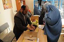
Afghanistan has been a unitary presidential Islamic republic since 2004. Afghanistan has been suffering from one of the most unstable regimes on earth as a result of multiple foreign invasions, civil wars, revolutions and terrorist groups. Persisting instability for decades have left country's economy stagnated and torn and Afghanistan remains one of most poor and least developed countries on the planet, leading to the influx of Afghan refugees to neighboring countries like Iran.[187]
The unitary semi-presidential constitutional republic of Sri Lanka is oldest sustained democracy in Asia. Tensions between Sinhalese and Tamils led to Sri Lankan civil war that undermined the country's stability for more than two and a half decades.[245] Sri Lanka however, has been leading region in HDI with per capita GDP well ahead of India and Bangladesh. The political situation in Sri Lanka has been dominated by an increasingly assertive Sinhalese nationalism, and the emergence of a Tamil separatist movement under LTTE, which was suppressed in May 2009.
Nepal was the last Hindu state in world before becoming a secular democratic republic in 2008. The country has been ranked among world's poorest in terms of GDP per capita but has made considerable progress in development indicators outpacing many other South Asian states.
Bhutan is a Buddhist state with a constitutional monarchy. The country has been ranked as the least corrupt and peaceful with most economic freedom in the region in 2016. Myanmar's politics is dominated by a military Junta, which has sidelined the democratic forces led by Aung San Suu Kyi. Maldives is a unitary presidential republic with Sunni Islam strictly as the state religion.
Myanmar's politics is dominated by a military Junta, which has sidelined the democratic forces led by Aung San Suu Kyi.
| Afghanistan | Bangladesh | Bhutan | India | Maldives | Nepal | Pakistan | Sri Lanka | ||
|---|---|---|---|---|---|---|---|---|---|
| Inequality-adjusted HDI (2018)[4] (global ranking of 150) | No data | 101 | 107 | 99 | 87 | 112 | 120 | 54 | |
| Corruption Perception Index (2019)[246] (global ranking of 168) | 173 | 146 | 25 | 80 | 130 | 113 | 120 | 93 | |
| The Worldwide Governance Indicators (2015)[247] |
Government Effectiveness | 8% | 24% | 68% | 56% | 41% | 13% | 27% | 53% |
| Political stability and absence of violence/terrorism |
1% | 11% | 89% | 17% | 61% | 16% | 1% | 47% | |
| Rule of law | 2% | 27% | 70% | 56% | 35% | 27% | 24% | 60% | |
| Voice and accountability | 16% | 31% | 46% | 61% | 30% | 33% | 27% | 36% | |
| Population below poverty line (2011)[248] | 35.8% | 31.5% | 23.7% | 21.9% | 16% | 25.2% | 21.4% | 8.9% | |
| Primary School Enrollment[249] | 29% | 90% | 85% | 92% | 94% | 96% | 73% | 98% | |
| Secondary School Enrollment[250] | 49% | 54% | 78% | 68% | N/A | 72% | 38% | 96% | |
Regional politics
The dominant political powers in the region are India,[251][252][253] Pakistan,[254][255] and Bangladesh. India is by far the largest country in the area covering around three-fourths the land area of the South Asian region. India has the largest population of around three times the combined population of the 6 other countries in the region.[256] India is also the world's largest democracy. India's defense budget is $66.5 billion which exceeds to the whole Pakistan's Federal budget of $42 billion for 2018-19 greatly.[257]
South Asian Association for Regional Cooperation or SAARC has been the primary regional supranational body comprising all current South Asian nations. The idea of cooperation among South Asian countries was first discussed in New Delhi in April 1947.[258] In 1970s, South Asian countries agreed upon forming a trade bloc within the region. Soviet invasion of Afghanistan in 1979 accelerated efforts to form a union to restrengthen deteriorating regional security.[259] After agreements, the union was finally established in Dhaka in December 1985.[260] However, deterioration of India-Pakistan ties have led India to emphasize more on sub-regional groups SASEC and BBIN. Due to 2016 Uri terror attack on Indian security forces, India, Afghanistan, Bangladesh, Bhutan, Sri Lanka and Maldives pulled out of 19th summit of SAARC that was supposed to be held in Pakistan which led to its ultimate cancellation.[261][262] South Asia continues to remain least integrated region in the world. Meanwhile, in East Asia, regional trade accounts for 50% of total trade, it accounts for only a little more than 5% in South Asia.[263]
Populism is a general characteristic of internal politics of South Asian nations.[264] Diplomacy among the countries of South Asia has been mainly driven by populist politics, with the centre-stage taken by India-Pakistan conflict ever since their independence in 1947, and then the creation of Bangladesh under tense circumstances in 1971. During the height of Cold war, the elite political leaders of Pakistan aligned with the US, while India played crucial role informing the Non-Aligned Movement and while maintaining goodwill relations with the USSR.
Regional groups of countries
| Name of country/region, with flag | Area (km2) |
Population | Population density (per km2) |
Capital or Secretariat | Currency | Countries included | Official languages | Coat of Arms |
|---|---|---|---|---|---|---|---|---|
| Core Definition (above) of South Asia | 5,220,460 | 1,726,907,000 | 330.79 | N/A | N/A | Afghanistan, Bangladesh, Bhutan, India, Maldives, Nepal, Pakistan, Sri Lanka | N/A | N/A |
| UNSD of South Asia | 6,778,083 | 1,702,000,000 | 270.77 | N/A | N/A | Afghanistan, Bangladesh, Bhutan, India, Iran, Maldives, Nepal, Pakistan, Sri Lanka | N/A | N/A |
| SAARC | 4,637,469 | 1,626,000,000 | 350.6 | Kathmandu | N/A | Afghanistan, Bangladesh, Bhutan, India, Maldives, Nepal, Pakistan, Sri Lanka | English | N/A |
| BBIN | 3,499,559 | 1,465,236,000 | 418.69 | N/A | N/A | Bangladesh, Bhutan, India, Nepal | N/A | N/A |
| SASEC | 3,565,467 | 1,485,909,931 | 416.75 | N/A | N/A | Bangladesh, Bhutan, India, Nepal, Sri Lanka, Maldives | N/A | N/A |
See also
Notes
- Among the top 100 urban areas of the world by population.
- Afghanistan is considered to be part of Central Asia. It regards itself as a link between Central Asia and South Asia.[6]
- According to the UN cartographic section website disclaimers, "DESIGNATIONS USED: The depiction and use of boundaries, geographic names and related data shown on maps and included in lists, tables, documents, and databases on this web site are not warranted to be error free nor do they necessarily imply official endorsement or acceptance by the United Nations."[48]
- Doniger 2010, p. 66: "Much of what we now call Hinduism may have had roots in cultures that thrived in South Asia long before the creation of textual evidence that we can decipher with any confidence. Remarkable cave paintings have been preserved from Mesolithic sites dating from c. 30,000 BCE in Bhimbetka, near present-day Bhopal, in the Vindhya Mountains in the province of Madhya Pradesh."
- Jones & Ryan 2006, p. xvii: "Some practices of Hinduism must have originated in Neolithic times (c. 4000 BCE). The worship of certain plants and animals as sacred, for instance, could very likely have very great antiquity. The worship of goddesses, too, a part of Hinduism today, maybe a feature that originated in the Neolithic."
- Michaels: "They called themselves arya ("Aryans," literally "the hospitable," from the Vedic arya, "homey, the hospitable") but even in the Rgveda, arya denotes a cultural and linguistic boundary and not only a racial one."[91]
References
Citations
- "World Population prospects – Population division". United Nations. Archived from the original on 5 February 2019. Retrieved 16 July 2019.
- "Overall total population" (xlsx). United Nations. Retrieved 16 July 2019.
- "Report for Selected Countries and Subjects". imf.org. IMF. Outlook Database, October 2018
- "Human Development Report 2019 – "Human Development Indices and Indicators"" (PDF). HDRO (Human Development Report Office) United Nations Development Programme. pp. 22–25. Retrieved 10 December 2019.
- "Afghanistan". Regional and Country Profiles South Asia. Institute of Development Studies. Archived from the original on 20 May 2017. Retrieved 28 February 2019.;
"Composition of macro geographical (continental) regions, geographical sub-regions, and selected economic and other groupings: Southern Asia". United Nations Statistics Division. Archived from the original on 17 April 2010. Retrieved 31 January 2016.;
Arnall, A (24 September 2010). "Adaptive Social Protection: Mapping the Evidence and Policy Context in the Agriculture Sector in South Asia". Institute of Development Studies (345). Archived from the original on 15 June 2016. Retrieved 31 January 2016.;
"The World Bank". Archived from the original on 10 November 2015. Retrieved 5 November 2015.;
"Institute of Development Studies: Afghanistan". Archived from the original on 1 June 2017. Retrieved 28 February 2019.;
"Harvard South Asia Institute: "Afghanistan"". Archived from the original on 17 November 2015. Retrieved 5 November 2015.;
"Afghanistan". BBC News. 31 January 2018. Archived from the original on 29 July 2018. Retrieved 21 July 2018.;
"The Brookings Institution". 30 November 2001. Archived from the original on 5 September 2015. Retrieved 5 November 2015.;
"South Asia". The World Factbook. Central Intelligence Agency. Archived from the original on 2 April 2015. Retrieved 4 March 2015. - Saez 2012, p. 35.
- SAARC Summit. "SAARC". SAARC Summit. Archived from the original on 16 December 2013. Retrieved 17 December 2013.
- "South Asia Regional Overview". South Asian Regional Development Gateway. Archived from the original on 21 November 2008.
- Desai, Praful B. 2002. Cancer control efforts in the Indian subcontinent. Japanese Journal of Clinical Oncology. 32 (Supplement 1): S13-S16. "The Indian subcontinent in South Asia occupies 2.4% of the world landmass and is home to 16.5% of the world population...."
- "Asia" > Overview Archived 1 May 2011 at the Wayback Machine. Encyclopædia Britannica. Encyclopædia Britannica Online, 2009: "The Indian subcontinent is home to a vast diversity of peoples, most of whom speak languages from the Indo-Aryan subgroup of the Indo-European family."
- "Indian Subcontinent Archived 21 January 2012 at the Wayback Machine". Encyclopedia of Modern Asia. Macmillan Reference USA (Gale Group), 2006: "The area is divided between five major nation-states, Bangladesh, India, Nepal, Pakistan, and Sri Lanka, and includes as well the two small nations of Bhutan and the Maldives Republic... The total area can be estimated at 4.4 million square kilometres or exactly 10 percent of the land surface of Asia... In 2000, the total population was about 22 percent of the world's population and 34 percent of the population of Asia."
- Diplomat, Akhilesh Pillalamarri, The. "How South Asia Will Save Global Islam". The Diplomat. Retrieved 7 February 2017.
- "Religion population totals in 2010 by Country". Pew Research Center. 2012. Archived from the original on 9 December 2016.
- Pechilis, Karen; Raj, Selva J. (2013). South Asian Religions: Tradition and Today. Routledge. p. 193. ISBN 9780415448512.
- "Region: Asia-Pacific". Pew Research Center. 27 January 2011. Archived from the original on 10 October 2017. Retrieved 13 March 2016.
- "10 Countries With the Largest Muslim Populations, 2010 and 2050". Pew Research Center's Religion & Public Life Project. 2 April 2015. Archived from the original on 4 May 2017. Retrieved 7 February 2017.
- "Standard Country or Area Codes for Statistical Use". Millenniumindicators.un.org. Archived from the original on 11 July 2017. Retrieved 25 August 2012. Quote: "The assignment of countries or areas to specific groupings is for statistical convenience and does not imply any assumption regarding political or other affiliation of countries or territories by the United Nations."
- "The World Bank". Archived from the original on 10 November 2015. Retrieved 5 November 2015.
- "Institute of Development Studies: Afghanistan". Archived from the original on 1 June 2017. Retrieved 28 February 2019.
- "Harvard South Asia Institute: "Afghanistan"". Archived from the original on 17 November 2015. Retrieved 5 November 2015.
- "Afghanistan Country Profile". BBC News. Archived from the original on 29 July 2018. Retrieved 21 July 2018.
- "The Brookings Institution". 30 November 2001. Archived from the original on 5 September 2015. Retrieved 5 November 2015.
- "CIA "The World Factbook"". Archived from the original on 2 April 2015. Retrieved 4 March 2015.
- Ghosh, Partha Sarathy (1989). Cooperation and Conflict in South Asia. Technical Publications. pp. 4–5. ISBN 978-81-85054-68-1. Archived from the original on 16 May 2016. Retrieved 12 August 2015.
- Jona Razzaque (2004). Public Interest Environmental Litigation in India, Pakistan, and Bangladesh. Kluwer Law International. pp. 3 with footnotes 1 and 2. ISBN 978-90-411-2214-8. Archived from the original on 7 October 2017. Retrieved 11 December 2016.
- Keith Robbins (2012). Transforming the World: Global Political History since World War II. Palgrave Macmillan. p. 386. ISBN 978-1-137-29656-6., Quote: "Some thought that Afghanistan was part of the Middle East and not South Asian at all".
- Phillip Margulies (2008). Nuclear Nonproliferation. Infobase Publishing. p. 63. ISBN 978-1-4381-0902-2., Quote: "Afghanistan, which lies to the northwest, is not technically a part of South Asia but is an important neighbor with close links and historical ties to Pakistan."
- Baten, Jörg (2016). A History of the Global Economy. From 1500 to the Present. Cambridge University Press. p. 287. ISBN 978-1-107-50718-0.
- Sushil Mittal and Gene Thursby, Religions of South Asia: An Introduction, page 3, Routledge, 2006, ISBN 9781134593224
- United Nations, Yearbook of the United Nations, pages 297, Office of Public Information, 1947, United Nations
- Dale Hoiberg and Indu Ramchandani, Students' Britannica India (vol. 1), page 45, Popular Prakashan, 2000, ISBN 978-0-85229-760-5
- Bertram Hughes Farmer, An Introduction to South Asia, pages 1, Routledge, 1993, ISBN 0-415-05695-0
- Michael Mann (2014). South Asia's Modern History: Thematic Perspectives. Taylor & Francis. pp. 13–15. ISBN 978-1-317-62445-5.
- Ewan W. Anderson; Liam D. Anderson (2013). An Atlas of Middle Eastern Affairs. Routledge. p. 5. ISBN 978-1-136-64862-5., Quote: "To the east, Iran, as a Gulf state, offers a generally accepted limit to the Middle East. However, Afghanistan, also a Muslim state, is then left in isolation. It is not accepted as a part of Central Asia and it is clearly not part of the Indian subcontinent".
- Dallen J. Timothy and Gyan P. Nyaupane, Cultural Heritage and Tourism in the Developing World: A Regional Perspective, page 127, Routledge, 2009, ISBN 9781134002283
- Navnita Chadha Behera, International Relations in South Asia: Search for an Alternative Paradigm, page 129, SAGE Publications India, 2008, ISBN 9788178298702
- Saul Bernard Cohen (2008). Geopolitics: The Geography of International Relations (2 ed.). Rowman & Littlefield Publishers. p. 329. ISBN 9780742581548.
- McLeod, John (2002). The History of India. Greenwood Publishing Group. p. 1. ISBN 978-0-313-31459-9. Archived from the original on 17 May 2016. Retrieved 19 July 2015.
- Arthur Berriedale Keith, A Constitutional History of India: 1600–1935, pages 440–444, Methuen & Co, 1936
- N.D. Arora, Political Science for Civil Services Main Examination, page 42:1, Tata McGraw-Hill Education, 2010, 9780070090941
- Stephen Adolphe Wurm, Peter Mühlhäusler & Darrell T. Tryon, Atlas of languages of intercultural communication in the Pacific, Asia, and the Americas, pages 787, International Council for Philosophy and Humanistic Studies, Published by Walter de Gruyter, 1996, ISBN 3-11-013417-9
- "Indian subcontinent" > Geology and Geography Archived 20 February 2012 at the Wayback Machine.
- Haggett, Peter (2001). Encyclopedia of World Geography (Vol. 1). Marshall Cavendish. p. 2710. ISBN 978-0-7614-7289-6.
- Territories (British Indian Ocean Territory), Jane's Information Group
- Encyclopædia Britannica: A New Survey of Universal Knowledge (volume 4), pages 177, Encyclopædia Britannica Inc., 1947
- Ian Copland, The Princes of pre-India in the Endgame of the British Empire: 1917–1947, pages 263, Cambridge University Press, 2002, ISBN 0-521-89436-0
- Ben Cahoon. "Pakistan Princely States". Worldstatesmen.org. Archived from the original on 27 September 2007. Retrieved 23 August 2010.
- United Nations Cartographic Centre Archived 30 June 2017 at the Wayback Machine Retrieved 18 June 2015
- Sarkar, Sudeshna (16 May 2007). "SAARC: Afghanistan comes in from the cold". Current Affairs – Security Watch. Swiss Federal Institute of Technology, Zürich. Archived from the original on 14 June 2011. Retrieved 6 April 2011.
- "South Asian Organisation for Regional Cooperation (official website)". SAARC Secretariat, Kathmandu, Nepal. Archived from the original on 16 December 2013. Retrieved 6 April 2011.
- Chatterjee Aneek, International Relations Today: Concepts and Applications, page 166, Pearson Education India, ISBN 9788131733752
- "SAARC Membership: India blocks China's entry for the time being". The Economic Times. 2 December 2014. Archived from the original on 18 December 2018. Retrieved 17 March 2015.
- Global Summitry Project, SAARC
- South Asia: Data, Projects and Research Archived 16 July 2012 at Archive.today, The World Bank
- "SAFTA Protocol". Archived from the original on 15 March 2015. Retrieved 20 March 2015.
- "South Asia". Unicef.org. Archived from the original on 20 December 2016. Retrieved 16 December 2016.
- "UNICEF ROSA". Unicef.org. Archived from the original on 20 December 2016. Retrieved 16 December 2016.
- Mapping and Analysis of Agricultural Trade Liberalization in South Asia Archived 19 March 2009 at the Wayback Machine, Trade and Investment Division (TID), United Nations Economic and Social Commission for Asia and the Pacific
- Asia-Pacific POPIN Consultative Workshop Report Archived 25 October 2012 at the Wayback Machine, Asia-Pacific POPIN Bulletin, Vol. 7, No. 2 (1995), pages 7–11
- Geographical region and composition Archived 13 July 2011 at the Wayback Machine, Composition of macro geographical (continental) regions, geographical sub-regions, and selected economic and other groupings, United Nations
- "Asia" > Geology and Geography Archived 23 February 2012 at the Wayback Machine. The Columbia Electronic Encyclopedia, 6th ed. Columbia University Press, 2003: "Asia can be divided into six regions, each possessing distinctive physical, cultural, economic, and political characteristics... South Asia (Afghanistan and the nations of the Indian Peninsula) is isolated from the rest of Asia by great mountain barriers."
- "Asia" > Geologic history – Tectonic framework Archived 1 May 2011 at the Wayback Machine. Encyclopædia Britannica. Encyclopædia Britannica Online, 2009: "The paleotectonic evolution of Asia terminated some 50 million years ago as a result of the collision of the Indian Plate with Eurasia. Asia's subsequent neotectonic development has largely disrupted the continent's preexisting fabric. The first-order neotectonic units of Asia are Stable Asia, the Arabian and Indian cratons, the Alpide plate boundary zone (along which the Arabian and Indian platforms have collided with the Eurasian continental plate), and the island arcs and marginal basins."
- Chapman, Graham P. & Baker, Kathleen M., eds. The changing geography of Asia. (ISBN 0-203-03862-2) New York: Taylor & Francis e-Library, 2002; p. 10: "This greater India is well defined in terms of topography; it is the Indian peninsula, hemmed in by the Himalayas on the north, the Hindu Khush in the west and the Arakanese in the east."
- "Indian subcontinent". New Oxford Dictionary of English (ISBN 0-19-860441-6) New York: Oxford University Press, 2001; p. 929: "the part of Asia south of the Himalayas which forms a peninsula extending into the Indian Ocean, between the Arabian Sea and the Bay of Bengal. Historically forming the whole territory of greater India, the region is now divided between India, Pakistan, and Bangladesh."
- Kathleen M. Baker and Graham P. Chapman, The Changing Geography of Asia, page 10, Routledge, 2002, ISBN 9781134933846
- John McLeod, The history of India Archived 17 May 2016 at the Wayback Machine, page 1, Greenwood Publishing Group, 2002, ISBN 0-313-31459-4
Milton Walter Meyer, South Asia: A Short History of the Subcontinent, pages 1, Adams Littlefield, 1976, ISBN 0-8226-0034-X
Jim Norwine & Alfonso González, The Third World: states of mind and being, pages 209, Taylor & Francis, 1988, ISBN 0-04-910121-8
Boniface, Brian G.; Christopher P. Cooper (2005). Worldwide Destinations: The Geography of Travel and Tourism. Butterworth-Heinemann. ISBN 978-0-7506-5997-0. Archived from the original on 19 September 2015. Retrieved 19 July 2015.
Judith Schott & Alix Henley, Culture, Religion, and Childbearing in a Multiracial Society, pages 274, Elsevier Health Sciences, 1996, ISBN 0-7506-2050-1
Raj S. Bhopal, Ethnicity, race, and health in multicultural societies, pages 33, Oxford University Press, 2007, ISBN 0-19-856817-7
Lucian W. Pye & Mary W. Pye, Asian Power and Politics, pages 133, Harvard University Press, 1985, ISBN 0-674-04979-9
Mark Juergensmeyer, The Oxford handbook of global religions, pages 465, Oxford University Press US, 2006, ISBN 0-19-513798-1
Sugata Bose & Ayesha Jalal, Modern South Asia, pages 3, Routledge, 2004, ISBN 0-415-30787-2 - The Columbia Electronic Encyclopedia, 6th ed. Columbia University Press, 2003: "region, S central Asia, comprising the countries of Pakistan, India, and Bangladesh and the Himalayan states of Nepal, and Bhutan. Sri Lanka, an island off the southeastern tip of the Indian peninsula, is often considered a part of the subcontinent."
- Robert Wynn Jones (2011). Applications of Palaeontology: Techniques and Case Studies. Cambridge University Press. pp. 267–271. ISBN 978-1-139-49920-0.
- Asher, Catherine B.; Talbot, Cynthia (16 March 2006), India Before Europe, Cambridge University Press, pp. 5–8, 12–14, 51, 78–80, ISBN 978-0-521-80904-7, archived from the original on 24 April 2016, retrieved 9 December 2016
- Ronald B. Inden, Imagining India, page 51, C. Hurst & Co. Publishers, 2000, ISBN 1850655200, Quote:"It is very common today in academic and official circles to speak of the Indian subcontinent as 'South Asia', thereby distinguishing it from an 'East Asia'."
- Sugata Bose & Ayesha Jalal, Modern South Asia, pages 3, Routledge, 2004, ISBN 0415307872, Quote:"Indian subcontinent – or South Asia – as it has come to be known in more recent and neutral parlance"
- Robert M. Cutler (2007). Mehdi Amineh (ed.). The Greater Middle East in Global Politics: Social Science Perspectives on the Changing Geography of the World Politics. BRILL. pp. xv, 112. ISBN 978-90-474-2209-9.
- "Cambridge University: Centre of South Asian Studies". Archived from the original on 1 November 2015. Retrieved 5 November 2015.
- "Cambridge Centre of South Asian Studies: Links to South And Southeast Asian resources". Archived from the original on 12 November 2015. Retrieved 5 November 2015.
- "Cambridge South Asian Archive: Afghanistan" (PDF).
- "Cambridge Centre of South Asian Studies: Library". Archived from the original on 13 November 2015. Retrieved 5 November 2015.
- Grolier Incorporated, The Encyclopedia Americana (volume 14), pages 201, Grolier, 1988, ISBN 0-7172-0119-8
- About Us Archived 26 February 2009 at the Wayback Machine, Centre for South Asian Studies, University of Cambridge
- CSAS Archived 11 December 2007 at the Wayback Machine, Centre for South Asian Studies, University of Michigan
- About Us Archived 18 July 2011 at the Wayback Machine, Centre for South Asian Studies, University of Virginia
- South Asian Studies Program Archived 12 December 2007 at the Wayback Machine, Rutgers University
- "Center for South Asia Studies: University of California, Berkeley". Southasia.berkeley.edu. Archived from the original on 13 July 2012. Retrieved 19 August 2012.
- South Asian Studies Archived 3 May 2007 at the Wayback Machine, Brandeis University
- South Asia Institute Archived 11 September 2012 at the Wayback Machine, Columbia University
- Vernon Marston Hewitt, The international politics of South Asia, page xi, Manchester University Press, 1992, ISBN 0-7190-3392-6
- Kishore C. Dash, Regionalism in South Asia, pages 172–175, Routledge, 2008, ISBN 0-415-43117-4
- G. Bongard-Levin, A History of India (Progress Publishers: Moscow, 1979) p. 11.
- Romila Thapar, A History of India (Penguin Books: New York, 1966) p. 23.
- Romila Thapar, A History of India, p. 24.
- Possehl 2002, p. 141–156.
- Michaels 2004, p. 33.
- Michaels 2004, p. 32.
- Witzel 1995, p. 3-4.
- Witzel 1995.
- Flood 1996, p. 30-35.
- Flood 1996, p. 33.
- Samuel 2010, p. 41-48.
- Stein 2010, p. 48-49.
- Witzel 1995, p. 6.
- Samuel 2010, p. 51-53.
- Samuel 2010, p. 25.
- Hiltebeitel 2007, p. 12.
- Flood 1996, pp. 81–82.
- Jacob Neusner (2009). World Religions in America: An Introduction. Westminster John Knox Press. ISBN 978-0-664-23320-4. Archived from the original on 18 April 2017. Retrieved 26 December 2016.
- Gombrich 2006, p. 135.
- Trainor 2004, pp. 103, 119.
- Jason Neelis (2010). Early Buddhist Transmission and Trade Networks: Mobility and Exchange Within and Beyond the Northwestern Borderlands of South Asia. BRILL Academic. pp. 102–106. ISBN 978-90-04-18159-5. Archived from the original on 26 November 2016. Retrieved 26 December 2016.
- John Guy (2014). Lost Kingdoms: Hindu-Buddhist Sculpture of Early Southeast Asia. Metropolitan Museum of Art. pp. 9–11, 14–15, 19–20. ISBN 978-1-58839-524-5. Archived from the original on 23 December 2016. Retrieved 26 December 2016.
- Jason Neelis (2010). Early Buddhist Transmission and Trade Networks: Mobility and Exchange Within and Beyond the Northwestern Borderlands of South Asia. BRILL Academic. pp. 114–115, 144, 160–163, 170–176, 249–250. ISBN 978-90-04-18159-5. Archived from the original on 26 November 2016. Retrieved 26 December 2016.
- Deborah Klimburg-Salter (1989), The Kingdom of Bamiyan: Buddhist art and culture of the Hindu Kush, Naples – Rome: Istituto Universitario Orientale & Istituto Italiano per il Medio ed Estremo Oriente, ISBN 978-0877737650 (Reprinted by Shambala)
- Barbara Crossette (1996). So Close to Heaven: The Vanishing Buddhist Kingdoms of the Himalayas. Vintage. pp. 84–85. ISBN 978-0-679-74363-7.
- HJ Klimkeit; R Meserve; EE Karimov; C Shackle (2000). "Religions and religious movements". In CE Boxworth; MS Asimov (eds.). History of Civilizations of Central Asia. UNESCO. pp. 79–80. ISBN 978-92-3-103654-5.
- Samuel 2010, pp. 193–228, 339–353, specifically pp. 76–79 and 194–199.
- John Guy; Pierre Baptiste; Lawrence Becker; Bérénice Bellina; Robert L. Brown; Federico Carò (2014). Lost Kingdoms: Hindu-Buddhist Sculpture of Early Southeast Asia. Yale University Press. pp. 10–11. ISBN 978-0-300-20437-7. Archived from the original on 18 April 2017. Retrieved 26 December 2016.
- Michell 1977, p. 18, 40.
- Hartmut Scharfe (2002). Handbook of Oriental Studies. BRILL Academic. pp. 144–153. ISBN 978-90-04-12556-8. Archived from the original on 26 November 2016. Retrieved 26 December 2016.
- Craig Lockard (2007). Societies, Networks, and Transitions: Volume I: A Global History. Houghton Mifflin. p. 188. ISBN 978-0618386123. Archived from the original on 26 November 2016. Retrieved 26 December 2016.
- Walter M. Spink (2005). Ajanta: History and Development, Volume 5: Cave by Cave. BRILL Academic. pp. 1–9, 15–16. ISBN 978-90-04-15644-9. Archived from the original on 29 June 2016. Retrieved 26 December 2016.
- "Ellora Caves – UNESCO World Heritage Centre". Whc.unesco.org. Archived from the original on 9 December 2016. Retrieved 26 December 2016., Quote:"Ellora, with its uninterrupted sequence of monuments dating from A.D. 600 to 1000, brings the civilization of ancient India to life. Not only is the Ellora complex a unique artistic creation and a technological exploit but, with its sanctuaries devoted to Buddhism, Hinduism and Jainism, it illustrates the spirit of tolerance that was characteristic of ancient India."
- Lisa Owen (2012). Carving Devotion in the Jain Caves at Ellora. BRILL Academic. pp. 1–10. ISBN 978-9004206298. Archived from the original on 5 February 2017. Retrieved 26 December 2016.
- "History in Chronological Order". Government of Pakistan. Archived from the original on 23 July 2010. Retrieved 9 January 2008.
- See:
- M. Reza Pirbha, Reconsidering Islam in a South Asian Context, ISBN 978-9004177581, Brill
- The Islamic frontier in the east: Expansion into South Asia, Journal of South Asian Studies, 4(1), pp. 91–109
- Sookoohy M., Bhadreswar – Oldest Islamic Monuments in India, ISBN 978-9004083417, Brill Academic; see discussion of earliest raids in Gujarat
- Peter Jackson (2003), The Delhi Sultanate: A Political and Military History, Cambridge University Press, ISBN 978-0521543293, pp 3–30
- T. A. Heathcote, The Military in British India: The Development of British Forces in South Asia:1600–1947, (Manchester University Press, 1995), pp 5–7
- Lionel Barnett (1999), Antiquities of India: An Account of the History and Culture of Ancient Hindustan, p. 1, at Google Books, Atlantic pp. 73–79
- Richard Davis (1994), Three styles in looting India, History and Anthropology, 6(4), pp 293–317, doi:10.1080/02757206.1994.9960832
- Muhammad B. Sam Mu'izz Al-Din, T. W. Haig, Encyclopaedia of Islam, Vol. VII, ed. C. E. Bosworth, E. van Donzel, W. P. Heinrichs and C. Pellat, (Brill, 1993)
- C.E. Bosworth, The Cambridge History of Iran, Vol. 5, ed. J. A. Boyle, John Andrew Boyle, (Cambridge University Press, 1968), pp 161–170
- History of South Asia: A Chronological Outline Archived 11 December 2013 at the Wayback Machine Columbia University (2010)
- Muḥammad ibn Tughluq Archived 27 April 2015 at the Wayback Machine Encyclopædia Britannica
- Firoz Shah Tughlak, Futuhat-i Firoz Shahi – Autobiographical memoirs Archived 19 October 2016 at the Wayback Machine, Translated in 1871 by Elliot and Dawson, Volume 3 – The History of India, Cornell University Archives, pp 377–381
- Vincent A Smith, The Oxford History of India: From the Earliest Times to the End of 1911, p. 217, at Google Books, Chapter 2, pp. 249–251, Oxford University Press
- Annemarie Schimmel, Islam in the South Asian region, ISBN 978-9004061170, Brill Academic, pp 20–23
- David Lewis (31 October 2011). Bangladesh: Politics, Economy and Civil Society. Cambridge University Press. p. 44. ISBN 978-1-139-50257-3.
In 1346 ... what became known as the Bengal Sultanate began and continued for almost two centuries.
- Syed Ejaz Hussain (2003). The Bengal Sultanate: Politics, Economy and Coins, A.D. 1205–1576. Manohar. ISBN 978-81-7304-482-3.
- Kulke and Rothermund, Hermann and Dietmar (2004) [2004]. A History of India. Routledge (4th edition). pp. 187–188. ISBN 978-0-415-32919-4.
- Nilakanta Sastri, K. A. (1955) [reissued 2002]. A history of South India from prehistoric times to the fall of Vijayanagar. New Delhi: Indian Branch, Oxford University Press. pp. 216, 239–250. ISBN 978-0-19-560686-7.
- Lodi Dynasty Archived 27 April 2015 at the Wayback Machine Encyclopædia Britannica (2009)
- Guptajit Pathak (2008). Assam's history and its graphics. Mittal. p. 124. ISBN 978-81-8324-251-6.
- C. E. Bosworth (2014). New Islamic Dynasties. Edinburgh University Press. pp. 179–180. ISBN 978-0-7486-9648-2.
- József Böröcz (10 September 2009). The European Union and Global Social Change. Routledge. p. 21. ISBN 9781135255800. Retrieved 26 June 2017.
- Catherine Blanshard Asher (1992). Architecture of Mughal India. Cambridge University Press. pp. 1–2. ISBN 978-0-521-26728-1. Archived from the original on 18 May 2016. Retrieved 27 December 2016.
- Maddison, Angus (2003): Development Centre Studies The World Economy Historical Statistics: Historical Statistics, OECD Publishing, ISBN 9264104143, pages 259–261
- Lawrence E. Harrison, Peter L. Berger (2006). Developing cultures: case studies. Routledge. p. 158. ISBN 9780415952798. Archived from the original on 28 March 2019. Retrieved 28 March 2019.
- John F. Richards (1995). The Mughal Empire. Cambridge University Press. pp. 97–101. ISBN 978-0-521-56603-2. Archived from the original on 29 May 2016. Retrieved 27 December 2016.
- Pashaura Singh (2005), Understanding the Martyrdom of Guru Arjan Archived 3 March 2016 at the Wayback Machine, Journal of Punjab Studies, 12(1), pages 29–62; Quote (p. 29): "most of the Sikh scholars have vehemently presented this event as the first of the long series of religious persecutions that Sikhs suffered at the hands of Mughal authorities.";
Pashaura Singh (2006). Life and Work of Guru Arjan: History, Memory, and Biography in the Sikh Tradition. Oxford University Press. pp. 23, 217–218. ISBN 978-0-19-567921-2. Archived from the original on 30 March 2017. Retrieved 27 December 2016. - Chris Seiple (2013). The Routledge handbook of religion and security. New York: Routledge. p. 96. ISBN 978-0-415-66744-9.
- Pashaura Singh and Louis Fenech (2014). The Oxford handbook of Sikh studies. Oxford, UK: Oxford University Press. pp. 236–238, 442–445. ISBN 978-0-19-969930-8.
- Annemarie Schimmel; Burzine K. Waghmar (2004). The Empire of the Great Mughals: History, Art and Culture. Reaktion. pp. 35, 115–121. ISBN 978-1-86189-185-3. Retrieved 27 December 2016.
- Matthew White (2011). The Great Big Book of Horrible Things. W. W. Norton. p. 234. ISBN 978-0-393-08192-3.
The Mughals traditionally had been tolerant of Hinduism ... Aurangzeb, however ... prohibited Hindus from riding horses or litters. He reintroduced the head tax non-Muslims had to pay. Aurangzeb relentlessly destroyed Hindu temples all across India.
- The Oxford History of India Archived 26 March 2016 at the Wayback Machine, Oxford University Press, page 437
- John Bowman (2005). Columbia Chronologies of Asian History and Culture. Columbia University Press. pp. 282–284. ISBN 978-0-231-50004-3.
- Lex Heerma van Voss; Els Hiemstra-Kuperus; Elise van Nederveen Meerkerk (2010). "The Long Globalization and Textile Producers in India". The Ashgate Companion to the History of Textile Workers, 1650–2000. Ashgate Publishing. p. 255. ISBN 9780754664284.
- Ian Copland; Ian Mabbett; Asim Roy; et al. (2012). A History of State and Religion in India. Routledge. p. 161.
- History of Mysore Under Hyder Ali and Tippoo Sultan by Joseph Michaud p. 143
- J. S. Grewal (1990). The Sikhs of the Punjab. The New Cambridge History of India. II.3. Cambridge University Press. pp. 99, 103. ISBN 978-0-521-26884-4.
In 1799, a process of unification was started by Ranjit Singh virtually to establish an empire ... Before his death in 1839 Rajit Singh's authority over all the conquered and subordinated territories between the river Satlej and the mountain ranges of Ladakh, Karakoram, Hindukush and Sulaiman was recognized.
- Patwant Singh (2008). Empire of the Sikhs: The Life and Times of Maharaja Ranjit Singh. Peter Owen. pp. 113–124. ISBN 978-0-7206-1323-0.
- Debjani Sengupta (2015). The Partition of Bengal: Fragile Borders and New Identities. Cambridge University Press. pp. 16–19. ISBN 978-1-316-67387-4.
- Bashabi Fraser (2008). Bengal Partition Stories: An Unclosed Chapter. Anthem Press. pp. 7–10. ISBN 978-1-84331-299-4.
- Saul Bernard Cohen, Geopolitics of the world system, pages 304–305, Rowman & Littlefield, 2003, ISBN 0-8476-9907-2
- Xinru, Liu, "The Silk Road in World History" (New York: Oxford University Press, 2010), 40.
- Sinvhal, Understanding Earthquake Disasters, page 52, Tata McGraw-Hill Education, 2010, ISBN 978-0-07-014456-9
- Harsh K. Gupta, Disaster management, page 85, Universities Press, 2003, ISBN 978-81-7371-456-6
- M. Asif Khan, Tectonics of the Nanga Parbat syntaxis and the Western Himalaya, page 375, Geological Society of London, 2000, ISBN 978-1-86239-061-4
- Srikrishna Prapnnachari, Concepts in Frame Design, page 152, Srikrishna Prapnnachari, ISBN 978-99929-52-21-4
- A. M. Celâl Şengör, Tectonic evolution of the Tethyan Region, Springer, 1989, ISBN 978-0-7923-0067-0
- Valentin Semenovich Burtman & Peter Hale Molnar, Geological and Geophysical Evidence for Deep Subduction of Continental Crust Beneath the Pamir, page 10, Geological Society of America, 1993, ISBN 0-8137-2281-0
- Peel, M. C.; Finlayson, B. L.; McMahon, T. A. (2007). "Updated world map of the Köppen–Geiger climate classification". Hydrol. Earth Syst. Sci. 11 (5): 1633–1644. doi:10.5194/hess-11-1633-2007. ISSN 1027-5606. Archived from the original on 10 February 2017. Retrieved 18 November 2015. (direct: Final Revised Paper Archived 3 February 2012 at the Wayback Machine)
- John E. Olive, The Encyclopedia of World Climatology, page 115-117, Springer, 2005, ISBN 9781402032646
- Peter D. Tyson, Global-Regional Linkages in the Earth System, page 83, Springer, 2002, ISBN 9783540424031
- Peter D. Tyson, Global-Regional Linkages in the Earth System, page 76, Springer, 2002, ISBN 9783540424031
- Braj B. Kachru; Yamuna Kachru; S. N. Sridhar (2008). Language in South Asia. Cambridge University Press. pp. 122–127, 419–423. ISBN 978-1-139-46550-2. Archived from the original on 18 January 2017. Retrieved 27 December 2016.
- George Cardona; Dhanesh Jain (2003). The Indo-Aryan Languages. Routledge. pp. 75–77. ISBN 978-0-415-77294-5.
- Devanagari (Nagari) Archived 2 July 2017 at the Wayback Machine, Script Features and Description, SIL International (2013), United States
- Hindi Archived 28 May 2012 at the Wayback Machine, Omniglot Encyclopedia of Writing Systems and Languages
- David Templin. "Devanagari script". Omniglot. Archived from the original on 1 April 2015. Retrieved 5 April 2015.
- Shamsur Rahman Faruqi (2008), Urdu Literary Culture: The Syncretic Tradition Archived 26 October 2012 at the Wayback Machine, Shibli Academy, Azamgarh
- Peter T. Daniels; William Bright (1996). The World's Writing Systems. Oxford University Press. p. 395. ISBN 978-0-19-507993-7.
- Braj B. Kachru; Yamuna Kachru; S. N. Sridhar (2008). Language in South Asia. Cambridge University Press. pp. 391–394. ISBN 978-1-139-46550-2. Archived from the original on 18 January 2017. Retrieved 27 December 2016.
- "Region: South Asia". 27 January 2011. Archived from the original on 29 December 2016. Retrieved 1 January 2017.
- Adams, C. J., Classification of religions: Geographical Archived 14 December 2007 at the Wayback Machine, Encyclopædia Britannica, 2007. Accessed: 15 July 2010; Quote: "Indian religions, including early Buddhism, Hinduism, Jainism, and Sikhism, and sometimes also Theravāda Buddhism and the Hindu- and Buddhist-inspired religions of South and Southeast Asia".
- Alberts, Irving, T., . D. R. M. (2013). Intercultural Exchange in Southeast Asia: History and Society in the Early Modern World (International Library of Historical Studies). I.B. Tauris.
- Lisa Balabanlilar (2012). Imperial Identity in Mughal Empire: Memory and Dynastic Politics in Early Modern Central Asia. I.B. Tauris. pp. 1–2, 7–10. ISBN 978-1-84885-726-1. Archived from the original on 10 June 2016. Retrieved 27 December 2016.
- Pechilis, Karen; Raj, Selva J. (1 January 2013). South Asian Religions: Tradition and Today. Routledge. ISBN 9780415448512.
- "10 Countries With the Largest Muslim Populations, 2010 and 2050". Pew Research Center's Religion & Public Life Project. 2 April 2015. Archived from the original on 7 February 2017. Retrieved 7 February 2017.
- Diplomat, Akhilesh Pillalamarri, The. "How South Asia Will Save Global Islam". The Diplomat. Archived from the original on 8 February 2017. Retrieved 7 February 2017.
- "CIA – The World Factbook – Afghanistan". CIA. Archived from the original on 20 September 2017. Retrieved 27 March 2012.
- "Archived copy" জানুন [Bangladesh] (PDF) (in Bengali). US department of States. Retrieved 16 October 2019.
- "CIA – The World Factbook". CIA. Archived from the original on 28 December 2010. Retrieved 27 March 2012.
- Pew Research Center – Global Religious Landscape 2010 – religious composition by country Archived 13 December 2016 at the Wayback Machine.
- "C −1 Population by religious community – 2011". Office of the Registrar General & Census Commissioner. Archived from the original on 25 August 2015. Retrieved 25 August 2015.
- Ahmadiyyas are considered a sect of Islam in India. Other minorities are 0.4 Jains and 0.23% irreligious population.
- "religion". Maldives. Archived from the original on 28 September 2007. Retrieved 23 August 2010.
- "Maldives". Law.emory.edu. 21 February 1920. Archived from the original on 11 February 2013. Retrieved 23 August 2010.
- Maldives – Religion Archived 7 December 2010 at the Wayback Machine, countrystudies.us
- Statistical Yearbook of Nepal - 2013. Kathmandu: Central Bureau of Statistics. 2013. p. 23. Retrieved 16 October 2019.
- "POPULATION BY RELIGION" (PDF). Pakistan Burau of Statistics, Government of Pakistan: 1.
- "Census of Population and Housing 2011". Department of Census and Statistic. Retrieved 16 October 2019.
- United Nations, Department of Economic and Social Affairs, Population Division (2014). World Urbanization Prospects: The 2014 Revision, custom data acquired via website. http://esa.un.org/unpd/wpp/Excel-Data/population.htm Archived 4 April 2013 at the Wayback Machine
- Baten, Jörg (2016). A History of the Global Economy. From 1500 to the Present. Cambridge University Press. p. 249. ISBN 9781107507180.
- Cox, Wendell (January 2015). "Demographia World Urban Areas" (PDF). Demographia. Archived (PDF) from the original on 24 June 2013. Retrieved 26 November 2015.
- "Geography & Demography". City District Government of Karachi. Retrieved 22 August 2010.
- "Punjab Portal". Government of Punjab. Archived from the original on 25 June 2014. Retrieved 7 July 2014.
- "DISTRICT WISE CENSUS RESULTS CENSUS 2017" (PDF). www.pbscensus.gov.pk. Archived from the original (PDF) on 29 August 2017. Retrieved 3 September 2017.
- "Welcome to WorldBank Group". World Bank. Archived from the original on 16 July 2012. Retrieved 23 August 2010.
- "South Asia, now the fastest-growing region in the world, could take greater advantage of cheap oil to reform energy pricing". Archived from the original on 17 April 2015. Retrieved 16 April 2015.
- "Company Profile". Pakistan Stock Exchange. Archived from the original on 30 June 2018. Retrieved 30 June 2018.
- "Report for Selected Countries and Subjects". www.imf.org. Archived from the original on 10 October 2017. Retrieved 7 November 2017.
- "Field Listing :: Names". CIA. Archived from the original on 1 July 2017. Retrieved 28 July 2011.
- "UNGEGN List of Country Names" (PDF). United Nations Group of Experts on Geographical Names. 2007. Archived (PDF) from the original on 28 July 2011. Retrieved 28 July 2011.
- "List of countries, territories and currencies". Europa. 9 August 2011. Archived from the original on 7 August 2011. Retrieved 10 August 2011.
- "Country Comparison :: Population". CIA. July 2012. Archived from the original on 27 September 2011. Retrieved 2 September 2012.
- "World Economic Outlook (April 2017) – Nominal GDP". IMF. Archived from the original on 14 June 2018. Retrieved 26 August 2017.
- "World Economic Outlook (April 2017) – Nominal GDP per capita". IMF. Archived from the original on 12 July 2018. Retrieved 26 August 2017.
- "World Economic Outlook (April 2017) – Real GDP growth". IMF. Archived from the original on 26 August 2017. Retrieved 26 August 2017.
- "World Economic Outlook (April 2017) – Inflation rate, average consumer prices". IMF. Archived from the original on 26 August 2017. Retrieved 26 August 2017.
- "UN" (PDF). Archived (PDF) from the original on 24 September 2015. Retrieved 3 June 2015.
- "The World Factbook — Central Intelligence Agency". www.cia.gov. Archived from the original on 9 November 2015. Retrieved 23 August 2016.
- "GPEI". Archived from the original on 6 July 2015.
- Haider, Sajjad; Khan, Shameen (31 December 2014). "Lost — The battle against polio". Dawn. Archived from the original on 5 June 2015. Retrieved 4 June 2015.
- "Poverty & Equity Data Portal". povertydata.worldbank.org. Archived from the original on 15 February 2015. Retrieved 6 June 2015.
- Chakravarty, Manas (13 October 2014). "The World Bank on India's poverty". Live Mint. Archived from the original on 23 June 2015. Retrieved 6 June 2015.
- "India – Data". data.worldbank.org. Archived from the original on 19 June 2015. Retrieved 6 June 2015.
- "World Bank Report". The World Bank. 2009. Archived from the original on 18 December 2008. Retrieved 13 March 2009.
World Bank Report on Malnutrition in India
- "Agriculture in South Asia". World Bank. Archived from the original on 6 July 2008. Retrieved 21 February 2009.
- "India home to world's largest number of hungry people: report". Dawn. 29 May 2015. Archived from the original on 4 June 2015. Retrieved 4 June 2015.
- Pandey, Geeta (13 October 2006). "'Hunger critical' in South Asia". BBC News. Archived from the original on 12 January 2009. Retrieved 4 January 2010.
- "Field Listing :: Capital". CIA. Archived from the original on 29 June 2011. Retrieved 3 August 2011.
- "UNGEGN World Geographical Names". United Nations Group of Experts on Geographical Names. 29 July 2011. Archived from the original on 1 August 2011. Retrieved 3 August 2011.
- "Field Listing :: Area". CIA. Archived from the original on 28 July 2012. Retrieved 7 August 2011.
- "World Economic Outlook - GDP current prices, in billions of dollars". International Monetary Fund. October 2019. Retrieved 9 January 2020.
- "World Economic Outlook - GDP current prices, per capita". International Monetary Fund. October 2019. Retrieved 9 January 2020.
- "India: world's largest democracy". BBC Learning Zone Class Clips. Archived from the original on 14 January 2011.
- Krithika, R. (21 January 2016). "Celebrate the supreme law". The Hindu. N. Ram. ISSN 0971-751X. OCLC 13119119. Retrieved 24 July 2018.
- Pylee, Moolamattom Varkey (1994). India's Constitution (5th rev. and enl. ed.). New Delhi: R. Chand & Company. p. 3. ISBN 978-8121904032. OCLC 35022507.
- Nix, Elizabeth (9 August 2016). "Which country has the world's shortest written constitution?". History. A&E Networks. Retrieved 24 July 2018.
- Metcalf & Metcalf 2006, p. 304.
- Burnell & Calvert 1999, p. 125.
- "Political Parties in India". electionaffairs.com. Archived from the original on 7 July 2015. Retrieved 7 August 2012.
- "No One Has Ever Completed a Term as Pakistan's PM". foreignpolicy.com. Foreign Policy. 25 July 2018. Retrieved 18 October 2019.
- "2A. The state religion". Retrieved 18 March 2015.
- "12".
- "The world factbook-Bangladesh". CIA. Archived from the original on 20 July 2015. Retrieved 6 June 2014.
- Gowen, Annie. "Bangladesh's political unrest threatens economic gains, democracy". The Washington Post. Archived from the original on 2 July 2014. Retrieved 6 June 2014.
- "LTTE defeated; Sri Lanka liberated from terror". Ministry of Defence. 18 May 2009. Archived from the original on 21 May 2009. Retrieved 19 October 2019.
- "Corruption Perceptions Index 2019". Transparency International. Retrieved 4 March 2020.
- "Worldwide Governance Indicators". World Bank. 2015. Archived from the original on 5 July 2014. Retrieved 25 August 2017.
- "Poverty headcount ratio at national poverty lines (% of population) | Data". data.worldbank.org. Archived from the original on 26 August 2017. Retrieved 26 August 2017.
- "School enrollment, primary (% net) | Data". data.worldbank.org. Archived from the original on 1 July 2015. Retrieved 26 August 2017.
- "Gross enrolment ratio, secondary, both sexes (%) – Data". data.worldbank.org. Archived from the original on 16 May 2015. Retrieved 3 June 2015.
- "The EU's External Relations". Europarl.europa.eu. Retrieved 23 August 2010.
- Vikram Aditya (26 May 2014). "Foreign Policy: Seizing The Initiative And Maintaining The Momentum". The Indian Republic. Archived from the original on 6 June 2014.
- Gautam Mukherjee (27 May 2014). "Why invitation to SAARC countries is Modi's masterstroke". Niti Central. Archived from the original on 7 June 2014. Retrieved 6 June 2014.
- Barry Buzan (2004). The United States and the great powers: world politics in the twenty-first century. Polity. pp. 71, 99. ISBN 978-0-7456-3374-9. Archived from the original on 21 May 2013. Retrieved 27 December 2011.
- Hussein Solomon. "South African Foreign Policy and Middle Power Leadership". Archived from the original on 24 June 2002. Retrieved 27 December 2011.
- "Area and Population of Countries (mid-2006 estimates)". Infoplease. Archived from the original on 17 January 2009. Retrieved 23 August 2010.
- "Here is all you want to know about Budget 2018-19". The News International. 28 April 2018. Retrieved 9 September 2018.
- "12th SAARC Summit Islamabad: History and Evolution of SAARC". Archived from the original on 4 March 2016.
- Muhammad, Jamshed Iqbal. "SAARC: Origin, Growth, Potential and Achievements" (PDF). National Institute of Historical and Cultural Research in Islamabad. Archived (PDF) from the original on 11 November 2013. Retrieved 11 November 2013.
- "About SAARC". SAARC Secretariat. Archived from the original on 11 November 2013. Retrieved 11 November 2013.
- "Pak isolated after India, 3 other countries pull out of SAARC summit - Rediff.com India News". Retrieved 23 October 2019.
- "SAARC: Maldives joins India, 4 others in boycott; Paks isolation complete". Retrieved 23 October 2019.
- "Realizing the Promise of Regional Trade in South Asia". World Bank. 9 October 2018. Retrieved 23 October 2019.
- "The Global Populist Surge Is More than Just a Western Story—Just Look at Asia". The Diplomat. 10 December 2016. Retrieved 23 October 2019.
Sources
- Burnell, P. J.; Calvert, P. (1 May 1999), The Resilience of Democracy: Persistent Practice, Durable Idea (1st ed.), Taylor & Francis, ISBN 978-0-7146-8026-2, retrieved 2 November 2019
- Doniger, Wendy (2010), The Hindus: An Alternative History, Oxford University Press, ISBN 9780199593347CS1 maint: ref=harv (link)
- Flood, Gavin D. (1996), An Introduction to Hinduism, Cambridge University PressCS1 maint: ref=harv (link)
- Gombrich, Richard F. (2006), in Williams, Paul, ed., Buddhism: Critical Concepts in Religious Studies, 8 volumes, London: Routledge
- Hiltebeitel, Alf (2007), "Hinduism" (Digital printing), in Joseph Kitagawa (ed.), The Religious Traditions of Asia: Religion, History, and Culture, Routledge, ISBN 9781136875908CS1 maint: ref=harv (link)
- Jones, Constance; Ryan, James D. (2006), Encyclopedia of Hinduism, Infobase Publishing, ISBN 9780816075645CS1 maint: ref=harv (link)
- Metcalf, B.; Metcalf, T. R. (9 October 2006), A Concise History of Modern India (2nd ed.), Cambridge University Press, ISBN 978-0-521-68225-1
- Michaels, Axel (2004), Hinduism. Past and present, Princeton, New Jersey: Princeton University PressCS1 maint: ref=harv (link)
- Michell, George (1977), The Hindu Temple: An Introduction to Its Meaning and Forms, University of Chicago Press, ISBN 9780226532301CS1 maint: ref=harv (link)
- Possehl, Gregory L. (11 November 2002), "Indus religion", The Indus Civilization: A Contemporary Perspective, Rowman Altamira, pp. 141–156, ISBN 978-0-7591-1642-9CS1 maint: ref=harv (link)
- Ramstedt, Martin (2004). Hinduism in Modern Indonesia: A Minority Religion Between Local, National, and Global Interests. New York: Routledge. ISBN 978-0700715336.
- Saez, Lawrence (2012), The South Asian Association for Regional Cooperation (SAARC): An emerging collaboration architecture, Routledge, pp. 58–, ISBN 978-1-136-67108-1
- Samuel, Geoffrey (2010), The Origins of Yoga and Tantra. Indic Religions to the Thirteenth Century, Cambridge University PressCS1 maint: ref=harv (link)
- Stein, Burton (2010), A History of India, Second Edition (PDF), Wiley-Blackwell, archived from the original (PDF) on 14 January 2014CS1 maint: ref=harv (link)
- Trainor, Kevin (2004), Buddhism: The Illustrated Guide, Oxford University Press, ISBN 978-0-19-517398-7
- Witzel, Michael (1995), "Early Sanskritization: Origin and Development of the Kuru state" (PDF), Electronic Journal of Vedic Studies, 1 (4): 1–26, archived from the original (PDF) on 11 June 2007CS1 maint: ref=harv (link)
Further reading
- Anthony, David W. (2007), The Horse, the Wheel, and Language: How Bronze-Age Riders from the Eurasian Steppes Shaped the Modern World, Princeton University Press
- Beckwith, Christopher I. (2009), Empires of the Silk Road, Princeton University Press
External links
| Wikimedia Commons has media related to South Asia. |
- South Asia, The World Bank
- Digital South Asia Library, University of Chicago
- South Asian and Himalayan Arts, Freer and Sackler Galleries, Smithsonian
- South Asia, Brookings Institution
- South Asia Subregional Economic Cooperation, Asia Development Bank
Places adjacent to South Asia | ||||||||||
|---|---|---|---|---|---|---|---|---|---|---|
| ||||||||||