Ring of Fire
The Ring of Fire (also known as the Rim of Fire or the Circum-Pacific belt) is a major area in the basin of the Pacific Ocean where many earthquakes and volcanic eruptions occur. In a large 40,000 km (25,000 mi) horseshoe shape, it is associated with a nearly continuous series of oceanic trenches, volcanic arcs, and volcanic belts and plate movements. It has 452 volcanoes (more than 75% of the world's active and dormant volcanoes).[1]
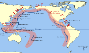
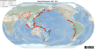
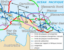
About 90%[2] of the world's earthquakes and about 81%[3] of the world's largest earthquakes occur along the Ring of Fire.[4][5] All but three of the world's 25 largest volcanic eruptions of the last 11,700 years occurred at volcanoes in the Ring of Fire.[6] The Ring of Fire is a direct result of plate tectonics: the movement and collisions of lithospheric plates,[7] especially subduction in the northern portion. The western portion is more complex, with a number of smaller tectonic plates in collision with the Pacific Plate from the Mariana Islands, the Philippines, Bougainville, Tonga, and New Zealand.
History
The presence of a belt of volcanic activity surrounding the Pacific Ocean was first observed in the mid 19th century. "They [the Japanese Islands] are in the line of that immense circle of volcanic development which surrounds the shores of the Pacific from Tierra del Fuego around to the Moluccas." (Matthew Perry, Narrative of the Expedition of an American Squadron to the China Seas and Japan, 1852–54, Introduction, Section I, "Name, Extent, and Geography")
About 90%[2] of the world's earthquakes and 81%[3] of the world's largest earthquakes occur along the Ring of Fire. The next most seismically active region (5–6% of earthquakes and 17% of the world's largest earthquakes) is Alpide belt, which extends from Java to the northern Atlantic Ocean via the Himalayas and southern Europe.[4][5]
All but three of the world's 25 largest volcanic eruptions of the last 11,700 years occurred at volcanoes in the Ring of Fire.[6]
The famous and very active San Andreas Fault zone of California is a transform fault, which offsets a portion of the East Pacific Rise under the southwestern United States and Mexico; the motion of the fault generates numerous small earthquakes, at multiple times a day, most of which are too small to be felt.[8][9]
The active Queen Charlotte Fault on the west coast of the Haida Gwaii, British Columbia, has generated three large earthquakes during the 20th century: a magnitude 7 event in 1929; a magnitude 8.1 in 1949 (Canada's largest recorded earthquake); and a magnitude 7.4 in 1970.[10]
Cause
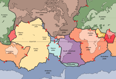
The Ring of Fire is a direct result of plate tectonics: the movement and collisions of lithospheric plates.[7] The eastern section of the ring is the result of the Nazca Plate and the Cocos Plate being subducted beneath the westward-moving South American Plate. The Cocos Plate is being subducted beneath the Caribbean Plate, in Central America. A portion of the Pacific Plate and the small Juan de Fuca Plate are being subducted beneath the North American Plate. Along the northern portion, the northwestward-moving Pacific Plate is being subducted beneath the Aleutian Islands arc. Farther west, the Pacific Plate is being subducted along the Kamchatka Peninsula arcs to the south past Japan. The southern portion is more complex, with a number of smaller tectonic plates in collision with the Pacific Plate from the Mariana Islands, the Philippines, Bougainville, Tonga, and New Zealand; this portion excludes Australia, since it lies in the center of its tectonic plate. Indonesia lies between the Ring of Fire along the northeastern islands adjacent to and including New Guinea and the Alpide belt along the south and west from Sumatra, Java, Bali, Flores, and Timor.[11]
Andes
Bolivia
Bolivia hosts numerous active and extinct volcanoes across its territory. The active volcanoes are located in western Bolivia where they make up the Cordillera Occidental, the western limit of the Altiplano plateau. Many of the active volcanoes are international mountains shared with Chile. All Cenozoic volcanoes of Bolivia are part of the Central Volcanic Zone (CVZ) of the Andean Volcanic Belt that results due to processes involved in the subduction of the Nazca Plate under the South American Plate. The Central Volcanic Zone is a major upper Cenozoic volcanic province.[12] Apart from Andean volcanoes, the geology of Bolivia hosts the remnants of ancient volcanoes around the Precambrian Guaporé Shield in the eastern part of the country.
Chile

The volcanoes in Chile are monitored by the National Geology and Mining Service (SERNAGEOMIN)[13][14]
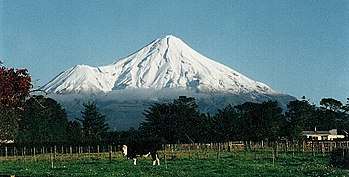
Earthquake activity in Chile is related to subduction of the Nazca Plate to the east. Chile notably holds the record for the largest earthquake ever recorded, the 1960 Valdivia earthquake. Villarrica, one of Chile's most active volcanoes, rises above Villarrica Lake and the town of Villarrica. It is the westernmost of three large stratovolcanoes that trend perpendicular to the Andean chain. A 6-kilometre-wide (3.7 mi) caldera formed during the late Pleistocene, more than 0.9 million years ago.
A 2-kilometre-wide (1.2 mi) postglacial caldera is located at the base of the presently active dominantly basaltic-to-andesitic cone at the northwest margin of the Pleistocene caldera. About 25 scoria cones dot Villarica's flanks. Plinian eruptions and pyroclastic flows have been produced during the Holocene from this dominantly basaltic volcano, but historical eruptions have consisted of largely mild-to-moderate explosive activity with occasional lava effusion. Lahars from the glacier-covered volcanoes have damaged towns on its flanks.
The Llaima Volcano is one of the largest and most active volcanoes in Chile. It is situated 82 km (51 mi) northeast of Temuco and 663 km (412 mi) southeast of Santiago, within the borders of Conguillío National Park. Llaima's activity has been documented since the 17th century, and consists of several separate episodes of moderate explosive eruptions with occasional lava flows. The last major eruption occurred in 1994.[15]
Chile has experienced numerous volcanic eruptions from 60 volcanoes, including Llaima Volcano and the Chaitén Volcano. More recently, a magnitude-8.8 earthquake struck central Chile on February 27, 2010, the Puyehue-Cordón Caulle volcano erupted in 2011, and a M8.2 earthquake struck northern Chile on April 1, 2014. The main shock was preceded by a number of moderate to large shocks and was followed by a large number of moderate to very large aftershocks, including a magnitude-7.6 event on 2 April.[16]
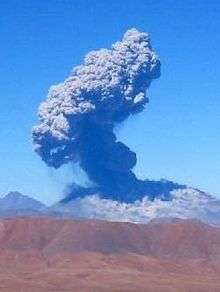
Lascar is a stratovolcano and the most active volcano of the northern Chilean Andes. The largest eruption of Lascar took place about 26,500 years ago, and following the eruption of the Tumbres scoria flow about 9,000 years ago, activity shifted back to the eastern edifice, where three overlapping craters were formed. Frequent small-to-moderate explosive eruptions have been recorded from Lascar in historical time since the mid-19th century, along with periodic larger eruptions that produced ash and tephra fall up to hundreds of kilometers away from the volcano.[17] The largest eruption of Lascar in recent history took place in 1993, producing pyroclastic flows as far as 8.5 km (5 mi) northwest of the summit and ash fall in Buenos Aires, Argentina,[17] more than 1,600 km (994 mi) to the southeast. The latest series of eruptions began on 18 April 2006 and was continuing as of 2011.
Chiliques is a stratovolcano located in the Antofagasta Region of Chile, immediately north of Cerro Miscanti. Laguna Lejía lies to the north of the volcano and has been dormant for at least 10,000 years, but is now showing signs of life. A January 6, 2002, nighttime thermal infrared image from ASTER revealed a hot spot in the summit crater, as well as several others along the upper flanks of the volcano's edifice, indicating new volcanic activity. Examination of an earlier nighttime thermal infrared image from May 24, 2000, showed no such hot spots.[18]
Calbuco is a stratovolcano in southern Chile, located southeast of Llanquihue Lake and northwest of Chapo Lake, in Los Lagos Region. The volcano and the surrounding area are protected within Llanquihue National Reserve. It is a very explosive andesite volcano that underwent edifice collapse in the late Pleistocene, producing a volcanic debris avalanche that reached the lake. At least nine eruptions occurred since 1837, with the latest one in 1972. One of the largest historical eruptions in southern Chile took place there in 1893–1894. Violent eruptions ejected 30 cm (12 in) bombs to distances of 8 km (5.0 mi) from the crater, accompanied by voluminous hot lahars. Strong explosions occurred in April 1917, and a lava dome formed in the crater accompanied by hot lahars. Another short explosive eruption in January 1929 also included an apparent pyroclastic flow and a lava flow. The last major eruption of Calbuco, in 1961, sent ash columns 12–15 km (7.5–9.3 mi) high and produced plumes that dispersed mainly to the southeast and two lava flows were also emitted. A minor, four-hour eruption happened on August 26, 1972. Strong fumarolic emission from the main crater was observed on August 12, 1996.
Lonquimay is a stratovolocano of late-Pleistocene to dominantly Holocene age, with the shape of a truncated cone. The cone is largely andesitic, though basaltic and dacitic rocks are present.[19] It is located in La Araucanía Region of Chile, immediately southeast of Tolhuaca volcano. Sierra Nevada and Llaima are their neighbors to the south. The snow-capped volcano lies within the protected area Malalcahuello-Nalcas. The volcano last erupted in 1988, ending in 1990. The VEI was 3. The eruption was from a flank vent and involved lava flows and explosive eruptions. Some fatalities occurred.[20]
Antuco Volcano is a stratovolocano located in the Bío Bío Region of Chile, near Sierra Velluda and on the shore of Laguna del Laja, with its last eruption in 1869.
Villarrica is one of Chile's most active volcanoes, rising above the lake and town of the same name. The volcano is also known as Rucapillán, a Mapuche word meaning "House of the Pillán". It is the westernmost of three large stratovolcanoes that trend perpendicular to the Andes along the Gastre Fault. Villarrica, along with Quetrupillán and the Chilean portion of Lanín, are protected within Villarrica National Park. Ascents of the volcano are popular with several guided ascents reaching the top during summer.
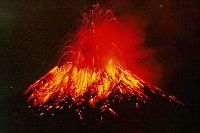
Villarrica, with its lava of basaltic-andesitic composition, is one of only five volcanoes worldwide known to have an active lava lake within its crater. The volcano usually generates strombolian eruptions, with ejection of incandescent pyroclasts and lava flows. Melting of snow and glacier ice, as well as rainfall, often causes massive lahars, such as during the eruptions of 1964 and 1971.[21]
Ecuador
In Ecuador, EPN monitors the volcanic activity in this andean nation.
Cotopaxi is a stratovolcano in the Andes, located about 50 km (31 mi) south of Quito, Ecuador, South America.[22] It is the second-highest summit in the country, reaching a height of 5,897 m (19,347 ft). Some consider it the world's highest active volcano,[23] and it is one of Ecuador's most active volcanoes. Since 1738, Cotopaxi has erupted more than 50 times, resulting in the creation of numerous valleys formed by mudflows around the volcano.
In October 1999, Pichincha Volcano erupted in Quito and covered the city with several inches of ash. Prior to that, the last major eruptions were in 1553[24] and in 1660, when about 30 cm of ash fell on the city.[25]
At 5,230-metre (17,160 ft), Sangay Volcano[26] is an active stratovolcano in central Ecuador, one of the highest active volcanoes in the world, and one of Ecuador's most active ones, having erupted three times in recorded history. It exhibits mostly strombolian activity; the most recent eruption, which started in 1934, is still going on. Geologically, Sangay marks the southern bound of the Northern Volcanic Zone, and its position straddling two major pieces of crust accounts for its high level of activity. Sangay's roughly 500,000-year history is one of instability; two previous versions of the mountain were destroyed in massive flank collapses, evidence of which still litters its surroundings today. Sangay is one of two active volcanoes located within the namesake Sangay National Park, the other being Tungurahua to the north. As such, it has been listed as a UNESCO World Heritage Site since 1983.
Reventador is an active stratovolcano that lies in the eastern Andes of Ecuador. Since 1541, it has erupted over 25 times, with its most recent eruption in 2009,[27] but the largest historical eruption occurred in 2002. During that eruption, the plume from the volcano reached a height of 17 km (11 mi), and pyroclastic flows went up to 7 km (4.3 mi) from the cone. On March 30, 2007, the mountain spewed ash again. The ash reached a height of about 3.2 km (2 mi).
Cotopaxi, outside of Quito, started activity in April 2015. A large increase in earthquakes (including harmonic tremors) and SO2 emissions began. IGPEN reported slight deformation of the edifice, suggesting an intrusion of magma under the volcano. As of 25 July, the unrest continued, and the most recent major eruption was an ash and steam eruption that occurred on August 14 and 15, 2015.[28][29][30][31][32]
Peru
Volcanoes in Peru are monitored by the Peruvian Geophysical Institute.[33]
Sabancaya is an active 5,976-metre (19,606 ft) stratovolcano in the Andes of southern Peru, about 100 km (62 mi) northwest of Arequipa. It is the most active volcano in Peru, with an ongoing eruption that started in August 2014.
Ubinas is another active volcano of 5,672-metre (18,609 ft) in southern Peru with an ongoing eruption.[34][35] Until 2006, this stratovolcano had not erupted for about 40 years. On April 23, 2006, Peru declared a state of emergency in towns near the volcano. On April 28, 2014, despite a recent decline in earthquakes, Ubinas Volcano erupted an ash plume.[36][37]
Central America
Costa Rica
The Volcanological and Seismological Observatory of Costa Rica (OVSICORI, Observatorio Vulcanológico y Sismológico de Costa Rica) at the National University of Costa Rica[38] has a dedicated team in charge of researching and monitoring the volcanoes, earthquakes, and other tectonic processes in the Central America Volcanic Arc. In 1984, the OVSICORI-A initiated the operation of a seismographic network designed to monitor seismic and volcanic activity throughout the national territory. Currently, the seismographic network has an analog and a digital registration system. The latter enables online analysis of seismic signals, allowing to expedite the analysis of signals and the study using modern computerized methods. Poás Volcano is an active 2,708-metre (8,885 ft) stratovolcano located in central Costa Rica; it has erupted 39 times since 1828. On February 25, 2014, a webcam from the OVSICORI captured the moment a dark cloud exploded about 1,000 feet (300 m) in the air from a massive crater of the Poás Volcano.[39][40][41]
Guatemala
In 1902, the Santa Maria Volcano erupted violently in Guatemala, with the largest explosions occurring over two days, ejecting an estimated 5.5 km3 (1.3 cu mi) of magma. The eruption was one of the largest of the 20th century, only slightly less in magnitude to that of Mount Pinatubo in 1991. The eruption had a volcanic explosivity index of 6. Today, Santiaguito is one of the world's most active volcanoes. Santa Maria and Santiaguito, Guatemala Santiaguito
North American Cordillera
Mexico
Volcanoes of Mexico are related to subduction of the Cocos and Rivera Plates to the east, which has produced large, explosive eruptions. Most active volcanoes in Mexico occur in the Trans-Mexican Volcanic Belt, which extends 900-kilometre (560 mi) from west to east across central-southern Mexico. A few other active volcanoes in northern Mexico are related to extensional tectonics of the Basin and Range Province, which splits the Baja California peninsula from the mainland.[42] Popocatépetl, lying in the eastern half of the Trans-Mexican Volcanic Belt, is the second-highest peak in Mexico after the Pico de Orizaba. It is one of the most active volcanoes in Mexico, having had more than 20 major eruptions since the arrival of the Spanish in 1519. The 1982 eruption of El Chichón, which killed about 2,000 people who lived near the volcano, created a 1-km-wide caldera that filled with an acidic crater lake. Before 1982, this relatively unknown volcano was heavily forested and of no greater height than adjacent nonvolcanic peaks.[42]
United States
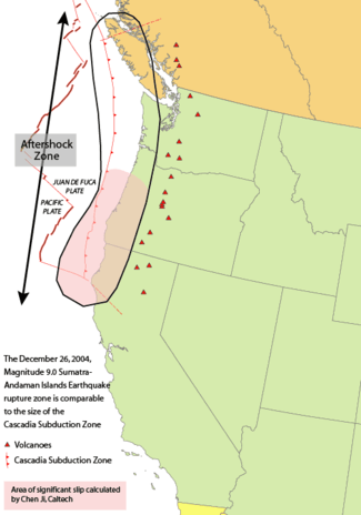
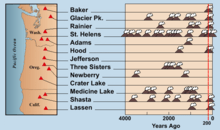
The United States Geological Survey and the National Earthquake Information Center (NEIC) are located on the campus of the Colorado School of Mines in Golden, Colorado. Both monitor volcanos in the United States; in the western United States lies the Cascade Volcanic Arc. It includes nearly 20 major volcanoes, among a total of over 4,000 separate volcanic vents including numerous stratovolcanoes, shield volcanoes, lava domes, and cinder cones, along with a few isolated examples of rarer volcanic forms such as tuyas. Volcanism in the arc began about 37 million years ago, but most of the present-day Cascade volcanoes are less than 2,000,000 years old, and the highest peaks are less than 100,000 years old. The arc is formed by the subduction of the Gorda and Juan de Fuca Plates at the Cascadia subduction zone. This is a 1,090-kilometre (680 mi) long fault, running 80 km (50 mi) off the coast of the Pacific Northwest from northern California to Vancouver Island, British Columbia. The plates move at a relative rate of over 10 mm (0.4 in) per year at a somewhat oblique angle to the subduction zone.
Because of the very large fault area, the Cascadia subduction zone can produce very large earthquakes, magnitude 9.0 or greater, if rupture occurred over its whole area. When the "locked" zone stores energy for an earthquake, the "transition" zone, although somewhat plastic, can rupture. Thermal and deformation studies indicate that the locked zone is fully locked for 60 km (37 mi) down-dip from the deformation front. Further down-dip, a transition from fully locked to aseismic sliding occurs.
Unlike most subduction zones worldwide, no oceanic trench is present along the continental margin in Cascadia. Instead, terranes and the accretionary wedge have been lifted up to form a series of coast ranges and exotic mountains. A high rate of sedimentation from the outflow of the three major rivers (Fraser River, Columbia River, and Klamath River) which cross the Cascade Range contributes to further obscuring the presence of a trench. However, in common with most other subduction zones, the outer margin is slowly being compressed, similar to a giant spring. When the stored energy is suddenly released by slippage across the fault at irregular intervals, the Cascadia subduction zone can create very large earthquakes such as the magnitude-9 Cascadia earthquake of 1700. Geological evidence indicates that great earthquakes may have occurred at least seven times in the last 3,500 years, suggesting a return time of 400 to 600 years. Also, evidence of accompanying tsunamis with every earthquake is seen, as the prime reason these earthquakes are known is through "scars" the tsunami left on the coast, and through Japanese records (tsunami waves can travel across the Pacific).
The 1980 eruption of Mount St. Helens was the most significant to occur in the contiguous 48 U.S. states in recorded history (VEI = 5, 1.3 km3 (0.3 cu mi) of material erupted), exceeding the destructive power and volume of material released by the 1915 eruption of California's Lassen Peak. The eruption was preceded by a two-month series of earthquakes and steam-venting episodes caused by an injection of magma at shallow depth below the mountain that created a huge bulge and a fracture system on Mount St. Helens' north slope. An earthquake at 8:32 am on May 18, 1980, caused the entire weakened north face to slide away, suddenly exposing the partly molten, gas- and steam-rich rock in the volcano to lower pressure. The rock responded by exploding into a very hot mix of pulverized lava and older rock that sped toward Spirit Lake so fast that it quickly passed the avalanching north face.
Alaska is known for its seismic and volcanic activity, holding the record for the second-largest earthquake in the world, the Good Friday earthquake, and having more than 50 volcanoes which have erupted since about 1760.[43] Volcanoes can be found not only in the mainland, but also in the Aleutian Islands.
The most recent activity in the American portion of the Ring of Fire occurred in early 2009 when Mount Redoubt in Alaska became active and finally erupted late in the evening of March 22. The eruption ended in May 2009.
Canada
The Public Safety Geo-science Program at the Natural Resources Canada undertakes research to support risk reduction from the effects of space weather, earthquakes, tsunamis, volcanoes, and landslides.[44]
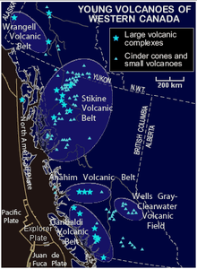
British Columbia and Yukon are home to a vast region of volcanoes and volcanic activity in the Pacific Ring of Fire.[45] Several mountains in populated areas of British Columbia are dormant volcanoes. Most of these were active during the Pleistocene and Holocene epochs. Although none of Canada's volcanoes are currently erupting, several volcanoes, volcanic fields, and volcanic centers are considered potentially active.[46] Hot springs are at some volcanoes, while 10 volcanoes in British Columbia appear related to seismic activity since 1975, including: the Silverthrone Caldera, Mount Meager massif, Wells Gray-Clearwater volcanic field, Mount Garibaldi, Mount Cayley massif, Castle Rock, The Volcano, Mount Edziza, Hoodoo Mountain, Crow Lagoon, and Nazko Cone.[47] The volcanoes are grouped into five volcanic belts with different tectonic settings.
The Northern Cordilleran Volcanic Province (sometimes known as the Stikine Volcanic Belt) is the most active volcanic region in Canada. It formed due to extensional cracking, faulting, and rifting of the North American Plate as the Pacific Plate grinds and slides past the Queen Charlotte Fault, unlike subduction that produces the volcanoes in Japan, the Philippines, and Indonesia. The region has Canada's largest volcanoes,[45] much larger than the minor stratovolcanoes found in the Canadian portion of the Cascade Volcanic Arc.[45] Several eruptions are known to have occurred within the last 400 years. Mount Edziza is a huge volcanic complex that erupted several times in the past several thousand years and has formed several cinder cones and lava flows. The complex comprises the Mount Edziza Plateau, a large volcanic plateau (65 km long and 20 km wide) made of predominantly basaltic lava flows with four large stratovolcanoes built on top of the plateau. The associated lava domes and satellite cones were constructed over the past 7.5 million years during five magmatic cycles beginning with eruption of alkali basalts and ending with felsic and basaltic eruptions as late as 1,340 years ago. The blocky lava flows still maintain their original forms. Hoodoo Mountain is a tuya in northwestern British Columbia, which has had several periods of subglacial eruptions. The oldest eruptions occurred about 100,000 years ago and the most recent about 7000 years ago. Hoodoo Mountain is also considered active, so it could erupt in the future. The nearby Tseax Cone and The Volcano produced some of Canada's youngest lava flows, about 150 years old.

Canada's worst known geophysical disaster came from the Tseax Cone during the 18th century at the southernmost end of the volcanic belt. The eruption produced a 22.5-km-long lava flow, destroying the Nisga'a villages and the death of at least 2000 Nisga'a people by volcanic gases and poisonous smoke. The Nass River valley was inundated by the lava flows and contains abundant tree molds and lava tubes. The event happened at the same time as the arrival of the first European explorers to penetrate the uncharted coastal waters of northern British Columbia. Today, the basaltic lava deposits are a draw to tourists and are part of the Nisga'a Memorial Lava Beds Provincial Park.
The Garibaldi Volcanic Belt in southwestern British Columbia is the northern extension of the Cascade Volcanic Arc in the United States (which includes Mount Baker and Mount St. Helens) and contains the most explosive young volcanoes in Canada.[48] It formed as a result of subduction of the Juan de Fuca Plate (a remnant of the much larger Farallon Plate) under the North American Plate along the Cascadia subduction zone.[48] The Garibaldi Volcanic Belt includes the Bridge River Cones, Mount Cayley massif, Mount Fee, Mount Garibaldi, Mount Price, Mount Meager massif, the Squamish Volcanic Field, and more smaller volcanoes. The eruption styles in the belt range from effusive to explosive, with compositions from basalt to rhyolite. Morphologically, centers include calderas, cinder cones, stratovolcanoes and small isolated lava masses. Due to repeated continental and alpine glaciations, many of the volcanic deposits in the belt reflect complex interactions between magma composition, topography, and changing ice configurations. The most recent major catastrophic eruption in the Garibaldi Volcanic Belt was an explosive eruption of the Mount Meager massif about 2,350 years ago. It was similar to the 1980 eruption of Mount St. Helens,[48] sending an ash column about 20 km into the stratosphere.[49]

The Chilcotin Group is a north-south range of volcanoes in southern British Columbia running parallel to the Garibaldi Volcanic Belt. The majority of the eruptions in this belt happened either 6–10 million years ago (Miocene) or 2–3 million years ago (Pliocene), although with some slightly more recent eruptions (in the Pleistocene).[50] It is thought to have formed as a result of back-arc extension behind the Cascadia subduction zone.[50] Volcanoes in this belt include Mount Noel, the Clisbako Caldera Complex, Lightning Peak, Black Dome Mountain, and many lava flows.
The Anahim Volcanic Belt is a line of volcanoes stretching from just north of Vancouver Island to near Quesnel, British Columbia. These volcanoes were formed 8 to 1 million years ago, and the Nazko Cone last erupted only 7,200 years ago.[51] The volcanoes generally get younger moving from the coast to the interior. These volcanoes are thought to have formed as a result of the North American Plate sliding westward over a small hotspot, called the Anahim hotspot.[51] The hotspot is considered similar to the one feeding the Hawaiian Islands.[51] The belt is defined by three large shield volcanoes (Rainbow, Ilgachuz and the Itcha Ranges) and 37 Quaternary basalt centers.
Eruptions of basaltic to rhyolitic volcanoes and hypabyssal rocks of the Alert Bay Volcanic Belt in northern Vancouver Island are probably linked with the subducted margin flanked by the Explorer and Juan de Fuca Plates at the Cascadia subduction zone. It appears to have been active during the Pliocene and Pleistocene. However, no Holocene eruptions are known, and volcanic activity in the belt has likely ceased.
Russia
The Kamchatka Peninsula in the Russian Far East is one of the most various and active volcanic areas in the world,[52] with an area of 472,300 km2 (182,400 sq mi). It lies between the Pacific Ocean to the east and the Okhotsk Sea to the west. Immediately offshore along the Pacific coast of the peninsula runs the 10,500-metre-deep (34,400 ft) Kuril-Kamchatka Trench, where rapid subduction of the Pacific Plate fuels the intense volcanism. Almost all types of volcanic activity are present, from stratovolcanoes and shield volcanoes to Hawaiian-style fissure eruptions.[52]
Over 30 active volcanoes and hundreds of dormant and extinct volcanoes are in two major volcanic belts. The most recent activity takes place in the eastern belt,[52] starting in the north at the Shiveluch volcanic complex, which lies at the junction of the Aleutian and Kamchatka volcanic arcs. Just to the south is the famous Klyuchi volcanic group, comprising the twin volcanic cones of Kliuchevskoi and Kamen, the huge volcanic complexes of Tolbachik and Ushkovsky, and a number of other large stratovolcanoes. The only active volcano in the central belt is found west of here, the huge remote Ichinsky. Farther south, the eastern belt continues to the southern slope of Kamchatka, topped by loads of stratovolcanoes, continuing onto the Kuril Islands with about 40 active volcanoes, and south into Japan.
Japan
About 10% of the world's active volcanoes are found in Japan, which lies in a zone of extreme crustal instability. They are formed by subduction of the Pacific Plate and the Philippine Sea Plate. As many as 1,500 earthquakes are recorded yearly, and magnitudes of 4 to 6 are not uncommon. Minor tremors occur almost daily in one part of the country or another, causing some slight shaking of buildings. Major earthquakes occur infrequently; the most famous in the 20th century were: the Great Kantō earthquake of 1923, in which 130,000 people died; and the Great Hanshin earthquake of 17 January 1995, in which 6,434 people died. On March 11, 2011 a magnitude 9.0 earthquake hit Japan, the country's biggest ever and the fifth largest on record, according to US Geological Survey data.[53] Undersea earthquakes also expose the Japanese coastline to danger from tsunamis.
Mount Bandai, one of Japan's most noted volcanoes, rises above the north shore of Lake Inawashiro. Mount Bandai is formed of several overlapping stratovolcanoes, the largest of which is O-Bandai forming a complex volcano. O-Bandai volcano was constructed within a horseshoe-shaped caldera that formed about 40,000 years when an earlier volcano collapsed, forming the Okinajima debris avalanche, which traveled to the southwest and was accompanied by a plinian eruption. Four major phreatic eruptions have occurred during the past 5,000 years, two of them in historical time, in 806 and 1888. Seen from the south, Bandai presents a conical profile, but much of the north side of the volcano is missing as a result of the collapse of Ko-Bandai volcano during the 1888 eruption, in which a debris avalanche buried several villages and formed several large lakes.
In July 1888, the north flank of Mount Bandai collapsed during an eruption quite similar to the May 18, 1980, eruption of Mount St. Helens. After a week of seismic activity, a large earthquake on July 15, 1888, was followed by a tremendous noise and a large explosion. Eyewitnesses heard about 15 to 20 additional explosions and observed that the last one was projected almost horizontally to the north.
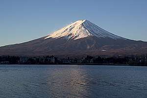
Mount Fuji is Japan's highest and most noted volcano, featuring heavily in Japanese culture and serving as one of the country's most popular landmarks. The modern postglacial stratovolcano is constructed above a group of overlapping volcanoes, remnants of which form irregularities on Fuji's profile. Growth of the younger Mount Fuji began with a period of voluminous lava flows from 11,000 to 8,000 years ago, accounting for four-fifths of the volume of the younger Mount Fuji. Minor explosive eruptions dominated activity from 8,000 to 4,500 years ago, with another period of major lava flows occurring from 4,500 to 3,000 years ago. Subsequently, intermittent major explosive eruptions occurred, with subordinate lava flows and small pyroclastic flows. Summit eruptions dominated from 3,000 to 2,000 years ago, after which flank vents were active. The extensive basaltic lava flows from the summit and some of the more than 100 flank cones and vents blocked drainage against the Tertiary Misaka Mountains on the north side of the volcano, forming the Fuji Five Lakes and the volcanic rock which the Aokigahara forest has grown on. The last eruption of this dominantly basaltic volcano in 1707 ejected andesitic pumice and formed a large new crater on the east flank. Some minor volcanic activity may occur in the next few years.
Philippines
The 1991 eruption of Mount Pinatubo is the world's second-largest terrestrial eruption of the 20th century. Successful predictions of the onset of the climactic eruption led to the evacuation of tens of thousands of people from the surrounding areas, saving many lives, but as the surrounding areas were severely damaged by pyroclastic flows, ash deposits, and later, lahars caused by rainwater remobilising earlier volcanic deposits, thousands of houses were destroyed.
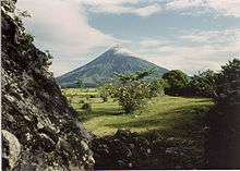
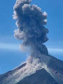
Mayon Volcano is the Philippines' most active volcano. It has steep upper slopes that average 35–40° and is capped by a small summit crater. The historical eruptions of this basaltic-andesitic volcano date back to 1616 and range from Strombolian to basaltic Plinian eruptions. Eruptions occur predominately from the central conduit and have also produced lava flows that travel far down the flanks. Pyroclastic flows and mudflows have commonly swept down many of the roughly 40 ravines that radiate from the summit and have often devastated populated lowland areas.
Taal Volcano has had 33 recorded eruptions since 1572. A devastating eruption occurred in 1911, which claimed more than a thousand lives. The deposits of that eruption consist of a yellowish, fairly decomposed (nonjuvenile) tephra with a high sulfur content. The most recent period of activity lasted from 1965 to 1977, and was characterized by the interaction of magma with the lake water, which produced violent phreatic and phreatomagmatic eruptions. Although the volcano has been dormant since 1977, it has shown signs of unrest since 1991, with strong seismic activity and ground-fracturing events, as well as the formation of small mud geysers on parts of the island.
Kanlaon Volcano, the most active volcano in the central Philippines, has erupted 25 times since 1866. Eruptions are typically phreatic explosions of small-to-moderate size that produce minor ash falls near the volcano. On August 10, 1996, Kanlaon erupted without warning, killing British student Julian Green and Filipinos Noel Tragico and Neil Perez, who were among 24 mountain climbers who were trapped near the summit.
Indonesia

The volcanoes in Indonesia are among the most active of the Pacific Ring of Fire. They are formed due to subduction zones of three main active tectonic plates, namely the Eurasian Plate, Pacific Plate, and Indo-Australian Plate.[54] Some of the volcanoes are notable for their eruptions, for instance, Krakatau for its global effects in 1883, Lake Toba for its supervolcanic eruption estimated to have occurred 74,000 BP, which was responsible for six years of volcanic winter, and Mount Tambora, for the most violent eruption in recorded history in 1815. The eruption of Mount Tambora caused widespread harvest failures in Northern Europe, the Northeastern United States, and eastern Canada in 1816, which was known as the Year Without a Summer.
The most active volcanoes are Kelud and Mount Merapi on Java island, which have been responsible for thousands of deaths in the region. Since AD 1000, Kelud has erupted more than 30 times, of which the largest eruption was at scale 5 on the Volcanic Explosivity Index, while Merapi has erupted more than 80 times. The International Association of Volcanology and Chemistry of the Earth's Interior has named Merapi as a Decade Volcano since 1995 because of its high volcanic activity. Another active volcano is Sinabung, which has been erupting since 2013.
New Zealand
New Zealand contains the world's strongest concentration of youthful rhyolitic volcanoes, and voluminous sheets blanket much of the North Island. The earliest historically-dated eruption was at Whakaari/White Island in 1826,[55] followed in 1886 by the country's largest historical eruption at Mount Tarawera. Much of the region north of New Zealand's North Island is made up of seamounts and small islands, including 16 submarine volcanoes. In the last 1.6 million years, most of New Zealand's volcanism is from the Taupo Volcanic Zone.[56]
Mount Ruapehu, at the southern end of the Taupo Volcanic Zone, is one of the most active volcanoes.[57] It began erupting at least 250,000 years ago. In recorded history, major eruptions have been about 50 years apart,[57] in 1895, 1945, and 1995–1996. Minor eruptions are frequent, with at least 60 since 1945. Some of the minor eruptions in the 1970s generated small ash falls and lahars that damaged ski fields.[58] Between major eruptions, a warm acidic crater lake forms, fed by melting snow. Major eruptions may completely expel the lake water. Where a major eruption has deposited a tephra dam across the lake's outlet, the dam may collapse after the lake has refilled and risen above the level of its normal outlet, the outrush of water causing a large lahar. The most notable lahar caused the Tangiwai disaster on December 24, 1953, when 151 people aboard a Wellington to Auckland express train were killed after the lahar destroyed the Tangiwai rail bridge just moments before the train was due. In 2000, the ERLAWS system was installed on the mountain to detect such a collapse and alert the relevant authorities.
The Auckland volcanic field on the North Island of New Zealand has produced a diverse array of explosive craters, scoria cones, and lava flows. Currently dormant, the field is likely to erupt again with the next "hundreds to thousands of years", a very short timeframe in geologic terms.[59] The field contains at least 40 volcanoes, most recently active about 600 years ago at Rangitoto Island, erupting 2.3 km3 (0.55 cu mi) of lava.
Antarctica
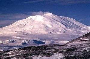
The Pacific Ring of Fire is completed in the south by the continent of Antarctica,[60][61] which includes many large volcanoes. The makeup and structure of the volcanoes in Antarctica change largely from the other places around the ring. In contrast, the Antarctic Plate is almost completely surrounded by extensional zones, with several mid-ocean ridges that encircle it, with only a small subduction zone at the tip of the Antarctic Peninsula, reaching eastward to the remote South Sandwich Islands.[61] The most well-known volcano in Antarctica is Mount Erebus, which is also the world's southernmost active volcano.[61] In many respects the geology of the Antarctic Peninsula is an extension of the Andes, hence the name sometimes used by geologists: "Antarctandes". At the opposite side of the continent, the volcanoes of Victoria Land may be seen as the 'other end' of the Antarctandes, thus completing the Pacific Ring of Fire and continuing up through the Balleny Islands to New Zealand.
Mount Erebus is the second-highest volcano in Antarctica (after Mount Sidley) and the southernmost active volcano on earth. It is the sixth-highest ultra mountain on an island.[17] With a summit elevation of 3,794 m (12,448 ft), it is located on Ross Island, which is also home to three inactive volcanoes, Mount Terror, Mount Bird, and Mount Terra Nova.
The volcano has been observed to be continuously active[62] since 1972 and is the site of the Mount Erebus Volcano Observatory, run by the New Mexico Institute of Mining and Technology.[63] Mount Erebus is currently the most active volcano in Antarctica and is the current eruptive zone of the Erebus hotspot.
The volcanoes of the Victoria Land area are the most well known in Antarctica,[61] most likely because they are the most accessible. Much of Victoria Land is mountainous, developing the eastern section of the Transantarctic Mountains, and the several scattered volcanoes include Mount Overlord and Mount Melbourne in the northern part.[61] Farther south are two more well-known volcanoes, Mount Discovery and Mount Morning, which are on the coast across from Mount Erebus and Mount Terror on Ross Island. The volcanism in this area is caused by rifting along a number of rift zones increasing mainly north-south similar to the coast.[61]
Marie Byrd Land contains the largest volcanic region in Antarctica, covering a length of almost 600 mi (970 km) along the Pacific coast.[61] The volcanism is the result of rifting along the vast West Antarctic Rift System, which extends from the base of the Antarctic Peninsula to the surrounding area of Ross Island, and the volcanoes are found along the northern edge of the rift.[61] Protruding up through the ice are a large number of major shield volcanoes, including Mount Sidley, which is the highest volcano in Antarctica.[61] Although a number of the volcanoes are relatively young and are potentially active (Mount Berlin, Mount Takahe, Mount Waesche, and Mount Siple), others such as Mount Andrus and Mount Hampton are over 10 million years old yet maintain uneroded constructional forms.[61] The desert-like surroundings of the Antarctic interior, along with a very thick and stable ice sheet which encloses and protects the bases of the volcanoes, which decreases the speed of erosion by an issue of perhaps a thousand relative to volcanoes in moist temperate or tropical climates.
Land areas
- Puysegur Trench and
Macquarie Ridge - Taupo Volcanic Zone
- Kermadec Islands
- Tonga Islands
- Fiji Islands
- Bougainville and Solomon Islands
- New Hebrides Arc
- Bismarck Volcanic Arc, junction
- Tanimbar and Kai Islands
- Lesser Sunda Islands
- Sunda Arc
- Andaman and Nicobar Islands
- Izu-Bonin-Mariana Arc
- Philippine Mobile Belt
- Taiwan
- Ryukyu Islands
- Japan, Boso Triple Junction
- Kuril Islands
- Kamchatka Peninsula
- American Cordillera
- North American Cordillera
- Aleutian Arc
- Eastern Alaska, U.S.
- Northern Cordilleran Volcanic Province
- Cascade Volcanic Arc and
Rio Grande rift - Sierra Nevada (U.S.)
- Trans-Mexican Volcanic Belt
- Central America Volcanic Arc
- Andes
- North Volcanic Zone
- Central Volcanic Zone
- South Volcanic Zone
- Austral Volcanic Zone
- North American Cordillera
- Scotia Arc
- South Sandwich Islands
- Antarctica
See also
References
- "Ring of Fire – Pacific Ring of Fire". Geography.about.com. 2010-06-14. Retrieved 2010-11-01.
- "Ring of Fire". USGS. 2012-07-24. Retrieved 2013-06-13.
- "Where do earthquakes occur?". USGS. 2013-05-13. Archived from the original on 2014-08-05. Retrieved 2013-06-13.
- "Earthquakes FAQ". U.S. Geological Survey. Archived from the original on 2006-01-17.
- "Earthquakes Visual Glossary". U.S. Geological Survey.
- Oppenheimer, Clive (2011). "Appendix A". Eruptions that Shook the World. Cambridge: Cambridge University Press. pp. 355–363. ISBN 978-0-521-64112-8.
- "Moving slabs". This Dynamic Earth. USGS.
- "Latest Earthquakes in the USA". USGS.
- Schulz, Sandra S.; Wallace, Robert E. "The San Andreas Fault". USGS.
- "Earthquakes in the Queen Charlotte Islands Region 1984–1996". Archived from the original on 2006-04-18. Retrieved 2007-10-03.CS1 maint: BOT: original-url status unknown (link)
- Nicole Chavez. "Why Indonesia has so many earthquakes". CNN.
- Baker, M.C.W.; Francis, P.W. (1978). "Upper Cenozoic Volcanism in the Central Andes – Ages and Volumes". Earth and Planetary Science Letters. 41 (2): 175–187. Bibcode:1978E&PSL..41..175B. doi:10.1016/0012-821X(78)90008-0.
- "Red de vigilancia volcánica – Sernageomin". sernageomin.cl. Archived from the original on 2016-11-28.
- USGS. "VDAP Responses at Chaitén in Chile". usgs.gov. Archived from the original on 2014-12-10.
- "Chile volcano forces evacuations". BBC. January 2, 2008.
- "Magnitude 8.8 – OFFSHORE MAULE, CHILE". February 27, 2010. Archived from the original on 2010-04-10. Retrieved February 28, 2010.
- "Mount Erebus". Global Volcanism Program. Smithsonian Institution. Retrieved 2008-12-29.
- "Chiliques Volcano, Chile". Visible Earth. NASA. Retrieved 2007-03-24.
- "Global Volcanism Program – Lonquimay". si.edu.
- "Global Volcanism Program – Lonquimay". si.edu.
- La erupción de 1971, Villarrica Volcano Visual Observation Project. 2008.
- "Distance from Quito to Cotopaxi". distancecalculator.globefeed.com.
- "Cotopaxi". Encyclopædia Britannica.
- Climate and Weather, Kington, J. Collins London, (2010)
- "Ecuadoreans Wait Uneasily on Volcanoes". Associated Press. 28 November 1999 – via The New York Times.
- "Sangay: Synonyms and subfeatures". Global Volcanism Program. Smithsonian National Museum of Natural History. Retrieved 5 February 2012.
- "Reventador volcano spews lava near Ecuador capital". Associated Press. Archived from the original on 2016-05-03.
- "A Restless Volcano Puts Ecuador on Edge Once More". WIRED. 17 June 2015.
- http://www.igepn.edu.ec/cotopaxi National Polytechnic School Geophysics Institute is constantly monitoring Cotopaxi
- "Ecuador declares state of emergency over volcano". BBC News. BBC.com. 2015-08-16.
- "Cotopaxi volcano (Ecuador): increased seismic activity, volcanic unrest". volcanodiscovery.com.
- "15 sitios seguros en el Distrito Metropolitano de Quito por el Cotopaxi". El Comercio.
- "Portal | Instituto Geofísico del Perú". portal.igp.gob.pe.
- "Ubinas". Smithsonian Institution.
- "Ubinas". volcanodiscovery.com.
- "Fresh Lava Arrives at Ubinas Volcano : Natural Hazards". NASA. 2014-05-03.
- "Peru evacuates Ubinas volcano area after ash cloud". BBC.
- "Observatorio Vulcanológico y Sismológico de Costa Rica (OVSICORI)". National University of Costa Rica.
- "Poás Volcano Erupts in Central Costa Rica". New York Daily News.
- "Volcano Tourists in Costa Rica Enjoy Phreatic Eruption". October 13, 2014.
- "Despite Record Breaking Eruptions at Poas Volcano the Park Remains Open for Visitors to Enjoy". 2014-10-16. Archived from the original on December 5, 2014. Retrieved December 5, 2014.
- "Mexico Volcanoes and Volcanics". USGS. Archived from the original on 2005-03-09. Retrieved 2007-10-14.
- "Alaska Volcano Observatory – About Alaska's Volcanoes". Avo.alaska.edu. Retrieved 2010-11-01.
- "Public Safety Geoscience Program". Natural Resources Canada. 2013-10-29.
- "Skiing the Pacific Ring of Fire and Beyond: Alaska and Northwest Canada". Retrieved 2007-07-31.
- "Canadian volcanoes". CAT.INIST. Retrieved 2007-07-31.
- "Volcanoes of Canada" (PDF). Archived from the original (PDF) on 2006-05-28. Retrieved 2007-06-24.
- "Garibaldi Volcanic Belt". Calalogue of Canadian volcanoes. Archived from the original on 2006-02-19. Retrieved 2007-07-31.
- "Mount Meager". Catalogue of Canadian volcanoes. Archived from the original on 2006-02-19. Retrieved 2007-07-31.
- "Chilcotin Plateau basalts". Catalogue of Canadian volcanoes. Archived from the original on 2008-03-15. Retrieved 2007-07-31.
- "Anahim Volcanic Belt". Catalogue of Canadian volcanoes. Archived from the original on 2006-02-19. Retrieved 2007-07-31.
- Skiing the Pacific Ring of Fire and Beyond: Kamchatka & Kuril Islands Retrieved on 2007-08-01
- "LIST: Japan quake seventh largest in history". Smh.com.au. 2011-03-11. Retrieved 2011-03-19.
- "RI sits on Pacific "ring of fire" : official". Antara News.
- "New Zealand Volcanoes and Volcanics". USGS CVO. Archived from the original on 2005-12-23. Retrieved 2007-10-15.
- "GeoNet". New Zealand.
- New Zealand Department of Conservation. "Crater Lake Climb". Retrieved 2006-10-23.
- New Zealand Department of Conservation. "Central North Island Volcanoes". Archived from the original on 2010-12-29. Retrieved 2006-10-23.
- "Contingency Plan for the Auckland Volcanic Field" (PDF). Auckland Regional Council. Archived from the original (PDF) on 2006-01-16.
- nationalgeographic.org, Plate Tectonics and the Ring of Fire
- Skiing the Pacific Ring of Fire and Beyond: Antarctica. Retrieved 2007-07-31.
- "Erebus". Smithsonian Institution National Museum of Natural History Global Volcanism Program.
- "Mount Erebus Volcano Observatory". New Mexico Tech. Archived from the original on 2007-07-02. Retrieved 2008-12-29.
External links
| Wikimedia Commons has media related to Maps of the Pacific Ring of Fire. |
- Historic Earthquakes & Earthquake Statistics at the United States Geological Survey
- DESCRIPTION: "Ring of Fire", Plate Tectonics, Sea-Floor Spreading, Subduction Zones, "Hot Spots" at the USGS Cascades Volcano Observatory, Vancouver, Washington Web site.
- Map of the Ring of Fire
- Ring of Fire, tectonic activity
- The Ring of Fire at work
- Physical World Map 2004-04-01 CIA World Factbook; Robinson Projection; standard parallels 38°N and 38°S