Land and water hemispheres
The land and water hemispheres of Earth, sometimes capitalised as the Land Hemisphere and Water Hemisphere, are the hemispheres of Earth containing the largest possible total areas of land and ocean, respectively. By definition (assuming that the entire surface can be classed as either "land" or "ocean"), the two hemispheres do not overlap.
Determinations of the hemispheres vary slightly. One determination places the centre of the Land Hemisphere at 47°13′N 1°32′W (in the city of Nantes, France).[1] The centre of the Water Hemisphere is the antipode of the centre of the Land Hemisphere, and is therefore located at 47°13′S 178°28′E (near New Zealand's Bounty Islands in the Pacific Ocean).[1]
An alternative assignment determines the centre of the Land Hemisphere to be at 47°24′42″N 2°37′15″W (in Dumet Island near Piriac-sur-Mer, France).[2][3] The centre of the Water Hemisphere is located at 47°24′42″S 177°22′45″E (again near New Zealand's Bounty Islands in the Pacific Ocean).
Distribution of geographical features
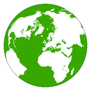
The Land Hemisphere has the substantial majority of the planet's land (80.1%), including most of South America and nearly all of Asia (with Maritime Southeast Asia being the only notable exception). Africa, Europe and North America are solely within the Land Hemisphere. However, even in the Land Hemisphere, the ocean area still slightly exceeds the land area (about 53% ocean and 47% land). The Land Hemisphere is almost identical to the hemisphere containing the greatest human population.[4] The Land Hemisphere also contains most of Earth's inland waters, including Eurasia's Caspian Sea, the Great Lakes of North America, the African Great Lakes, and Lake Baikal in Siberia.
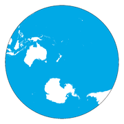
The Water Hemisphere only has about one-eighth of the world's land,[1] including Easter Island, Hawaii, the Pacific Islands, Maritime Southeast Asia, the southern portion of the Malay Peninsula, the southern tip of the Indochinese Peninsula, Taiwan, the Ryukyu Islands, and the Southern Cone of the Americas. Antarctica, Australia and Zealandia are solely within the Water Hemisphere. Some sources[1] further divide land into "dry land" and "ice cap". Antarctica provides the Water Hemisphere with the majority of Earth's ice.
Most of the Pacific Ocean and the Indian Ocean, and the whole Southern Ocean, are in the Water Hemisphere. Proportionately, the Water Hemisphere is approximately 89% water (almost all pertaining to the World Ocean), 6% dry land and 5% polar ice cap.[1]
The table below follows the assignments of Alphonse Berget of land to the two hemispheres.[2]
Continent Area in the Land Hemisphere (km2) Area in the Water Hemisphere (km2) Africa 29,818,400 0 Americas 34,955,670 3,391,010 Antarctica 0 13,120,000 Asia 40,897,241 3,245,649 Australia and the Pacific Islands 0 8,958,630 Europe 9,732,250 0 Land area within the hemisphere 115,403,561 (80.1%) 28,715,289 (19.9%)
See also
- Dumet Island (in French)
- Geographical centre of Earth
References
- Boggs, Samuel Whittemore (December 1945). "This Hemisphere". Journal of Geography. 44 (9): 345–355. doi:10.1080/00221344508986498.
- Berget, Alphonse (1913). "Répartition géographique des Océans (détermination du pôle continental)". 10 (in French). V. Annales de l'Institut océanographique. Cite journal requires
|journal=(help) - "L'ILE DUMET: LE NOMBRIL DU MONDE". France Secret (in French). Archived from the original on 10 November 2013.
- "How Much of Humanity is on Your Side of World?". Brilliant Maps. 27 September 2015. Retrieved 12 December 2016.