Gulf Islands
The Gulf Islands are the islands in the Strait of Georgia (also known as the Salish Sea or the Gulf of Georgia), between Vancouver Island and the mainland of British Columbia, Canada.
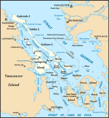
According to BC Geographical Names (BCGNIS) the name "Gulf Islands" was originally intended and commonly understood to refer to the archipelago at the southern end of the Strait of Georgia—from Gabriola Island in the north to Saturna Island in the southeast and D'Arcy Island in the southwest. During the 1990s, however, the name began to be applied to all the islands in the Strait of Georgia, resulting in the introduction of the term "Southern Gulf Islands", which BCGNIS calls a misnomer, to distinguish the original "Gulf Islands" from the rest, which are sometimes called the "Northern Gulf Islands". BCGNIS further notes that Quadra Island is increasingly described as the "northernmost of the Gulf Islands".[1]
The division of the Gulf Islands into two groups, the Southern and Northern Gulf Islands, is relatively common. The dividing line is approximately that formed by the city of Nanaimo on Vancouver Island, and the mouth of the Fraser River on the mainland. The larger populated islands are served by BC Ferries, which operates various vehicle and passenger ferries between the Gulf Islands and to terminals near the major cities of Nanaimo and Victoria on Vancouver Island as well as Vancouver on the mainland. BC Ferries distinguishes between the Southern Gulf Islands and the Northern Gulf Islands.[2] Their Northern Gulf Islands includes both Quadra Island and Cortes Island, as well as some islands far to the north, such as Malcolm Island and Cormorant Island.[3] Natural Resources Canada maps the Gulf Islands as including the "Southern Gulf Islands", the islands of Howe Sound (such as Bowen Island, Gambier Island, and Keats Island), along with Lasqueti Island, Hornby Island, and Denman Island.[4]
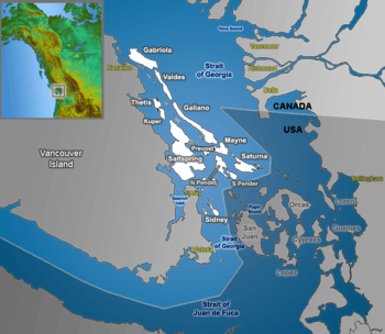
Southern Gulf Islands


The Southern Gulf Islands include hundreds of islands and islets, and form part of a larger archipelago that also includes the nearby San Juan Islands of the state of Washington, in the United States.
The Southern Gulf Islands are perhaps best known for their artists, wineries, Mediterranean-climatic conditions[5][6][7], fromageries, and farms, as well as for their natural beauty. Boating, kayaking, hiking, camping and wildlife viewing are all possible in the Southern Gulf Islands.
The major Southern Gulf Islands are as follows:
Capital Regional District
- Galiano Island
- Mayne Island
- North and South Pender Islands
- Salt Spring Island
- Saturna Island
Cowichan Valley Regional District
- Penelakut Island (Formerly Kuper Island)
- Thetis Island
- Valdes Island
Sunshine Coast Regional District
- Gambier Island
- Keats Island
- Nelson Island
- Pasley Islands
- Thormanby Islands
Squamish Regional District
Northern Gulf Islands
The major Northern Gulf Islands are as follows:
Powell River Regional District
Quadra Island is sometimes said to be part of the Gulf Islands.[1] It is more often designated as part of the Discovery Islands.
Geography
This table provides an overview of the major Southern Gulf Islands:
| Island | Population | Area (km2) | Area (mi2) | Density (per km2) |
|---|---|---|---|---|
| Gabriola | 4,000 | 57.6 | 22.2 | 69.4 |
| Galiano | 1,044 | 60.15 | 23.22 | 17.4 |
| Penelakut | 302 | |||
| Mayne | 1,071 | 21 | 8 | 51 |
| Pender | 2,245 | 34 | 13 | 66.0 |
| Salt Spring | 10,557 | 182.7 | 70.5 | 57.8 |
| Saturna | 350 | 31 | 12 | 11.3 |
| Thetis | 350 | |||
| Valdes | few | 23 | 9 |
"Gulf of Georgia"
The name "Gulf Islands" comes from "Gulf of Georgia," the original term used by George Vancouver in his mapping of the southern part of the archipelago and which before the San Juan Island dispute also was taken to include what have since been called the San Juan Islands. Strictly speaking, the Strait of Georgia is only the wide, open waters of the main strait between the mainland and Vancouver Island, and does not officially refer to the adjoining waters between the islands and Vancouver Island but has become a common misnomer for the entire Gulf, which includes waters such as Active Pass (between Galiano Island and Mayne Island), Trincomali Channel (between Galiano Island and Saltspring Island), Sansum Narrows (between Saltspring Island and Vancouver Island), and Malaspina Strait (between Texada Island and the mainland around Powell River). "The Gulf" refers to all such waters collectively, and to those communities and shores surrounding it.[8] Only the term "Strait of Georgia" remains in the provincial gazette although its use as a synonym for the Gulf is unofficial, while the term Gulf of Georgia remains in current use though not in the provincial gazette.
The term Salish Sea was adopted in 2010 to refer to the Strait of Georgia, the Strait of Juan de Fuca, Puget Sound, and all connecting and adjoining waters.[9]
Ecology
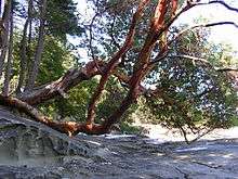
The islands and surrounding ocean are rich with ecologically diverse plants and sea life including Garry oaks, wild lilies, kelp beds and Orcas. Gulf Islands National Park Reserve of Canada was established in 2003 by Parks Canada to protect the area’s unique ecosystem.
The Gulf Islands are home to one of the last remaining pockets of Garry oak ecosystems. Only about five percent of Garry oak ecosystems remain in their natural state, landing 91 of the approximately 350 species it supports on the province's list of species at risk. The unique Mediterranean characteristics of the islands' climate supports the Garry oak ecosystem. Garry oak ecosystems are home to more plant species, such as the camas, than any other terrestrial ecosystem in coastal B.C. and are one of Canada's most at-risk natural habitats.
Today, Garry oak meadows exist in the shallow and exposed soil of valleys, rocky foothills and southern slopes—areas that the settlers of the past 150 years have found unsuitable for agriculture or development.
The Garry Oak Ecosystems Recovery Team (GOERT), a partnership of a number of governmental and non-governmental agencies that comprise 22 individuals, was established in 1999 after the delegates of the First International Garry Oak Ecosystem Symposium met in Victoria and declared the ecosystem endangered. Since then, GOERT has been working to motivate public and private restoration of the rare ecosystem and promote conservation activities.
Agriculture
| Salt Spring Island | ||||||||||||||||||||||||||||||||||||||||||||||||||||||||||||
|---|---|---|---|---|---|---|---|---|---|---|---|---|---|---|---|---|---|---|---|---|---|---|---|---|---|---|---|---|---|---|---|---|---|---|---|---|---|---|---|---|---|---|---|---|---|---|---|---|---|---|---|---|---|---|---|---|---|---|---|---|
| Climate chart (explanation) | ||||||||||||||||||||||||||||||||||||||||||||||||||||||||||||
| ||||||||||||||||||||||||||||||||||||||||||||||||||||||||||||
| ||||||||||||||||||||||||||||||||||||||||||||||||||||||||||||
In most parts of Canada, olive trees cannot thrive; the long, harsh winter and short, humid summer and spring make it difficult for olives to grow comfortably and properly, but Pender Island, Saturna Island, and Salt Spring Island have a Mediterranean style climate that permits olive production.[11][12]

Banana Joe Clemente was one of the first Islanders to introduce olive trees to the Southern Gulf Islands in 1993 growing dozens from seed. In 1994 / 1995 planting a grove of the seed-grown olive trees around a Botchi pit on Salt Spring Island. He also distributed them to Islanders for their private gardens. Banana Joe is also responsible for introducing Musa basjoo, a hardy species of Banana plant to Salt Spring Island.
Farm owner Andrew Butt planted his first olive tree in 2001 at his farm on Pender Island, using Frantoio and Leccino cultivars that he obtained from California.[12] He uses kelp obtained from the surrounding straits as fertilizer and uses a pruning method that enhances the sunlight exposure on the trees.[12] Michael Pierce and colleagues established an olive tree nursery on Saturna Island in 2009 that supplied olive trees to the region.[13]
Provincial Parks and Protected Areas
- Bellhouse Provincial Park, Galiano Island
- Bodega Ridge Provincial Park, Galiano Island
- Burgoyne Bay Provincial Park, Saltspring Island
- Collinson Point Provincial Park, Galiano Island
- Dionisio Point Provincial Park, Galiano Island
- Drumbeg Provincial Park, Gabriola Island
- Jedediah Island Marine Provincial Park
- Montague Harbour Marine Provincial Park, Galiano Island
- Wakes Cove Provincial Park Valdes Island
See also
- List of islands of Canada
- List of National Parks of Canada
- Southern Gulf Islands Electoral Area
References
- "Gulf Islands". BC Geographical Names. Retrieved 2011-07-30.
- "Southern Gulf Islands Schedules". BC Ferries. Retrieved 31 July 2011.
- "Northern Gulf Islands Schedules". BC Ferries. Retrieved 31 July 2011.
- "Waterscape Gulf Islands". Natural Resources Canada. Archived from the original on 27 September 2011. Retrieved 31 July 2011.
- "Top 10 Hidden Gem Destinations Across Canada That You Need To Discover, According To Parks Canada". www.mtlblog.com. February 20, 2019.
- Schwartz, Alyssa; Schwartz, Alyssa (September 23, 2019). "This New Cruise Lets Guests Soak Up Canada's Most Remote—and Noteworthy—Wine Region".
- "Southern Gulf Islands offer Mediterranean-style getaways to Metro Vancouver residents". The Georgia Straight. May 17, 2017.
- "About the Strait • Georgia Strait Alliance".
- "Salish Sea". BC Geographical Names. Retrieved 2011-07-30.
- Environment Canada — Canadian Climate Normals 1981-2010, accessed 11 September 2017
- Mccarthy, Michael (2016-09-06). "Bananas and olives now thriving in the Banana Belt of Canada". The Province.
- Adams, Barbara (2015-03-26). "Canadian Farmer Succeeds with Olives and Gives Kelp Seaweed Some of the Credit". Olive Oil Times.
- "At the farmgate – Saturna Olive Consortium". The Province. 2014-01-25.
External links
| Wikimedia Commons has media related to Gulf Islands. |

- Gulf Islands National Park Reserve — Parks Canada
- Come to the Islands Canadian Geographic Special Feature on B.C.'s Gulf Islands
- Southern Gulf Islands Atlas
- Islands Trust
| Subdivisions |  | |
|---|---|---|
| Communities | ||
| Metro areas and agglomerations |
| |
| Regions | ||
| ||