Cypress Hills (Canada)
The Cypress Hills are a geographical region of hills in southwestern Saskatchewan and southeastern Alberta, Canada.
| Cypress Hills | |
|---|---|
 The Cypress Hills | |
| Highest point | |
| Elevation | 1,468 m (4,816 ft) |
| Coordinates | 49°37′48″N 110°21′34″W |
| Geography | |
 Cypress Hills Cypress Hills location in Western Canada | |
| Country | Canada |
| Provinces | Alberta and Saskatchewan |
The highest point in the Cypress Hills is at Head of the Mountain in Alberta at 1,466 metres (4,810 ft). The highest point in Saskatchewan is 1,392 m (4,567 ft), in a farmer's field in the Cypress Hills, at 49°33′N 109°59′W.[1][2]
Name
The Cypress Hills have been known by a wide number of native and European names throughout their history. An 1882 Blackfoot–English dictionary written by C. M. Lanning provided the Blackfoot name I-kim-e-kooy, which translates as "striped earth" or "earth over earth". The Cree name, in use at the same time, was Manâtakâw, (spelled in a variety of anglicized forms including "Mun-a-tuh-gow"), sometimes said to mean "beautiful upland" but more accurately referring to "an area to be respected, protected, taken care of and/or taken care with". The Assiniboine name is wazíȟe.[3] The Gros Ventre name is θáaciih "pine trees".[4] Early Métis hunters, who spoke a variation of French, called the hills les montagnes des Cyprès, in reference to the abundance of jack pine trees. In the Canadian French spoken by the Métis, the jack pine is called cyprès,[5] although it is not a true cypress tree. The English translation is Cypress Hills.[6]
Geology
The hills are not true mountains but are rather the remnants of erosion of a Tertiary plateau of sediment formed during the initial uplift of the Rocky Mountains. This uplift caused the local portion of the Great Plains – above which the hills now rise – to be elevated, with the result that rivers flowing to the north and south then eroded most of the softer sediments onto the lower part of the plains. Today, the Cypress Hills form a major drainage divide separating rivers draining to the Gulf of Mexico (via the Missouri River) from those draining to Hudson Bay and James Bay via the Nelson River; thus the Cypress Hills form a water divide. There is a ranch northwest of Eastend, Saskatchewan, called Dividing Springs Ranch; the water from this spring goes both south to Gulf of Mexico and north to Hudson Bay.[7]
The Cypress Hills are among the northernmost points that remained above the southwestern margin of the Laurentide Ice Sheet during the most recent glacial period, the Wisconsin glaciation. The Cypress Hills are surrounded by a series of morainal ridges composed of glacial till deposited when a glacier paused during its retreat 15,000 years ago.[8]
Ecology

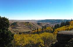
The hills, because of the higher precipitation they receive, support extensive forest and also some rare fescue grassland. Most of the flora is shared with the mountains in states such as Montana and Wyoming rather than with the rest of Canada. The altitude of the hills, which is similar to the altitude of Banff also shares some similar flora and fauna with the Alberta mountain parks. Southern facing slopes tend to support prairie, northern slopes are covered with forest.
The hills currently host cougars. Cattle graze throughout the Cypress Hills Provincial Park, especially on the prairie on the flat tops of the Hills, though stream bank damage in the spruce/lodgepole pine/aspen forest indicates their presence everywhere in the Hills.
History
Historically the Cypress Hills were a meeting and conflict area for various Native Americans and Aboriginal Canadians (First Nations) including the Cree, Assiniboine, Atsina, Blackfoot, Saulteaux, Sioux, Crow, and others. During the 19th century Métis settled in the hills, hunting and often wintering there. The Cypress Hills Massacre, a key event in Canadian history leading to the creation of the North-West Mounted Police, occurred in the hills when a group of American wolfers from Montana massacred an Assiniboine encampment. Fort Walsh was established to bring law and order to the Canada–US border region.
Interprovincial park
The Cypress Hills Provincial Park in Saskatchewan was established in 1931, and it was extended into Alberta in 1951, and Cypress Hills Interprovincial Park was created in 1989 which joined the parks on either side of the provincial border and also includes Fort Walsh National Historic Site. Cypress Hills Interprovincial Park.[9]
The Saskatchewan side of the park is divided into two blocks, Centre Block which has fully developed yearround tourist facilities and West Block Wilderness area with rustic camping and also where Fort Walsh is also located. The Centre Block is located 30 kilometres south of Maple Creek on Highway 21. The West Block is located 45 kilometres southwest of Maple Creek on Highway 271.
The Alberta portion of the Cypress Hills contains the tourist destination of Elkwater, a community with campground facilities located on the southern shore of Elkwater Lake. The townsite is mainly made up of summer cabins. Elkwater is located about 70 kilometres southeast of Medicine Hat.
Climate
Cypress Hills has a subarctic climate (Dfc) due to its elevation above the surrounding area. Summer days are mild to warm coupled with cool nights, while winters are cold and snowy with annual snowfall averaging 100 inches (255 cm). Precipitation peaks during the month of June, where thunderstorms are common. Chinook winds can raise the temperature 9°F (5°C) in an hour, with it not being uncommon for the temperature to go from 14°F (-10°C) to 68°F (20°C) in a 12 hour period.[10] The highest single day snowfall is 23.6 inches (60 cm) and occurred on May 15th, 1999. The highest snow depth recorded is 31.5 inches (80 cm) and occurred on February 28th, 1994. The highest temperature recorded is 104.9°F (40.5°C) and occurred on May 29th, 1988. The lowest temperature recorded is -44.5°F (-42.5°C) and occurred on January 13th, 2005.[11]
| Climate data for Cypress Hills | |||||||||||||
|---|---|---|---|---|---|---|---|---|---|---|---|---|---|
| Month | Jan | Feb | Mar | Apr | May | Jun | Jul | Aug | Sep | Oct | Nov | Dec | Year |
| Record high °C (°F) | 19.0 (66.2) |
18.0 (64.4) |
19.0 (66.2) |
26.0 (78.8) |
40.5 (104.9) |
34.0 (93.2) |
34.5 (94.1) |
34.5 (94.1) |
32.0 (89.6) |
28.0 (82.4) |
21.0 (69.8) |
15.0 (59.0) |
40.5 (104.9) |
| Average high °C (°F) | −3.0 (26.6) |
−1.4 (29.5) |
2.4 (36.3) |
9.8 (49.6) |
15.2 (59.4) |
19.1 (66.4) |
23.2 (73.8) |
22.8 (73.0) |
16.6 (61.9) |
10.1 (50.2) |
1.7 (35.1) |
−2.3 (27.9) |
9.5 (49.1) |
| Daily mean °C (°F) | −9 (16) |
−7.2 (19.0) |
−2.9 (26.8) |
3.5 (38.3) |
8.7 (47.7) |
12.7 (54.9) |
15.9 (60.6) |
15.3 (59.5) |
9.6 (49.3) |
4.0 (39.2) |
−3.5 (25.7) |
−8.0 (17.6) |
3.3 (37.9) |
| Average low °C (°F) | −15.0 (5.0) |
−13.0 (8.6) |
−8.2 (17.2) |
−2.9 (26.8) |
2.1 (35.8) |
6.3 (43.3) |
8.6 (47.5) |
7.6 (45.7) |
2.7 (36.9) |
−2.2 (28.0) |
−8.6 (16.5) |
−13.7 (7.3) |
−3.0 (26.6) |
| Record low °C (°F) | −42.5 (−44.5) |
−40.0 (−40.0) |
−35.5 (−31.9) |
−26.5 (−15.7) |
−11.5 (11.3) |
−3.5 (25.7) |
0.0 (32.0) |
−4.0 (24.8) |
−10.0 (14.0) |
−28.5 (−19.3) |
−39.0 (−38.2) |
−41.5 (−42.7) |
−42.5 (−44.5) |
| Average precipitation mm (inches) | 33.3 (1.31) |
31.0 (1.22) |
43.3 (1.70) |
41.4 (1.63) |
74.0 (2.91) |
103.3 (4.07) |
59.7 (2.35) |
47.8 (1.88) |
58.9 (2.32) |
36.8 (1.45) |
32.8 (1.29) |
38.3 (1.51) |
600.6 (23.64) |
| Source: Environment Canada[12] | |||||||||||||
See also
References
- "Table 15.3 Selected principal heights, by province and territory". Statistics Canada. Retrieved 10 May 2014.
- Kerslake, Danny (5 July 2017). "Mystery of Sask.'s nameless highest point solved by podcast". CBC News. Retrieved 5 March 2018.
- "AISRI Dictionary Database Search--prototype version. Assiniboine". American Indian Studies Research Institute. Retrieved 7 July 2012.
- Cowell, A.; Taylor, A.; Brockie, T. "Gros Ventre ethnogeography and place names: A diachronic perspective". Anthropological Linguistics. 58 (2): 132–170. doi:10.1353/anl.2016.0025.
- forêts, Gouvernement du Canada, Ressources naturelles Canada, Service canadien des. "Pin gris". aimfc.rncan.gc.ca.
- Johnston, Alex (1987). Plants and the Blackfoot. Lethbridge: Lethbridge Historical Society. p. 6. ISBN 978-0919224728.
- "Eastend Auto Tour #3" (PDF). Town of Eastend, Saskatchewan. Retrieved 6 January 2020.
- Gray, Charlotte (2004). The Museum Called Canada: 25 Rooms of Wonder. Random House. ISBN 978-0-679-31220-8.
- "Cypress Hills Interprovincial Park" (PDF). Government of Saskatchewan. Archived from the original (PDF) on 13 March 2006.
- "Cypress Hills Info". www.cypresshills.com. Retrieved 8 June 2020.
- Canada, Environment and Climate Change (25 September 2013). "Canadian Climate Normals 1981-2010 Station Data - Climate - Environment and Climate Change Canada". climate.weather.gc.ca. Retrieved 8 June 2020.
- "Canadian Climate Normals 1981–2010". Retrieved 7 April 2020.
| Physiographic sub-regions |
| ||||||
|---|---|---|---|---|---|---|---|
| Physical features |
| ||||||
| Ecozones | |||||||
| Parks and protected areas |
| ||||||
| Historic regions | |||||||
| Aboriginal peoples |
| ||||||
| |||||||