Alpide belt
The Alpide belt or Alpine-Himalayan orogenic belt[1] is a seismic belt and orogenic belt that includes an array of mountain ranges extending for more than 15,000 km along the southern margin of Eurasia, stretching from Java and Sumatra, through the Indochinese Peninsula, the Himalayas and Transhimalayas, the mountains of Iran, Caucasus, Anatolia, the Mediterranean, and out into the Atlantic.[2] It includes, from west to east, the major ranges of the Atlas Mountains, the Alps, the Caucasus Mountains, Alborz, Hindu Kush, Karakoram, and the majestic Himalayas. It is the second most seismically active region in the world, after the circum-Pacific belt (the Ring of Fire), with 17% of the world's largest earthquakes.[2]
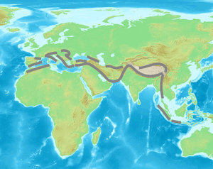
The Alpide belt is being created by ongoing plate tectonics such as the Alpine orogeny. The belt is the result of Mesozoic-to-Cenozoic-to-recent closure of the Tethys Ocean and process of collision between the northward-moving African, Arabian and Indian plates with the Eurasian plate.[1]
Main ranges (from west to east)
- Cantabrian Mountains (incl. the Basque Mountains), Sistema Central, Sistema Ibérico, Pyrenees, Alps, Carpathians, Balkan Mountains (Balkanides), Rila-Rhodope massifs, Thracian Sea islands, Crimean Mountains - entirely in Europe
- Atlas and Rif Mountains in Northern Africa, Baetic System (Sierra Nevada and Balearic Islands), Apennine Mountains, Dinaric Alps, Pindus (Hellenides), and Mount Ida;
- Caucasus Mountains (on the limits between Asia and Europe), Kopet Mountains, Pamir, Alay Mountains, Tian Shan, Altai Mountains, Sayan Mountains;
- Pontic Mountains, Armenian Highland, Alborz, Hindu Kush, Kunlun Mountains, Hengduan Mountains, Annamite Range, Titiwangsa Mountains, Barisan Mountains - entirely in Asia;
- Taurus Mountains, Troodos Mountains, Zagros Mountains, Makran Highland, Sulaiman Mountains, Karakoram, Himalayas, Transhimalaya, Patkai, Chin Hills, Arakan Mountains, Andaman and Nicobar Islands - entirely in Asia.
Indonesia lies between the Pacific Ring of Fire along the northeastern islands adjacent to and including New Guinea and the Alpide belt along the south and west from Sumatra, Java and the Lesser Sunda Islands (Bali, Flores, and Timor). The 2004 Indian Ocean earthquake just off the coast of Sumatra was located within the Alpide belt.
References
- K.M. Storetvedt, K. M., The Tethys Sea and the Alpine-Himalayan orogenic belt; mega-elements in a new global tectonic system, Physics of the Earth and Planetary Interiors, Volume 62, Issues 1–2, 1990, Pages 141–184 Abstract
- "Where do earthquakes occur?". USGS. Archived from the original on 5 August 2014. Retrieved 8 March 2015.
- Historic Earthquakes & Earthquake Statistics – USGS
- "Ring of Fire", Plate Tectonics, Sea-Floor Spreading, Subduction Zones, "Hot Spots" – USGS