Windward Islands
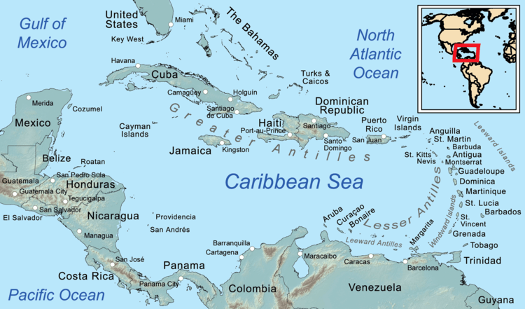
The Windward Islands, also known as the Islands of Barlovento, are the southern, generally larger islands of the Lesser Antilles, within the West Indies. They lie south of the Leeward Islands, approximately between latitudes 10° and 16° N and longitudes 60° and 62° W. The name was also used to refer to a British colony in these islands, existing between 1833 and 1960 and consisting of the islands of Saint Lucia, Saint Vincent, the Grenadines, and Grenada. The island of Dominica was traditionally a part of the Leeward Islands until 1940, when it was transferred from the Leeward Islands colony to the Windward Islands.)
| English: Windward Islands French: Îles du Vent | |
|---|---|
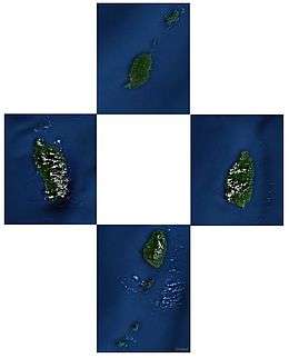 Political Windward Islands. Clockwise: Grenada, Saint Lucia, Saint Vincent and the Grenadines, Dominica. | |
| Geography | |
| Location | Caribbean Sea and Atlantic Ocean |
| Coordinates | 14°N 61°W |
| Total islands | 90+ |
| Major islands | Dominica Saint Lucia Saint Vincent Grenada |
| Area | 3,232.5 km2 (1,248.1 sq mi) |
| Highest elevation | 1,447 m (4,747 ft) |
| Highest point | Morne Diablotins, Dominica |
| Administration | |
| Largest settlement | Roseau |
| Largest settlement | Castries |
| Largest settlement | Kingstown |
| Largest settlement | St. George's |
| Demographics | |
| Population | c. 854,000 |
| Pop. density | 227/km2 (588/sq mi) |
Name and geography
The Windward Islands are called such because they were more windward to sailing ships arriving to the New World than the Leeward Islands, given that the prevailing trade winds in the West Indies blow east to west. The trans-Atlantic currents and winds that provided the fastest route across the ocean brought these ships to the rough dividing line between the Windward and Leeward islands.
Vessels in the Atlantic slave trade departing from the British Gold Coast and Gulf of Guinea in Africa would first encounter the southeasternmost "Windward" islands of the Lesser Antilles in their west-northwesterly heading to final destinations in the Caribbean and North and Central America. The chain of Windward Islands forms a part of the easternmost boundary of the Caribbean Sea.[1][2]
List of the Windward Islands
The Windward Islands are as follows:[1][3][4]
See also
- Leeward Islands
- Southern Caribbean
- Lesser Antilles topics
- Windward Islands topics
- Leeward Islands topics
- Windward Islands cricket team
References
- "Windward Islands". Encyclopædia Britannica.
[A] line of West Indian islands constituting the southern arc of the Lesser Antilles, at the eastern end of the Caribbean Sea, between latitudes 12° and 16° N and longitudes 60° and 62° W. They include, from north to south, the English-speaking islands of Saint Lucia, Saint Vincent, and Grenada; and, between Saint Vincent and Grenada, the chain of 32 islands known as the Grenadines. Though near the general area, Trinidad and Tobago (at the south end of the group) and Barbados (just east) are usually not considered part of the Windward Islands.
- Chapter 4 - The Windward Islands and Barbados - U.S. Library of Congress
- "Windward Islands". Footprint Travel Guides. Retrieved 23 March 2013.
- "Windward Islands". Encyclopædia Britannica, Inc. Retrieved 7 July 2018.
External links
- Chisholm, Hugh, ed. (1911). . Encyclopædia Britannica. 26 (11th ed.). Cambridge University Press. p. 716.