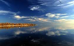
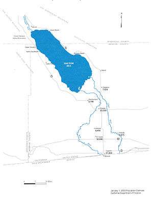
Salton Sea
The Salton Sea is a shallow, saline, endorheic rift lake located directly on the San Andreas Fault, predominantly in the U.S. state of California's Imperial and Coachella valleys.
| Salton Sea | |
|---|---|
 | |
| Location | Colorado Desert Imperial and Riverside Counties, California, U.S. |
| Coordinates | 33°18′47″N 115°50′04″W |
| Type | Endorheic rift lake |
| Primary inflows | Alamo River New River Whitewater River |
| Primary outflows | None |
| Catchment area | 8,360 square miles (21,700 km2) |
| Basin countries | United States, Mexico |
| Surface area | 343 sq mi (889 km2) |
| Max. depth | 43 ft (13 m) |
| Water volume | 6,000,000 acre⋅ft (7.4 km3) |
| Surface elevation | −236 ft (−71.9 m) (below sea level) |
| Settlements | Bombay Beach, Desert Beach, Desert Shores, Salton City, Salton Sea Beach, North Shore |
| References | U.S. Geological Survey Geographic Names Information System: Salton Sea |
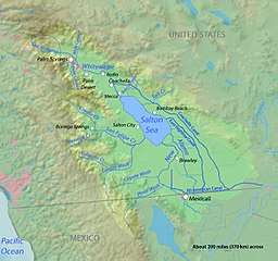
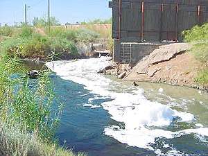
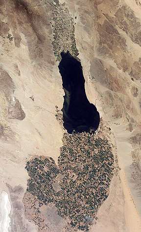
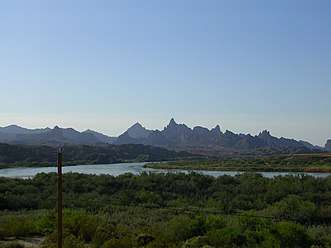
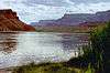
The lake occupies the lowest elevations of the Salton Sink in the Colorado Desert of Imperial and Riverside counties in Southern California. Its surface is 236.0 ft (71.9 m) below sea level as of January 2018.[1] The deepest point of the sea is 5 ft (1.5 m) higher than the lowest point of Death Valley. The sea is fed by the New, Whitewater, and Alamo rivers, as well as agricultural runoff, drainage systems, and creeks.
Over millions of years, the Colorado River has flowed into the Imperial Valley and deposited soil (creating fertile farmland), building up the terrain and constantly changing the course of the river. For thousands of years, the river has alternately flowed into and out of the valley, alternately creating a freshwater lake, an increasingly saline lake, and a dry desert basin, depending on river flows and the balance between inflow and evaporative loss. The cycle of filling has been about every 400–500 years and has repeated many times.
Around 700 AD, a major shift in the river's course caused a flow of water into the basin, creating Lake Cahuilla, which at its peak was 115 miles (185 km) long, as much as 35 miles (56 km) wide, and 314 feet (96 m) deep, making it one of the largest lakes in North America. The sudden existence of a lake in the arid Salton basin, during a time of an extended severe drought, was serendipitous for the hunter-gatherers who lived there: although the water was too saline to drink, its presence attracted fish and waterfowl to the area.[2] The lake existed for over 600 years, until silt blocked the entry channel, creating a closed basin that dried up in around 50 years.
The latest natural cycle occurred around 1600–1700 AD, according to Native Americans who spoke with the first European settlers. Fish traps still exist at many locations, and the Native Americans evidently moved the traps depending upon the cycle.
The inflow of water from the now heavily controlled Colorado River was accidentally created by the engineers of the California Development Company in 1905. In an effort to provide water into the Imperial Valley for farming, beginning in 1900, an irrigation canal was dug from the Colorado River to the old Alamo River channel, directing the water west and then north near Mexicali. The headgates and canals suffered silt buildup, so a series of cuts were made in the bank of the Colorado River to further increase the water flow. The resulting outflow overwhelmed the third intake, "Mexican Cut", near Yuma, Arizona, and the river flowed into the Salton Basin for two years, filling what was then a dry lake bed and creating the modern sea, before repairs were completed.[3][4][5]
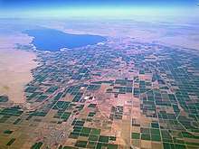
While it varies in dimensions and area with fluctuations in agricultural runoff and rainfall, the Salton Sea is about 15 by 35 miles (24 by 56 km). With an estimated surface area of 343 square miles (890 km2) or 350 square miles (910 km2), the Salton Sea is the largest lake in California by surface area.[6][7][8] The average annual inflow is less than 1.2 million acre⋅ft (1.5 km3), which is enough to maintain a maximum depth of 43 feet (13 m) and a total volume of about 6 million acre⋅ft (7.4 km3). However, due to changes in water apportionments agreed upon for the Colorado River under the Quantification Settlement Agreement of 2003, the surface area of the sea is expected to decrease by 60% between 2013 and 2021.[9][10]
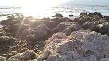
The lake's salinity, about 56 grams per litre (7.5 oz/US gal), is greater than that of the Pacific Ocean (35 g/l (4.7 oz/US gal)), but less than that of the Great Salt Lake (which ranges from 50 to 270 g/l (6.7 to 36.1 oz/US gal)). The concentration has been increasing at a rate of about 3% per year.[11] About 4 million short tons (3.6 million t) of salt are deposited in the valley each year.[12]
History
The area was once part of a vast inland sea that covered a large area of Southern California. Geologists estimate that for three million years, at least through all the years of the Pleistocene glacial age, a large delta was deposited by the Colorado River in the southern region of the Imperial Valley. Eventually, the delta reached the western shore of the Gulf of California, creating a barrier that separated the area of the Salton Sea from the northern reaches of the Gulf. Were it not for this barrier, the entire Salton Sink along with the Imperial Valley would be submerged as the Gulf would extend as far north as Indio.[13]
Since the exclusion of the ocean, the Salton Basin has over the ages been alternately a freshwater lake, an increasingly saline endorheic lake, and a dry desert basin, depending on river flows and the balance between inflow and evaporative loss. A lake exists only during times it is replenished by the rivers and rainfall, a cycle that has repeated many times over hundreds of thousands of years,[14] perhaps cycling every 400 to 500 years.[15]
Evidence that the basin was occupied periodically by multiple lakes includes wave-cut shorelines at various elevations preserved on the hillsides of the east and west margins of the present lake, the Salton Sea. These indicate that the basin was occupied intermittently as recently as a few hundred years ago. The last of the Pleistocene lakes to occupy the basin was Lake Cahuilla, also periodically identified on older maps as Lake LeConte or the Blake Sea, after American professor and geologist William Phipps Blake.
Throughout the Spanish period of California's history, the area was referred to as the "Colorado Desert" after the Colorado River. In a railroad survey completed in 1855, it was called "the Valley of the Ancient Lake". On several old maps from the Library of Congress, it has been found labeled "Cahuilla Valley" (after the local Native American tribe) and "Cabazon Valley" (after a local Native American chief – Chief Cabazon). "Salt Creek" first appeared on a map in 1867 and "Salton Station" is on a railroad map from 1900, although this place had been there as a rail stop since the late 1870s.[16] Until the advent of the modern sea, the Salton Sink was the site of a major salt-mining operation.[17]
History during the 1900s
In 1900, the California Development Company began construction of irrigation canals to divert water from the Colorado River into the Salton Sink, a dry lake bed. After construction of these irrigation canals, the Salton Sink became fertile for a time, allowing farmers to plant crops.[18]
Within two years, the Imperial Canal became filled with silt from the Colorado River. Engineers tried to alleviate the blockages to no avail. In 1905, heavy rainfall and snowmelt caused the Colorado River to swell, overrunning the third intake cut into the bank of the river and sending the flood into the Alamo Canal. The resulting flood poured down the canal, and down two former dry arroyos: the New River in the west, and the Alamo River in the east, each about 60 mi (97 km) long.[19] Over about two years, these two newly created rivers [20] carried the entire volume of the Colorado River into the Salton Sink.[15]
The Southern Pacific Railroad tried to stop the flooding by dumping earth into the canal's headgates area, but the effort was not fast enough, and the river eroded deeper and deeper into the dry desert sand of the Imperial Valley. A large waterfall formed as a result and began cutting rapidly upstream along the path of the Alamo Canal that now was occupied by the Colorado. This waterfall was initially 15 feet (4.6 m) high, but grew to 80 feet (24 m) high before the flow through the breach was stopped. Originally, it was feared that the waterfall would recede upstream to the true main path of the Colorado, becoming up to 100 to 300 feet (30 to 91 m) high, at which point it would be practically impossible to fix the problem.

As the basin filled, the town of Salton, a Southern Pacific Railroad siding, and Torres-Martinez Native American land were submerged. The sudden influx of water and the lack of any drainage from the basin resulted in the formation of the Salton Sea.[21][22]
The U.S. Navy conducted a preliminary inspection of the Salton Sea in January 1940, and the Salton Sea Test Base (SSTB, run by Sandia Labs) was initially commissioned as the Salton Sea Naval Auxiliary Air Station, in October 1942. The SSTB, just to the southeast of Salton City, originally functioned as an operational and training base for seaplanes. Additional activities at the base included experimental testing of solid-fuel plane-launched rockets, jet-assist take-off testing, aeroballistic testing of inert atomic weapon test units at land and marine target areas, training bombing at marine targets, testing of the effects of long-term storage on atomic weapons, testing of the Project Mercury space capsule parachute landing systems, parachute training and testing, and military training exercises. The base was abandoned in 1978.[23]
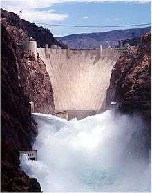
The continuing intermittent flooding of the Imperial Valley from the Colorado River led to the idea of the need for a desilting dam on the Colorado River for flood control. The Imperial Dam was built to avoid the flooding that created the Salton Sea.[24]
Subsequent evolution
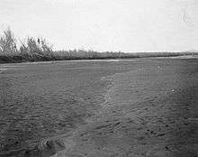
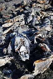
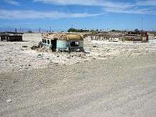
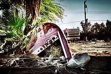
The Salton Sea had some success as a resort area, with Salton City, Salton Sea Beach, and Desert Shores, on the western shore and Desert Beach, North Shore, and Bombay Beach, built on the eastern shore in the 1950s. However, many of the settlements substantially shrank in size, or have been abandoned, mostly due to the increasing salinity and pollution of the lake over the years from agricultural runoff and other sources. Many of the species of fish that lived in the sea have been killed off by the combination of pollutants, salt levels, and algal blooms. Dead fish have been known to wash up in mass quantities on the beaches. The smell of the lake, combined with the stench of the decaying fish, also contributed to the decline of the tourist industry around the Salton Sea. The US Geological Survey describes the smell as "objectionable", "noxious", "unique", and "pervasive".[25]
Some people now visit the Salton Sea and the surrounding settlements to explore the abandoned structures and see the squatter settlement of Slab City. The town of Niland is 1.5 miles (2.4 km) southeast of the sea, with a population of 1,006.
Climate
According to the Köppen climate classification system, the Salton Sea has a Hot desert climate (BWh). According to the United States Department of Agriculture, the Plant Hardiness zone is 9b with an average annual extreme minimum temperature of 28.5 °F (−1.9 °C).[26] The temperature of the surface water changes with the seasonally varying air temperature. Winter surface water can reach temperatures as low as 50 °F (10 °C) and summer surface water highs can reach 95 °F (35 °C).[27]
| Climate data for Salton Sea, Imperial County, CA | |||||||||||||
|---|---|---|---|---|---|---|---|---|---|---|---|---|---|
| Month | Jan | Feb | Mar | Apr | May | Jun | Jul | Aug | Sep | Oct | Nov | Dec | Year |
| Average high °F (°C) | 70.9 (21.6) |
74.5 (23.6) |
80.3 (26.8) |
86.8 (30.4) |
95.0 (35.0) |
102.9 (39.4) |
107.2 (41.8) |
106.6 (41.4) |
102.0 (38.9) |
91.5 (33.1) |
79.0 (26.1) |
69.8 (21.0) |
88.9 (31.6) |
| Average low °F (°C) | 41.7 (5.4) |
45.0 (7.2) |
50.1 (10.1) |
55.3 (12.9) |
62.4 (16.9) |
69.2 (20.7) |
76.7 (24.8) |
77.7 (25.4) |
71.3 (21.8) |
59.9 (15.5) |
48.5 (9.2) |
40.9 (4.9) |
58.3 (14.6) |
| Average precipitation inches (mm) | 0.38 (9.7) |
0.43 (11) |
0.40 (10) |
0.06 (1.5) |
0.02 (0.51) |
0.02 (0.51) |
0.09 (2.3) |
0.22 (5.6) |
0.20 (5.1) |
0.21 (5.3) |
0.15 (3.8) |
0.38 (9.7) |
2.56 (65) |
| Average relative humidity (%) | 39.6 | 37.8 | 33.7 | 28.6 | 27.3 | 24.5 | 29.6 | 32.2 | 30.6 | 30.7 | 34.6 | 38.9 | 32.3 |
| Average dew point °F (°C) | 32.0 (0.0) |
33.9 (1.1) |
35.9 (2.2) |
36.9 (2.7) |
42.2 (5.7) |
45.6 (7.6) |
55.8 (13.2) |
58.3 (14.6) |
52.1 (11.2) |
42.7 (5.9) |
35.3 (1.8) |
30.8 (−0.7) |
41.8 (5.4) |
| Source: PRISM Climate Group[28] | |||||||||||||
Ecology
Potential natural vegetation
According to the A. W. Kuchler U.S. Potential natural vegetation Types, the area roughly within 3 miles (4.8 km) of the sandy shoreline of the Salton Sea would have a Saltbush / Greasewood (40) vegetation type and a Great Basin Shrubland (7) vegetation form.[29]
Fish population
Due to the high salinity, very few fish species can tolerate living in the Salton Sea. Introduced tilapia (hybrid Mozambique × Wami) are the main fish that can tolerate the high salinity levels and pollution.[30][31] Other fresh and brackish water fish species live in the rivers and canals that feed the Salton Sea, including redbelly tilapia, threadfin shad, carp, red shiner, channel catfish, white catfish, largemouth bass, mosquitofish, sailfin molly, and the vulnerable desert pupfish.[31][32]
The California Office of Environmental Health Hazard Assessment has developed a safe eating advisory for fish caught in the Salton Sea based on levels of mercury or PCBs found in local species.[33]
Avian population
The Salton Sea has been termed a "crown jewel of avian biodiversity" by Dr. Milt Friend of the Salton Sea Science Office. Over 400 species have been documented at the Salton Sea. The most diverse and probably the most significant populations of bird life in the continental United States are hosted, rivaled only by Big Bend National Park in Texas.[34] It supports 30% of the remaining population of the American white pelican.[35] The Salton Sea is also a major resting stop on the Pacific Flyway. On 18 November 2006, a Ross's gull, a high Arctic bird, was sighted and photographed there.[36]
Increasing salinity
The lack of an outflow means the Salton Sea does not have a natural stabilization system; it is very dynamic. Fluctuations in the water level caused by variations in agricultural runoff, the ancient salt deposits in the lake bed, and the relatively high salinity of the inflow feeding the sea are all causing increasing salinity. The body was initially a freshwater lake, but by the 1960s, its rising salinity had begun to jeopardize some of its species.[37] With a salinity now exceeding 5.0% w/v (saltier than seawater), most species of fish can no longer survive. A freshwater fish notable for its ability to withstand the rising salinity of the Salton Sea, the desert pupfish, can survive salinities ranging from 0.0% to 7.0%.[38] Fertilizer runoffs have resulted in eutrophication, with large algal blooms and elevated bacterial levels.[39] Both the hypersalinity and presence of contaminants in the Salton Sea triggered massive die-offs in the fish and avian populations; Salt water carries less oxygen than fresh water, which was further depleted by algal blooms and by extreme temperatures during the summer period, and the contamination promoted the outbreak and spread of diseases such as avian cholera. In turn, the loss of several species of fish that the avian population depended on for food increased their risk of starvation, exacerbating their decline.
Geology
Earthquakes and tectonic setting

The Salton Sea and surrounding basin sits over the San Andreas Fault, San Jacinto Fault, Imperial Fault Zone, and a "stepover fault" shear zone system. Geologists have determined that previous flooding episodes from the Colorado River have been linked to earthquakes along the San Andreas Fault. Sonar and other instruments were used to map the Salton Sea's underwater faults during the study. During the period when the basin was filled by Lake Cahuilla, a much larger inland sea, earthquakes higher than magnitude 7 occurred roughly every 180 years, the last one occurring within decades of 1700. Computer models suggest the normal faults in the area are most vulnerable to deviatoric stress loading by filling in of water. Currently, a risk still exists for an earthquake of magnitude 7 to 8. Simulations also showed, in the Los Angeles area, shaking and thus damage would be more severe for a San Andreas earthquake that propagated along the fault from the south, rather than from the north. Such an earthquake also raises the risk for soil liquefaction in the Imperial Valley region.[40][41]
The effective drainage divide that separates the Salton Sea from the Gulf of California is about 9 m (30 ft) in elevation and is located near Delta, northeastern Baja California State, Mexico, south-southeast of Mexicali.[42] Past sea level rise may partially be responsible for the salinity of the lake, while potential future changes in sea levels could occur. However, other factors such as hydrothermal vents, diffusion of salt from minerals and sediment, including concentrated brine, and evaporites are another contributor to salinity, as is the recent lowering of lake levels raising the salinity, though sedimentary records show the lake surface elevation reached levels 10–12 m above world sea level in the 1500s.[43]
Volcanism
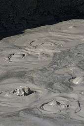
Evidence of geothermal activity is also visible. The Salton Buttes are volcanoes in the geothermal field of the same name. Mudpots and mud volcanoes are found on the eastern side of the Salton Sea.[44] The area is used for geothermal electricity generation, with plants located along the southeastern shore of the Salton Sea in Imperial County.[45]
Remediation efforts
Early efforts and proposals for a sea level canal
Alternatives for "saving" the Salton Sea have been evaluated since 1955.
Interest in the sea was sparked in the 1990s by Congressman Sonny Bono.[46] His widow, Mary Bono Mack, elected to fill his seat, has continued to be interested in the Salton Sea, as has Representative Jerry Lewis of Redlands.[46] In 1998, the Sonny Bono Salton Sea Restoration Project was named for the politician.[46]
In the late 1990s, the Salton Sea Authority, a local joint powers agency, and the US Bureau of Reclamation began efforts to evaluate and develop an alternative to save the Salton Sea. A draft Environmental Impact Report/Environmental Impact Statement, which did not specify a preferred alternative, was released for public review in 2000. Since that time, the Salton Sea Authority has developed a preferred concept[47] that involves the construction of a large dam that would impound water to create a marine sea in the northern and southern parts of the sea and along the western edge.
Many other concepts have been proposed,[48] including piping water from the sea to a wetland in Mexico, Laguna Salada, as a means of salt export, and one by Aqua Genesis Ltd to bring in seawater from the Gulf of California, desalinate it at the sea using available geothermal heat, and sell the water to pay for the plan. This concept would involve the construction of over 20 miles (32 km) of pipes and tunneling, and, with the increasing demand for water at the coastline, would provide an additional 1,000,000 acre feet (1.2 km3) of water to Southern California coastal cities each year.[49]
State restoration plan
In 2003, the Imperial Irrigation District agreed to sell a portion of its allotment from the Colorado River for 45 years to the San Diego County Water Authority.[50] The California State Legislature, by legislation enacted in 2003 and 2004, directed the Secretary of the California Resources Agency to prepare a restoration plan for the Salton Sea ecosystem, and an accompanying Environmental Impact Report.[51] As part of this effort, the Secretary for Resources has established an advisory committee to provide recommendations to assist in the preparation of the Ecosystem Restoration Plan, including consultation throughout all stages of the alternative selection. The California Department of Water Resources and California Department of Fish and Game are leading the effort to develop a preferred alternative for the restoration of the Salton Sea ecosystem and the protection of wildlife dependent on that ecosystem.
On January 24, 2008, the California Legislative Analyst's Office released a report titled "Restoring the Salton Sea."[51] The preferred alternative outlined in the draft plan calls for spending almost $9 billion over 25 years and proposes a smaller but more manageable Salton Sea. The amount of water available for use by humans and wildlife would be reduced by 60% from 365 square miles (950 km2) to about 147 square miles (380 km2). About 52 miles (84 km) of barrier and perimeter dikes – constructed most likely out of boulders, gravel, and stone columns – would be erected, along with earthen berms to corral the water into a horseshoe shape along the northern shoreline of the sea from San Felipe Creek on the west shore to Bombay Beach on the east shore. The central portion of the sea would be allowed to evaporate almost completely and would serve as a brine sink, while the southern portion of the sea would be constructed into a saline habitat complex. Construction on the project would be completed by 2035.
By 2014, large swaths of lake bed were exposed and salt levels drastically increased due to mandated water transfers to metropolitan areas along the coast and other factors, limiting the water inflow. Besides the resulting fish kills, the shrinking lake interrupts the bird migration, causes dust clouds, and negatively impacts local tourism.[52] During the first 15 years after the sale of the Imperial water to San Diego County, the irrigation district has been required to put water into the Salton Sea to compensate for the loss of agricultural runoff needed to replenish the sea. Since the requirement expired in 2017, the district sent a letter to the California State Water Resources Control Board in 2014 asking that the board sponsor negotiations to get the state to fulfill its obligation to stop the deterioration of the sea. Pacific Institute, an Oakland-based environmental think tank, was warning that the lack of replenishment water was leading to a "period of very rapid deterioration."[53] The rapidly shrinking sea was a "looming environmental and public health crisis"[50] With the increased shrinkage, dust storms would increase and a rotten-egg smell could reach to the coastal cities.[53]
In 2018, California's Natural Resources Agency received 11 proposals to increase waterflow to the sea in order to reduce dust and dust-borne toxins. Proposal costs ranged from $300 million to several billion dollars. No winner was selected in this phase.[54] In February 2020, the agency finished the "Bruchard Road Dust Suppression Project" and reported further actions to be taken until 2028.[55]
In popular culture
Films
- A visit to the Salton Sea inspired filmmaker Curtis Harrington to make his dreamlike short film On the Edge (1949),[56] which extensively uses the bubbling mudpots on the edge of the sea.[57] In a 1971 interview, Harrington stated, "The location I used is entirely covered by water now; the sea has risen to cover it."[58]
- As the sea started its decline, independent filmmakers discovered its unique landscape. In the 1990s, a trio of unusual films was shot in the Salton-Sea-area. In 1990 Richard Newton created Small White House,[59] a film exploring a love triangle between JFK, Jackie O., and Marilyn Monroe. In 1991, Nina Menkes made Queen of Diamonds, which explores the life of an alienated Las Vegas blackjack dealer. Queen of Diamonds features a wedding reception held on the beach of the Salton Sea, whose guests includes an Elvis impersonator.[60] The Entire History of the Louisiana Purchase (1998) is an early example of the pseudo-documentary. Joshua Oppenheimer's film includes some striking post-apocalyptic color sequences shot along the banks of the Salton Sea.[61]
- The film, The Salton Sea (2002), is an American crime thriller named after and partially filmed at the Salton Sea.[62]
- The New York Times described the film about some residents of the Bombay Beach, California community on the Salton Sea, Bombay Beach (2010), by Israeli-born filmmaker Alma Har'el, as a "surreal documentary".[63] The film won first prize in the feature documentary section of the Tribeca Film Festival in 2011.[64]
- The short documentary, The Useless Sea (2016), is a cinematic film focusing on the environmental challenges and the beauty surrounding the Salton Sea.[65]
- The documentary, SOS: The Salton Sea Walk (2017)[66] documents efforts to raise awareness of environmental consequences and conservation possibilities for the area.
- The American independent drama, Desert Shores (2019) was filmed at the Salton Sea and based on George McCormick's short story Salton Sea. The film is primarily set in the Desert Shores community, for which the film is named.[67]
Games
- In the video-game Grand Theft Auto V (2013), a location called the Alamo Sea is based on the Salton Sea; Sandy Shores, a town that sits on the lake's southern edge, is based on the town of Desert Shores.[68]
Music
- The video for Michael Jackson's "In the Closet" (1992) was filmed at Salton Sea.[69]
Television
- The History Channel's 2006 episode "Engineering Disasters 18" (#13-04), from the television documentary series Modern Marvels, describes the combined manmade and natural events leading to the creation of the Salton Sea in the early 20th century, its brief popularity as a resort destination midcentury, and its subsequent decline due to high salinity and farm runoff. Impacts to Salton Sea fish and bird populations are addressed and future plans to rescue the sea are described.[70]
- National Geographic Explorer was present on June 10, 2018 to record an encounter between supporters of a flat Earth and members of the Independent Investigations Group. An experiment successfully demonstrated the curvature of the earth via the disappearance over distance of boat-based and shore-based targets.[71]
See also
- Aral Sea
- Lake Urmia
- List of drying lakes
- List of lakes in California
- Dead Sea
References
- "USGS 10254005 Salton Sea NR Westmorland CA". waterdata.usgs.gov.
- Fagan, Brian (2008) The Great Warming: Climate Change and the Rise and Fall of Civilizations New York: Bloomsbury Press. pp.117-118. ISBN 978-1-59691-392-9
- "Salton Sea, History". Archived from the original on 2018-01-02.
- "The Salton Sea, CA". www.desertusa.com. DesertUSA. Retrieved 2019-03-03.
- Cory, Harry Thomas & Blake, William Phipps, The Imperial Valley and the Salton Sink; Trover, Ellen Lloyd, Birth of the Inland Sea: How the Colorado River Created the Salton Sea
- "Restoration of the Salton Sea Final Report December 2007 – Chapter 1. Introduction" (PDF). U.S. Department of the Interior, Bureau of Reclamation, Lower Colorado Region. Retrieved April 3, 2014.
- "LA Times: Drought, drawdowns and death of the Salton Sea".
- Wilson, Janet; James, Ian (March 2, 2019). "Breaking impasse, feds will include Salton Sea in seven-state drought plan, IID says". Desert Sun. Retrieved March 2, 2019.
- San Diego County Water Authority (2014). "Quantification Settlement Agreement". San Diego County Water Authority. Retrieved 2014-10-14.
- THAN, KER (February 18, 2014). "Can California Farmers Save Water and the Dying Salton Sea?". National Geographic News. Retrieved May 20, 2019.
- See https://www.usbr.gov/lc/region/programs/SaltonSea_2004-2014.xlsx, linked at https://www2.usgs.gov/saltonsea/monitoring.html
- Khaled M. Bali (October 5, 2013). "Salton Sea and Salinity". UC Davis, Cooperative Extension Imperial County. Retrieved June 29, 2015.
The salinity of the Pacific Ocean is approximately 35,000 mg/l (1 ppm=1 mg/l). Colorado River water salinity is about 650–700 mg/L. Salton Sea salinity is about 44,000 mg/L, that is approximately 4.4% salt. The amount of salts that is deposited in the Imperial Valley agricultural land with irrigation water is approximately four million tons of salts annually.
- Alles, DL (August 6, 2007). "Geology of the Salton Trough" (PDF). Biology Department. Western Washington University. Retrieved June 6, 2010.
- Singer E. "Ancient Lake Cahuilla – Geology of the Imperial Valley". Archived from the original on June 1, 2009. Retrieved July 10, 2009.
- Pat Laflin (July 29, 2003). "The Salton Sea: California's Overlooked Treasure" (PDF). Coachella Valley Historical Society. pp. 21–26. Archived from the original (PDF) on September 24, 2015. Retrieved February 11, 2015.
- "Carpelan, Lars H. History of the Salton Sea".
- The Salton Sea – Its Beginnings. Accessed 2010-06-14
- "The Salton Sea: California's Overlooked Treasure, Chapter 4".
- Detailed maps, and a film of the breach (and subsequent redamming) are in Plagues & Pleasures on the Salton Sea, a 2006 documentary
- cory & blake, The Imperial Valley and the Salton Sink, a reprint of Irrigation and River Control in the Colorao River Delta, Transaction American Society of Engineers, vol. LXXVI.
- Kennan, G (1917). The Salton Sea: An Account of Harriman's Fight With The Colorado River. New York: The MacMillan Company. Retrieved 2009-07-11.
- Larkin, EL (1907). "A Thousand Men Against A River: The Engineering Victory Over The Colorado River And The Salton Sea". The World's Work: A History of Our Time. XIII: 8606–10. Retrieved July 10, 2009.
- "Salton Sea Test Base Site Inspection Report – sect2-1, 1995".
- Runyon, Luke (March 21, 2019). "How A Dying Lake In California Factors Into The Colorado River's Future". KPBS Public Media. Retrieved May 20, 2019.
- https://www2.usgs.gov/saltonsea/saltonWorkshops/eutrofin.pdf
- "USDA Interactive Plant Hardiness Map". United States Department of Agriculture. Retrieved 2019-07-11.
- "Archived copy" (PDF). Archived from the original (PDF) on 2014-01-04. Retrieved 2014-01-04.CS1 maint: archived copy as title (link)
- "PRISM Climate Group, Oregon State University". www.prism.oregonstate.edu. Retrieved July 10, 2019.
- "U.S. Potential Natural Vegetation, Original Kuchler Types, v2.0 (Spatially Adjusted to Correct Geometric Distortions)". Data Basin. Retrieved 2019-07-11.
- Riedel, R.; B. A. Costa-Pierce (2002). "Review of the Fisheries of the Salton Sea, California, USA: Past, Present, and Future". Reviews in Fisheries Science. 10 (2): 77–112. doi:10.1080/20026491051686.
- Lorenzi, V.; D. Schlenk (2014). "Impacts of combined salinity and temperature extremes on different strains and species of Tilapia inhabiting the watershed of the Salton Sea". North American Journal of Aquaculture. 76 (3): 211–221. doi:10.1080/15222055.2014.893471.
- U.S. Fish & Wildlife Service (2008). "Sonny Bono Salton Sea National Wildlife Refuge: Wildlife List" (PDF). Cite journal requires
|journal=(help) - Admin, OEHHA (December 30, 2014). "Salton Sea". OEHHA. Retrieved June 13, 2018.
- Morrison, Patt (September 17, 2014) "A persuasive case for saving the Salton Sea, California's biggest lake". Los Angeles Times Interview with Tim Krantz
- "ca.audubon.org" (PDF). Archived from the original (PDF) on 2006-01-13.
- "Ross's Gull – 2006". www.southwestbirders.com. Retrieved December 12, 2017.
- Parker, Stephanie (2019-10-09). "How the Salton Sea Became an Eco Wasteland". HowStuffWorks. Retrieved 2019-10-10.
- Dudek and ICF International (2012). Desert Renewable Energy Conservation Plan (DRECP) Baseline Biology Report. (Draft). Prepared for the California Energy Commission.
- NASA page: "Algal bloom in the Salton Sea, California".
- Brothers, Daniel, et al. "Loading of the San Andreas fault by flood-induced rupture of faults beneath the Salton Sea." Nature Geoscience 4.7 (2011): 486–92.
- Ross, JE (July 27, 2011). "Flooding of Ancient Salton Sea Linked to San Andreas Earthquakes". Scripps Institution of Oceanography, University of California at San Diego. Scripps Oceanography News. Retrieved 31 July 2011.
- Tingle, A. "Flood Maps". Firetree.net. Flood. Retrieved 31 July 2011.
- Wardlaw, GD; Valentine DL (January 2005). "Evidence for salt diffusion from sediments contributing to increasing salinity in the Salton Sea, California" (PDF). Hydrobiologia. 533 (1–3): 77–85. doi:10.1007/s10750-004-2395-8. Archived from the original (PDF) on April 16, 2007. Retrieved 31 July 2011.
- Lynch, DK; Hudnut, KW (2008). "The Wister Mud Pot Lineament: Southeastward Extension or Abandoned Strand of the San Andreas Fault?" (PDF). Bulletin of the Seismological Society of America. 98 (4): 1720–29. Bibcode:2008BuSSA..98.1720L. doi:10.1785/0120070252.
- Roth, Sammy (2019-10-14). "Lithium will fuel the clean energy boom. This company may have a breakthrough". Los Angeles Times. Retrieved 2019-10-17.
- CNN article: "Salton Sea rescue to be named for Sonny Bono".
- "phpinfo()". www.saltonsea.ca.gov.
- "US Bureau of Reclamation – Salton Sea Project Office – Salton Sea Brochure – 1999". www.usbr.gov.
- sandiegoreader.com; San Diego Union Times: Ronald Newcomb's Salton Sea proposal
- Perry, Tony (September 3, 2014) "'Salton Sea inaction could cause 'catastrophic change,' report says" Los Angeles Times
- California, State of. "Salton Sea Unit". www.water.ca.gov.
- Rañoa, Raoul (October 21, 2014) "'Drought, drawdowns and death of the Salton Sea" Los Angeles Times
- Perry, Tony (November 21, 2014) "'Looming environmental crisis' at Salton Sea prompts plea for help" Los Angeles Times
- "10 questions about the 11 proposals to save the Salton Sea".
- Olalde, Mark (February 26, 2020). "California Natural Resources Agency lays out aggressive Salton Sea mitigation goals". Desert Sun.
- Harrington, Curtis (2013). Nice Guys Don't Work in Hollywood: The Adventures of an Aesthete in the Movie Business. Drag City. ISBN 978-1937112073.
- "Curtis Harrington's On the Edge". youtube.com. June 18, 2013. Retrieved April 6, 2014.
- Gow, Gordon (August 1971). "Up from the Underground: Curtis Harrington". Films and Filmmaking. 17 (11): 17.
- "Small White House (1990) – Filming Locations". IMDb.
- "Queen of Diamonds (1991) – Filming Locations". IMDb.
- "The Entire History of the Louisiana Purchase (1998) – Filming Locations". IMDb.
- "The Salton Sea". IMDb.com. October 23, 2017. Retrieved October 23, 2017.
- Holden, Stephen (October 13, 2011). "Last Resort Remains an Oasis of Dreams". The New York Times. Retrieved January 27, 2012.
- "Awards for Bombay Beach". IMDb.com. January 11, 2012. Retrieved January 27, 2012.
- "The Useless Sea". la.curbed. February 2016. Retrieved February 26, 2016.
- SOS: The Salton Sea Walk, retrieved 2019-08-20
- Desert Shores, retrieved 2019-01-15
- Staff (2 January 2014). "Rockstar North's Aaron Garbut on the making of Grand Theft Auto V – our game of 2013". Edge. Archived from the original on 2 January 2014. Retrieved 2 January 2014.
- Kreps, Daniel (2014-08-14). "Vintage Michael Jackson Clips Used for New Video". Rolling Stone. Retrieved 2018-10-14.
- "Engineering Disasters 18 DVD". Archived from the original on 2013-09-22. Retrieved February 11, 2013.
- Underdown, James (2018). "The Salton Sea Flat Earth Test: When Skeptics Meet Deniers". Skeptical Inquirer. 42 (6): 14–15.
Further reading
- Goodyear, Dana (May 4, 2015). "The dying sea: what will California sacrifice to survive the drought?". Letter from the Imperial Valley. The New Yorker. 91 (11): 22–27. Retrieved 2015-06-29.
- Greenfield S (Winter 2006). "A Lake by Mistake". Invention & Technology. 21 (3). Archived from the original on September 6, 2008.
- Setmire, James G., et al. (1993). Detailed study of water quality, bottom sediment, and biota associated with irrigation drainage in the Salton Sea area, California, 1988–90 [Water-Resources Investigations Report 93-4014]. Sacramento, Calif.: U.S. Department of the Interior, U.S. Geological Survey.
- Setmire, James G., Wolfe, John C., and Stroud, Richard K. (1990). Reconnaissance investigation of water quality, bottom sediment, and biota associated with irrigation drainage in the Salton Sea area, California, 1986–87 [Water-Resources Investigations Report 89-4102]. Sacramento, Calif.: U.S. Department of the Interior, U.S. Geological Survey.
- Sperry RL (Winter 1975). "When the Imperial Valley Fought for its Life". Journal of San Diego History. 21 (1).
- GoogleBooks.com: The Salton Sea: An account of Harriman's fight with the Colorado River
- deBuys, William and Myers, Joan (1999), "Salt Dreams: Land and Water in Low-down California", University of New Mexico Press, Albuquerque, ISBN 0-8263-2126-7
- Metzler, Chris and Springer, Jeff (2006). Plagues & Pleasures on the Salton Sea, Tilapia Film – history of the Salton Sea, and interviews with residents and naturalists
- Salton Sea History (pdf file California Gov.)
- Stevens, Joseph E. Hoover Dam. University of Oklahoma Press, 1988. details on the Salton Sea disaster
- Stringfellow, Kim Greetings from the Salton Sea: Folly and Intervention in the Southern California Landscape, 1905–2005. Columbia College Chicago Press, 2005. ISBN 978-1-935195-32-0
- Watkins, John R. "A Common Crystal" Strand Magazine, vol. 98 (London 1899); Holder, Charles F. "A Remarkable Salt Deposit" National Geographic Magazine, vol. XII, no.11 (Washington, 1901), Trover, Ellen Lloyd "Birth of the Inland Sea: How the Colorado River Created the Salton Sea" (Coachella, 2018)
External links
| Wikimedia Commons has media related to Salton Sea. |
| Wikivoyage has a travel guide for Salton Sea. |
- Official Salton Sea Authority website
- U.S. Bureau of Reclamation: Salton Sea Restoration Project Office
- Salton Sea Action Committee
- Salton Basin overview
- Salton Sea Ecosystem Monitoring and Assessment Plan United States Geological Survey
- "The Salton Sea" – Photo Essay by Scott London
- National Geographic photos of the Salton Sea
- The Accidental Sea on YouTube
| Counties |  | |
|---|---|---|
| Global city 1.4 million | ||
| Major cities 100k-250k | ||
| Cities and towns 25k-100k | ||
| Cities and towns under 25k |
| |
| Bodies of water | ||
| Landforms |
| |
| Regions |
| |
Sacramento (capital) | ||
| Topics |  | |
| Regions |
| |
| Metro regions | ||
| Counties |
| |
| Most populous cities | ||