Cootamundra–Gundagai Regional Council
Cootamundra–Gundagai Regional Council is a local government area located in the South West Slopes and Riverina regions of New South Wales, Australia. The council was formed on 12 May 2016 through a merger of the Cootamundra and Gundagai shires.[3] Originally named Gundagai Council, the name was changed Cootamundra–Gundagai Regional Council on 7 September 2016.
| Cootamundra–Gundagai Regional Council New South Wales | |||||||||||||||
|---|---|---|---|---|---|---|---|---|---|---|---|---|---|---|---|
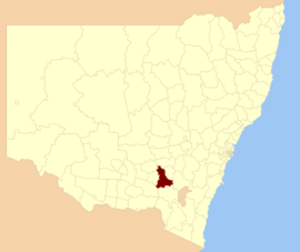 Boundaries of Gundagai Council formed 2016 | |||||||||||||||
| Coordinates | 34°48′S 148°7′E | ||||||||||||||
| Population | |||||||||||||||
| • Density | 2.7985/km2 (7.2482/sq mi) | ||||||||||||||
| Established | 12 May 2016 | ||||||||||||||
| Area | 3,981 km2 (1,537.1 sq mi)[3] | ||||||||||||||
| Mayor | Cr. Abb McAlister | ||||||||||||||
| Region | |||||||||||||||
| State electorate(s) | Cootamundra | ||||||||||||||
| Federal Division(s) | Riverina | ||||||||||||||
| Website | Cootamundra–Gundagai Regional Council | ||||||||||||||
| |||||||||||||||
The council has an area of 3,981 square kilometres (1,537 sq mi) and occupies the slopes of the western side of the Great Dividing Range between Yass and Tumut and to the north the beginning of the northern part of the Riverina plains. At the time of its establishment the council had an estimated population of 11,141.[1]
The mayor of the Cootamundra–Gundagai Regional Council is Councillor Abb McAlister, who was elected after the inaugural Cootamundra–Gundagai Regional Council election which was held on 9 September 2017.[4]
Controversy at creation
Around the same time as the state government was announcing the mergers of shires and councils, the mayor of the Gundagai Shire, Abb McAlister, lodged papers with the Land and Environment Court of New South Wales to prevent it.[5]
Signs protesting the amalgamation were prominently displayed throughout Gundagai for several years.
Towns and localities
The following towns and localities are located within Gundagai Council:
Demographics
The population for the predecessor councils was estimated in 2015 as:[6]
- 7,705 in Cootamundra Shire and
- 3,756 in Gundagai Shire.
Council
Once elected, the Gundagai Council will comprise nine Councillors elected proportionally in a single ward. All Councillors are expected to be elected for a fixed four-year term of office at elections to be held on 9 September 2017. In the meantime, Christine Ferguson was appointed as council administrator, and Ken Tretheway was appointed as Interim General Manager at creation of the new council.[3] Ferguson is a farmer in the Gundagai area and former state president of the National Party. She had also been a councillor of Gundagai Shire during the 1990s.[7]
References
- Australian Bureau of Statistics (27 June 2017). "Gundagai (A) (Local Government Area)". 2016 Census QuickStats. Retrieved 27 June 2017.

- "3218.0 – Regional Population Growth, Australia, 2017-18". Australian Bureau of Statistics. 27 March 2019. Retrieved 27 March 2019. Estimated resident population (ERP) at 30 June 2018.
- "Gundagai Council". Stronger Councils. Government of New South Wales. 12 May 2016. Archived from the original on 11 June 2016. Retrieved 21 May 2016.
- Grey, Lachlan (21 September 2017). "Abb McAlister to lead new Cootamundra-Gundagai council". Cootamundra Herald. Retrieved 21 September 2017.
- Morphet, Jack (13 May 2016). "COUNCIL MERGERS: Former Gundagai mayor takes on Baird government". The Daily Advertiser. Fairfax Regional Media. Retrieved 23 May 2016.
- "Regional Population Growth, Australia. Population Estimates by Local Government Area (ASGS 2015), 2005 to 2015 Table 1. Estimated Resident Population, Local Government Areas, New South Wales". 30 March 2016. Retrieved 21 May 2016.
- Jennette Lees (13 May 2016). "Former Nationals president to lead new Gundagai Council". Cootamundra Herald. Retrieved 23 May 2016.