Carrathool
Carrathool /ˈkærəθuːl/ is a village in the western Riverina region of New South Wales, Australia, in Carrathool Shire. In 2011 census, Carrathool had a population of 296 people.[1] It is about 5 kilometres (3 mi) north of the Sturt Highway between Darlington Point and Hay (on the opposite side of the Murrumbidgee River to the highway). The village is situated on the plain a few kilometres north of the river, clustered around the now-disused railway station.
| Carrathool New South Wales | |
|---|---|
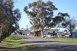 Wade St, the main street of Carrathool | |
Carrathool | |
| Coordinates | 34°25′0″S 145°26′0″E |
| Population | 238 (2016 census)[1] |
| Postcode(s) | 2711 |
| Elevation | 104 m (341 ft) |
| Location | |
| LGA(s) | Carrathool Shire |
| County | Sturt |
| State electorate(s) | Murray |
| Federal Division(s) | Riverina |
The place name Carrathool is derived from the local Aboriginal word meaning "Native Companion".[3]
History
Carrathool Reserve
In October 1852 a reserve of 4 1⁄2 square miles (12 km2) was proclaimed (No. 13 in the Lachlan Pastoral District); it was situated at the location known as Currathool on the north bank of the Murrumbidgee River "on a cattle run occupied by Mr. Rudd".[4]
The location of the original village of Carrathool — or ‘Currathool’ as it was often written — was at a river-crossing on the Murrumbidgee River at a place called Boree Point.
Carrathool Post Office opened on 20 June 1882.[5] Carrathool notably is sign posted on its outskirts "population 99" and for many years we hoped to reach 100, however with droughts and children often moving to larger centres this figure may never have been reached. The above census figures for 2006 would not relate to the township of carrathool and would not have a higher population than its neighbouring township of Goolgowi.
Heritage listings
Carrathool has a number of heritage-listed sites, including:
- 244 Main Road: Carrathool Bridge over Murrumbidgee River[6]
References
- Australian Bureau of Statistics (31 October 2012). "Carrathool (State Suburb)". 2011 Census QuickStats. Retrieved 30 March 2015.

- Travelmate Archived 24 March 2007 at the Wayback Machine
- "Carrathool". Geographical Names Register (GNR) of NSW. Geographical Names Board of New South Wales.
- New South Wales Government Gazette, No. 104, Monday, 25 October 1852, pp. 1549-1556.
- Premier Postal History, Post Office List
- "Carrathool Bridge over Murrumbidgee River". New South Wales State Heritage Register. Office of Environment and Heritage. H01460. Retrieved 18 May 2018.
External links
![]()