Sebastopol, New South Wales
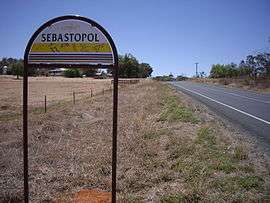
Sebastopol is a village community in the north east part of the Riverina. It is situated by road, about 15 kilometres south of Temora and 19 kilometres north of Junee Reefs.
| Sebastopol New South Wales | |
|---|---|
 Entering Sebastopol | |
Sebastopol | |
| Coordinates | 34°34′48″S 147°31′03″E |
| Postcode(s) | 2666 |
| Elevation | 299 m (981 ft) |
| Location |
|
| LGA(s) | Temora Shire |
| County | Clarendon |
| State electorate(s) | Cootamundra |
| Federal Division(s) | Riverina |
The village is located by signage on the Olympic Highway. Other than rural dwellings surrounding the village the only sign of a more prosperous past is a dilapidated building well past its prime and a well constructed brick Presbyterian church on the nearby Mimosa Road close to the intersection of Henrys Road.
It was named after Sevastopol, the site of an important battle during the Crimean War. Sebastopol Post Office opened on 7 March 1870 and closed in 1973.[1]
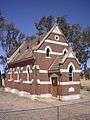 St Stephen's Church Sebastopol
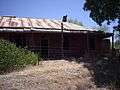 Ruins at Sebastopol
Notes and references
- Premier Postal History, Post Office List, retrieved 11 June 2009
| Wikimedia Commons has media related to Sebastopol, New South Wales. |
This article is issued from Wikipedia. The text is licensed under Creative Commons - Attribution - Sharealike. Additional terms may apply for the media files.