Womboota
Womboota is a locality in the centre south part of the Riverina. It is situated by road, about 26 kilometres (16 mi) north from Moama and 28 kilometres (17 mi) south west from Bunnaloo. At the 2016 census, Womboota had a population of 105.[1]
| Womboota New South Wales | |
|---|---|
 School of Arts hall | |
Womboota | |
| Coordinates | 35°57′25″S 144°35′19″E |
| Population | 105 (2016 census)[1] |
| Postcode(s) | 2731 |
| Elevation | 91 m (299 ft) |
| Location |
|
| LGA(s) | Murray River Council |
| County | Cadell |
| State electorate(s) | Murray |
| Federal Division(s) | Farrer |
Womboota is located in the Deniliquin land district and the Murray River Council and is on the Balranald branch line of the Deniliquin railway line.
Womboota Post Office opened on 1 July 1899 and closed in 1979.[2]
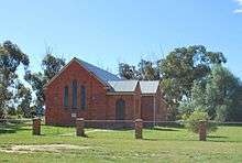 Womboota Uniting Church building
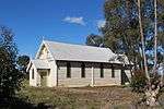 Womboota Roman Catholic Church building
References
- Australian Bureau of Statistics (27 June 2017). "Womboota (State Suburb)". 2016 Census QuickStats. Retrieved 26 June 2019.

- Premier Postal History, Post Office List, retrieved 11 April 2008
External links
![]()
This article is issued from Wikipedia. The text is licensed under Creative Commons - Attribution - Sharealike. Additional terms may apply for the media files.