Tweed Shire
Tweed Shire is a local government area located in the Northern Rivers region of New South Wales, Australia. The shire is located adjacent to the border with Queensland where it meets the Tasman Sea coast. The shire, administered from the town of Murwillumbah, covers an area of 1,321.0 square kilometres (510.0 sq mi), and has existed as a local government entity since 1947. It was named for the Tweed River.
| Tweed Shire New South Wales | |||||||||||||||
|---|---|---|---|---|---|---|---|---|---|---|---|---|---|---|---|
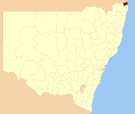 Location within New South Wales | |||||||||||||||
| Coordinates | 28°20′S 153°23′E | ||||||||||||||
| Population | |||||||||||||||
| • Density | 69.168/km2 (179.14/sq mi) | ||||||||||||||
| Established | 1906 | ||||||||||||||
| Area | 1,321 km2 (510.0 sq mi) | ||||||||||||||
| Mayor | Katie Milne | ||||||||||||||
| Council seat | Murwillumbah | ||||||||||||||
| Region | Northern Rivers | ||||||||||||||
| State electorate(s) | |||||||||||||||
| Federal Division(s) | Richmond | ||||||||||||||
| Website | Tweed Shire | ||||||||||||||
| |||||||||||||||
The current Mayor of Tweed Shire Council is Cr. Katie Milne [3] of The Greens.
History
The European history of the Tweed Shire began in 1823 when the Tweed River was explored by John Oxley. After sheltering on Cook Island, (4 km from the River's mouth), Oxely travelled 11 kilometres (6.8 mi) up river. In 1828, Captain H. J. Rous explored 50 kilometres (31 mi) up the river. Settlers began to arrive in 1828, the first of which were the cedar getters, who came to harvest Great Red Cedars and send them back to England.[4] During the height of the cedar logging industry, the Tweed Valley was one of the wealthiest districts in Australia.
The Municipality of Murwillumbah was created on 25 May 1902, and held its first meeting on 22 August 1902, at which Peter Street was elected its first Mayor. The Shire of Tweed, with its primary centre of population at Tumbulgum on the Tweed River, came into being in the surrounding area on 7 March 1906 with the enactment of the Local Government Act 1906 (NSW). On 1 January 1947, the two amalgamated to form Tweed Shire.[5]
Heritage listings
The Tweed Shire has a number of heritage-listed sites, including:
- Murwillumbah, Casino-Murwillumbah railway: Murwillumbah railway station[6]
- High Conservation Value Old Growth forest[7]
Towns and localities

- Tweed Heads
- Tweed Heads
- Banora Point
- Bilambil
- Bilambil Heights
- Chinderah
- Fingal Head
- Kingscliff
- Piggabeen
- Terranora
- Tweed Heads South
- Tweed Heads West
- Tweed Coast
- Murwillumbah
- Towns
- Other localities
- Brays Creek
- Bungalora
- Cedar Creek
- Carool
- Clothiers Creek
- Cobaki
- Cobaki Lakes
- Crystal Creek
- Cudgera Creek
- Doon Doon
- Dum Dum
- Dunbible
- Dungay
- Duroby
- Eungella
- Glengarrie
- Kielvale
- Kings Forest
- Kynnumboon
- Limpinwood
- Midginbil
- Mooball
- Mount Burrell
- Mount Warning
- Nobbys Creek
- North Arm
- Numinbah
- Pumpenbil
- Reserve Creek
- Stokers Siding
- Stotts Creek
- Terragon
- Tygalgah
- Upper Burringbar
- Upper Crystal Creek
- Upper Duroby
- Urilup
- Queensland
- Gold Coast Airport (Tweed Heads part)
Demographics
At the 2011 census, there were 85,105 people in the Tweed local government area, of these 48.2 per cent were male and 51.8 per cent were female. Aboriginal and Torres Strait Islander people made up 3.5 per cent of the population, which was significantly higher than the national and state averages of 2.5 per cent. The median age of people in the Tweed Shire area was 45 years, which was significantly higher than the national median of 37 years. Children aged 0 – 14 years made up 17.8 per cent of the population and people aged 65 years and over made up 22.9 per cent of the population. Of people in the area aged 15 years and over, 47.5 per cent were married and 15.3 per cent were either divorced or separated.[8]
Population growth in the Tweed Shire area between the 2001 census and the 2006 census was 7.45 per cent; and in the subsequent five years to the 2011 census, population growth was 7.29 per cent. When compared with total population growth of Australia for the same periods, being 5.78 per cent and 8.32 per cent respectively, population growth in the Tweed local government area was marginally higher than the national average.[9][10] The median weekly income for residents within the Tweed Shire area was significantly lower than the national average.[8]
At the 2011 census, the proportion of residents in the Tweed local government area who stated their ancestry as Australian or Anglo-Celtic exceeded 80 per cent of all residents (national average was 65.2 per cent). In excess of 59 per cent of all residents in the Tweed Shire nominated a religious affiliation with Christianity at the 2011 census, which was slightly higher than the national average of 50.2 per cent. Meanwhile, as at the census date, compared to the national average, households in the Tweed local government area had a significantly lower than average proportion (5.5 per cent) where two or more languages are spoken (national average was 20.4 per cent); and a significantly higher proportion (91.6 per cent) where English only was spoken at home (national average was 76.8 per cent).[8]
| Selected historical census data for the Tweed Shire local government area | |||||
|---|---|---|---|---|---|
| Census year | 2001[9] | 2006[10] | 2011[8] | ||
| Population | Estimated residents on Census night | 73,821 | 79,321 | 85,105 | |
| LGA rank in terms of size within New South Wales | 26 | ||||
| % of New South Wales population | 1.23% | ||||
| % of Australian population | 0.39% | ||||
| Cultural and language diversity | |||||
| Ancestry, top responses | English | 31.9% | |||
| Australian | 30.0% | ||||
| Irish | 9.8% | ||||
| Scottish | 8.0% | ||||
| German | 3.2% | ||||
| Language, top responses (other than English) | German | 0.4% | |||
| Italian | 0.3% | ||||
| French | n/c | ||||
| Japanese | n/c | ||||
| Spanish | n/c | n/c | |||
| Religious affiliation | |||||
| Religious affiliation, top responses | Catholic | 24.9% | |||
| Anglican | 29.0% | ||||
| No Religion | 13.8% | ||||
| Presbyterian and Reformed | 5.9% | ||||
| Uniting Church | 6.0% | ||||
| Median weekly incomes | |||||
| Personal income | Median weekly personal income | A$364 | A$442 | ||
| % of Australian median income | 78.1% | ||||
| Family income | Median weekly family income | A$904 | A$1,045 | ||
| % of Australian median income | 77.2% | ||||
| Household income | Median weekly household income | A$683 | A$845 | ||
| % of Australian median income | 66.5% | ||||
Council
In May 2005, the Governor of New South Wales dismissed the Tweed Shire Council following a public inquiry that found the Council was improperly influenced by developers involved in a property boom in the area. The inquiry was commissioned by the Minister for Local Government, Tony Kelly, following community concern about the way planning decisions were made. The Minister appointed the Director-general of the Department of Local Government, Garry Payne, former Sydney Lord Mayor Lucy Turnbull and former Tweed Shire councillor, Max Boyd as Administrators for the ensuing three years.[11]
Current composition and election method
Tweed Shire Council is composed of seven Councillors elected proportionally as one entire ward. The Councillors are elected for a fixed four-year term of office. The Mayor is elected by the Councillors at the first meeting of the Council. The most recent election was held on 29 October 2016, and the makeup of the Council is as follows:[12]
| Party | Councillors | |
|---|---|---|
| Independents | 4 | |
| Greens | 1 | |
| Country Labor | 1 | |
| Liberal | 1 | |
| Total | 7 | |
The current Council, elected in 2016, in order of election, is:[12]
| Councillor | Party | Notes | |
|---|---|---|---|
| Katie Milne | Greens | ||
| Warren Polglase | Independent | ||
| Pryce Allsop | Independent | ||
| James Owen | Liberal | ||
| Reece Byrnes | Country Labor | ||
| Chris Cherry | Independent | ||
| Ron Cooper | Independent | ||
Shire Presidents and Mayors
| Councillor | Term of office | Title |
|---|---|---|
| C E Cox | 1947–1948 | Provisional President |
| A Buckley | 1948–1949 | President |
| C E Cox | 1949–1957 | President |
| Harold Lundberg | 1957–1958 | President |
| Clarrie Hall | 1958–1959 | President |
| Harold Lundberg | 1959–1961 | President |
| Clarrie Hall | 1961–1963 | President |
| Harold Lundberg | 1963–1964 | President |
| Clarrie Hall | 1964–1973 | President |
| Charles Jarvis | 1973–1975 | President |
| Clarrie Hall | 1975–1979 died in office |
President |
| Max Boyd | 1979–1981 | President |
| Mrs Y A M Rowse | 1981–1984 | President |
| Max Boyd | 1984–1999 | President/Mayor |
| Lynne Beck | 1999–2001 | Mayor |
| Warren Polglase | 2001–2005 | Mayor |
| Garry Payne | 2005–2006 | Administrator |
| Frank Willan | 2006–2008 | Administrator |
| Max Boyd | 2005–2008 | Administrator |
| Lucy Turnbull | 2005–2007 | Administrator |
| Garry Payne | 2007–2008 | Administrator |
| Joan van Lieshout | 2008–2009 | Mayor |
| Warren Polglase | 2009–2010 | Mayor |
| Kevin Skinner | 2010–2011 | Mayor |
| Barry Longland | 2011–2014 | Mayor |
| Gary Bagnall | 2014–2015 | Mayor |
| Katie Milne | 2015– | Mayor |
References
- "3218.0 – Regional Population Growth, Australia, 2014–15". Australian Bureau of Statistics. Retrieved 29 September 2016.
- "3218.0 – Regional Population Growth, Australia, 2017-18". Australian Bureau of Statistics. 27 March 2019. Retrieved 27 March 2019. Estimated resident population (ERP) at 30 June 2018.
- Tweed Link, Issue 926 22 September 2015, page 1
- Collier's Encyclopedia. New York: Maxwell Macmillan Communication Group.
- Murwillumbah Historical Society Inc. (8 October 2009). "The Shire of Tweed". Archived from the original on 13 October 2009. Retrieved 3 December 2009.
- "Murwillumbah Railway Station and yard group". New South Wales State Heritage Register. Office of Environment and Heritage. H01206. Retrieved 18 May 2018.
- "High Conservation Value Old Growth forest". New South Wales State Heritage Register. Office of Environment and Heritage. H01487. Retrieved 18 May 2018.
- Australian Bureau of Statistics (31 October 2012). "Tweed Shire". 2011 Census QuickStats. Retrieved 10 April 2015.

- Australian Bureau of Statistics (9 March 2006). "Tweed (A)". 2001 Census QuickStats. Retrieved 22 May 2016.
- Australian Bureau of Statistics (25 October 2007). "Community Profile Series : Tweed (A) (Local Government Area)". 2006 Census of Population and Housing. Retrieved 27 October 2010.
- "Council sacked after property corruption probe". The Sydney Morning Herald. AAP. 25 May 2005. Retrieved 6 October 2012.
- "Tweed Shire Council: Summary of First Preference and Group Votes for each Candidate". Local Government Election 2016. New South Wales Electoral Commission. 3 November 2016. Retrieved 7 November 2012.