Mirrool Creek
Mirrool Creek, a watercourse[1] that is part of the Lachlan sub-catchment of the Murrumbidgee catchment in the Murray–Darling basin, is in the Riverina region of New South Wales, Australia. The course of the Mirrool Creek is indefinite at various locations.[1]

| Mirrool Merool[1] | |
|---|---|
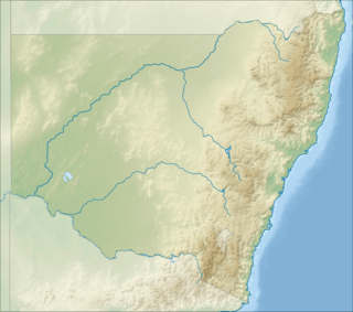 Location of Mirrool Creek mouth in New South Wales | |
| Etymology | Aboriginal: pipeclay[1] |
| Location | |
| Country | Australia |
| State | New South Wales |
| Region | Riverina (IBRA) |
| LGAs | Bland, Griffith, Carrathool, Hay |
| Town | Mirrool, Ardlethan, Griffith |
| Physical characteristics | |
| Source | Great Dividing Range |
| ⁃ location | west by south of Temora |
| ⁃ coordinates | 34°27′56″S 147°23′57″E |
| ⁃ elevation | 304 m (997 ft) |
| Mouth | Lachlan River |
⁃ location | northwest of Hay |
⁃ coordinates | 34°24′S 144°53′E |
⁃ elevation | 84 m (276 ft) |
| Length | 264 km (164 mi) |
| Basin features | |
| River system | Murrumbidgee catchment, Murray–Darling basin |
| Tributaries | |
| ⁃ left | Yarranjerry Creek, Little Mirrool Creek |
| ⁃ right | Mandamah Creek, Kildary Creek, Bolaro Creek, Wah Wah No 9 Channel |
| [2][3][4][5] | |
Course and features
Mirrool Creek (technically a river[1]) rises in the Ingalba Nature Reserve, about 15 kilometres (9.3 mi) west by south of the town of Temora, sourced by runoff from the Great Dividing Range. The creek flows generally north northwest, west, north by west, and west again for approximately 115 kilometres (71 mi), joined by four minor tributaries, before becoming indefinite approximately 3 kilometres (1.9 mi) south southwest of Barellan. The Mirrool Creek rises again approximately 20 kilometres (12 mi) east of Griffith and flows for approximately 75 kilometres (47 mi) west southwest, and to the south of Yenda, Bilbul, Hanwood and Griffith, before heading northwest by north and flowing into the Barren Box Swamp, where the creek does not drain above the land surface. The Mirrool Creek rises again southwest of the village of Goolgowi and flows west and then west southwest, joined by one minor tributary, before reaching its confluence with the Lachlan River, north northwest of the town of Hay. The creek descends 191 metres (627 ft) over the entire 264-kilometre (164 mi) course.[2][3][4]
The creek is crossed by the Newell Highway at the locality of Mirrool and at the town of Ardlethan; the Kidman Way south of Hanwood and north of Darlington Point; the Mid-Western Highway northeast of Hay; and the Cobb Highway northwest of Hay.[2][3]
References
- "Mirrool Creek". Geographical Names Register (GNR) of NSW. Geographical Names Board of New South Wales. Retrieved 3 January 2015.

- "Map of Mirrool Creek, NSW (1)". Bonzle Digital Atlas of Australia. Retrieved 3 January 2015.
- "Map of Mirrool Creek, NSW (2)". Bonzle Digital Atlas of Australia. Retrieved 3 January 2015.
- "Map of Mirrool Creek, NSW (3)". Bonzle Digital Atlas of Australia. Retrieved 3 January 2015.
- "Our partners: local government". Lachlan Catchment Management Authority. Government of New South Wales. 2013. Retrieved 3 January 2015.
External links
- "Lachlan River catchment" (map). Office of Environment and Heritage. Government of New South Wales.
- Trueman, Will (2012). True Tales of the Trout Cod: River Histories of the Murray–Darling Basin (Lachlan River catchment booklet) (PDF). Canberra: Murray–Darling Basin Authority. ISBN 978-1-921914-98-0. Archived from the original (PDF) on 25 February 2014.
Rivers of the Murrumbidgee River catchment, New South Wales and the Australian Capital Territory, Australia | |||||
|---|---|---|---|---|---|
| |||||
| |||||