Kamarah, New South Wales
Kamarah, is a village community in the central north part of the Riverina. It is situated by road, about 11 kilometres west of Ardlethan and 12 kilometres east of Moombooldool. At the 2006 census, Kamarah had a population of 130 people.[1]
| Kamarah New South Wales | |
|---|---|
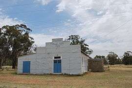 Kamarah public hall | |
Kamarah | |
| Coordinates | 34°22′5″S 146°45′39″E |
| Population | 130 (2006 census)[1] |
| Postcode(s) | 2665 |
| Elevation | 189 m (620 ft) |
| Location | |
| LGA(s) | Narrandera Shire |
| County | Cooper |
| State electorate(s) | Murrumbidgee |
| Federal Division(s) | Riverina |
Kamarah was previously named By Goo. Its current name comes from the local Aboriginal word for 'sleep'.[2]
Bygoo Post Office opened on 2 December 1910, was renamed Kamarah next year and closed in 1986.[3]
The railway line opened in 1908. The station closed in 1975, however the line remains open for goods trains.[4]
Notes and references
- Australian Bureau of Statistics (25 October 2007). "Kamarah (State Suburb)". 2006 Census QuickStats. Retrieved 11 October 2009.
- "Kamarah". Geographical Names Register (GNR) of NSW. Geographical Names Board of New South Wales.

- Premier Postal History, Post Office List, retrieved 11 June 2009
- Kamarah Station. NSWrail.net, accessed 10 November 2010.
External links
| Wikimedia Commons has media related to Kamarah, New South Wales. |
| Preceding station | NSW Branch lines | Following station | ||
|---|---|---|---|---|
towards Roto | Temora- Roto Line | Ardlethan towards Temora |
This article is issued from Wikipedia. The text is licensed under Creative Commons - Attribution - Sharealike. Additional terms may apply for the media files.