Wee Jasper, New South Wales
Wee Jasper is a village in the Goodradigbee valley at the western foot of the Brindabella Ranges, near Burrinjuck Dam in New South Wales, Australia in Yass Valley Shire.[2] It is located about 90 km north-west of Canberra and 60 km south-west of Yass. At the 2016 census, Wee Jasper and the surrounding area had a population of 100.[1]
| Wee Jasper New South Wales | |||||||||||||||
|---|---|---|---|---|---|---|---|---|---|---|---|---|---|---|---|
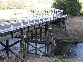 Bridge across the Goodradigbee River at Wee Jasper | |||||||||||||||
Wee Jasper | |||||||||||||||
| Coordinates | 35°06′0″S 148°40′0″E | ||||||||||||||
| Population | 100 (2016 census)[1] | ||||||||||||||
| Postcode(s) | 2582 | ||||||||||||||
| Elevation | 376–1,121 m (1,234–3,678 ft) | ||||||||||||||
| Location |
| ||||||||||||||
| LGA(s) | Yass Valley Council | ||||||||||||||
| County | Buccleuch | ||||||||||||||
| State electorate(s) | Goulburn | ||||||||||||||
| Federal Division(s) | Eden-Monaro | ||||||||||||||
| |||||||||||||||
| |||||||||||||||
History and description
Wee Jasper Post Office was first opened in January 1886 and closed in March 1892. Three years later, it was reopened again and remained in service until 1994.[3]
Near the village are several camping and recreation reserves close to numerous caves. The best known cave is Carey's Cave, a system of seven caverns lying just north of the town.[2] Others lie to the north and south, including Dip, Dogleg, Punch-bowl and Signature Caves.[2]
Fossils, including members of the Acanthothoracid placoderm fish family Weejasperaspididae, the primitive placoderm Brindabellaspis stensioi and the prehistoric lungfish, Dipnorhynchus cathlesae, have been found in the area.[4]
Heritage listings
Wee Jasper has a number of heritage-listed sites, including:
- 278 Main Road: Wee Jasper Bridge over Goodradigbee River[5]
Gallery
 Wee Jasper town sign
 The main bridge spanning the Goodradigbee River going into Wee Jasper
Climate
Wee Jasper yields a typical climate of the upper South West Slopes, akin to that of Batlow; comprising warm, stormy summers and cold, very wet winters with frequent and heavy snowfall.
Maximum temperatures are significantly cooler than regions of similar latitude and elevation in the Australian Capital Territory, owing to its windward position on the western slopes of the Brindabella Range.
| Climate data for Wee Jasper, NSW (Billapaloola State Forest); 808 m AMSL; 35° 16′ 00.12″ S | |||||||||||||
|---|---|---|---|---|---|---|---|---|---|---|---|---|---|
| Month | Jan | Feb | Mar | Apr | May | Jun | Jul | Aug | Sep | Oct | Nov | Dec | Year |
| Average high °C (°F) | 26.6 (79.9) |
25.6 (78.1) |
23.1 (73.6) |
17.1 (62.8) |
12.6 (54.7) |
9.3 (48.7) |
8.4 (47.1) |
9.8 (49.6) |
13.8 (56.8) |
16.6 (61.9) |
20.0 (68.0) |
24.3 (75.7) |
17.3 (63.1) |
| Average low °C (°F) | 12.1 (53.8) |
11.8 (53.2) |
9.8 (49.6) |
5.8 (42.4) |
3.2 (37.8) |
1.2 (34.2) |
0.1 (32.2) |
0.5 (32.9) |
2.4 (36.3) |
4.8 (40.6) |
7.2 (45.0) |
10.0 (50.0) |
5.7 (42.3) |
| Average precipitation mm (inches) | 86.9 (3.42) |
71.4 (2.81) |
98.8 (3.89) |
113.7 (4.48) |
163.4 (6.43) |
156.1 (6.15) |
172.6 (6.80) |
162.9 (6.41) |
132.6 (5.22) |
145.0 (5.71) |
120.1 (4.73) |
86.5 (3.41) |
1,510 (59.46) |
| Average precipitation days (≥ 0.2 mm) | 5.8 | 5.6 | 6.1 | 7.9 | 10.9 | 12.3 | 13.4 | 13.6 | 10.3 | 11.1 | 8.7 | 7.0 | 112.7 |
| Source: Australian Bureau of Meteorology; Billapaloola State Forest | |||||||||||||
References
- Australian Bureau of Statistics (27 June 2017). "Wee Jasper (State Suburb)". 2016 Census QuickStats. Retrieved 28 June 2017.

- Dow L, Guyon D, Irving R, McPhee M, Matthews A, Prineas P, Rubinich T, Simpson J (1995). Reader's Digest Illustrated Guide to Australian Places. Surry Hills, NSW: Reader's Digest. p. 209. ISBN 0-86438-399-1.
- Premier Postal History. "Post Office List". Retrieved 27 October 2009.
- Campbell, K.S.W.; R.E. Barwick (1999). "A New Species of the Devonian Lungfish Dipnorhynchus from Wee Jasper, New South Wales" (pdf). Records of the Australian Museum 51(2): 123–140. Australian Museum. Retrieved 30 January 2007.
- "Wee Jasper Bridge over Goodradigbee River". New South Wales State Heritage Register. Office of Environment and Heritage. H01485. Retrieved 18 May 2018.
| Wikimedia Commons has media related to Wee Jasper, New South Wales. |
| Towns and residential areas | |
|---|---|
| Localities |
|
Main Article: Local government areas of New South Wales | |