Koraleigh
Koraleigh is a small village in the west of the Riverina region of New South Wales, Australia. The village is on the Murray River and in Murray River Council local government area. Koraleigh is 6 kilometres (3.7 mi) northeast of Nyah, Victoria and 15 kilometres (9.3 mi) south of Tooleybuc.[2]
| Koraleigh New South Wales | |
|---|---|
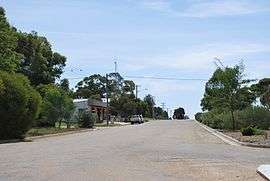 Main street | |
Koraleigh | |
| Coordinates | 35°07′S 143°26′E |
| Population | 373 (2006 census)[1] |
| Postcode(s) | 2735 |
| Location | |
| LGA(s) | Murray River Council |
| County | Wakool |
| State electorate(s) | Murray |
| Federal Division(s) | Farrer |
Koraleigh is on the traditional lands of the Muthi Muthi Aboriginal tribe and it is from their language that it gets its name.
At the 2006 census, Koraleigh had a population of 373.[1]
Koraleigh Post Office opened on 18 September 1922.[3] In the late 1980s, the Post Office moved from its original location in Eagles Lane and was integrated into the town's only store.
Gallery
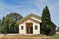 Public hall
 RFS shed
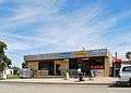 General store
References
- Australian Bureau of Statistics (25 October 2007). "Koraleigh (State Suburb)". 2006 Census QuickStats. Retrieved 20 October 2009.
- "Koraleigh". Geographical Names Register (GNR) of NSW. Geographical Names Board of New South Wales. Retrieved 4 August 2013.

- Premier Postal History, Post Office List, retrieved 11 June 2009
External links
![]()
This article is issued from Wikipedia. The text is licensed under Creative Commons - Attribution - Sharealike. Additional terms may apply for the media files.