Hay Shire
The Hay Shire is a local government area in the Riverina area of south-western New South Wales, Australia. The Shire comprises 11,326 square kilometres (4,373 sq mi) and is located adjacent to the Sturt, Mid-western and Cobb Highways. The area includes the towns of Hay, Booligal and Maude.
| Hay Shire New South Wales | |||||||||||||||
|---|---|---|---|---|---|---|---|---|---|---|---|---|---|---|---|
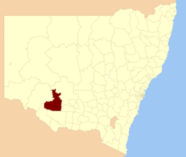 Location of Hay Shire in New South Wales | |||||||||||||||
| Coordinates | 34°30′S 144°51′E | ||||||||||||||
| Population |
| ||||||||||||||
| • Density | 0.26011/km2 (0.67369/sq mi) | ||||||||||||||
| Established | 1965 | ||||||||||||||
| Area | 11,325.89 km2 (4,373.0 sq mi)[3] | ||||||||||||||
| Mayor | Cr. Bill Sheaffe (Unaligned)[4] | ||||||||||||||
| Council seat | Hay | ||||||||||||||
| Region | Riverina | ||||||||||||||
| State electorate(s) | Murray | ||||||||||||||
| Federal Division(s) | Farrer | ||||||||||||||
| Website | Hay Shire | ||||||||||||||
| |||||||||||||||
Hay Shire was established in 1965 by the amalgamation of the Municipality of Hay with the surrounding Waradgery Shire.[5]
The mayor of Hay Shire is Cr. Bill Sheaffe, an unaligned politician.[4]
Council

Current composition and election method
Hay Shire Council is composed of eight councillors elected proportionally as a single ward. All councillors are elected for a fixed four-year term of office. The mayor is elected by the councillors at the first meeting of the Council. The most recent election was held on 10 September 2016, and the makeup of the Council is as follows:[6]
| Party | Councillors | |
|---|---|---|
| Independents and Unaligned | 8 | |
| Total | 8 | |
The current Council, elected in 2016, in order of election, is:[6]
| Councillor | Party | Notes | |
|---|---|---|---|
| Bill Sheaffe | Unaligned | Mayor[4] | |
| Kevin Walter | Unaligned | ||
| Peter Dwyer | Unaligned | ||
| Jasen Crighton | Unaligned | ||
| Michael Rutledge | Unaligned | Deputy Mayor[4] | |
| Dave Townsend | Independent | ||
| Robert Howard | Unaligned | ||
| Jenny Dwyer | Independent | ||
Literary reference
Banjo Paterson (1864–1941) wrote a poem called Hay and Hell and Booligal about the district.[7]
References
- Australian Bureau of Statistics (27 June 2017). "Hay (A)". 2016 Census QuickStats. Retrieved 8 December 2017.

- "3218.0 – Regional Population Growth, Australia, 2017-18". Australian Bureau of Statistics. 27 March 2019. Retrieved 27 March 2019. Estimated resident population (ERP) at 30 June 2018.
- "Hay Regional Profile". Riverina Regional Development Board. Archived from the original on 19 July 2008. Retrieved 28 August 2008.
- "Councillors & Staff". Hat Shire Council. Retrieved 5 November 2016.
- "Waradgery Shire Council". Search. State Records NSW. Retrieved 21 May 2016.
- "Hay Shire Council: Summary of First Preference and Group Votes for each Candidate". Local Government Elections 2016. Electoral Commission of New South Wales. 19 September 2016. Retrieved 5 November 2016.
- "Hay and Hell and Booligal". ghostwolf.dyndns.org. Archived from the original on 14 April 2013. Retrieved 6 September 2008.