Burrandana
Burrandana is a rural locality in the south eastern part of the Riverina. It is situated by road, about five kilometres (3.1 mi) east south-east of Pulletop[3] and nine kilometres (5.6 mi) north of Mangoplah.[4]
| Burrandana New South Wales | |
|---|---|
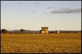 Burrandana railway station, 1985 | |
Burrandana Location in New South Wales | |
| Coordinates | 35°24′50″S 147°20′49″E |
| Population | 21 (2016 census)[1] |
| Postcode(s) | 2650 |
| Location | |
| LGA(s) | City of Wagga Wagga |
| County | Mitchell |
| State electorate(s) | Wagga Wagga |
References
- Australian Bureau of Statistics (27 June 2017). "Burrandana (State Suburb)". 2016 Census QuickStats. Retrieved 27 June 2017.

- Travelmate Archived 24 March 2007 at the Wayback Machine
- "Pulletop". Geographical Names Register (GNR) of NSW. Geographical Names Board of New South Wales.
- "Burrandana". Geographical Names Register (GNR) of NSW. Geographical Names Board of New South Wales.
External links
![]()
This article is issued from Wikipedia. The text is licensed under Creative Commons - Attribution - Sharealike. Additional terms may apply for the media files.