Khancoban
Khancoban (/kænˈkoʊbən/) is a small town in Snowy Valleys Council, New South Wales, Australia. The town is located 567 kilometres (352 mi) from the state capital, Sydney and 13 kilometres (8 mi) from the state border with Victoria, in the foothills of the Snowy Mountains, near the upper reaches of the Murray River. At the 2016 census, Khancoban had a population of 304.[1]
| Khancoban New South Wales | |||||||||
|---|---|---|---|---|---|---|---|---|---|
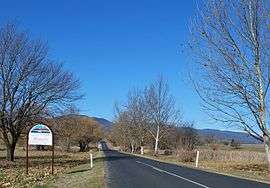 Entrance to Khancoban | |||||||||
Khancoban | |||||||||
| Coordinates | 36°13′12″S 148°07′37″E | ||||||||
| Population | 304 (2016 census)[1] | ||||||||
| Postcode(s) | 2642 | ||||||||
| Elevation | 337.0 m (1,106 ft) | ||||||||
| Location | |||||||||
| LGA(s) | Snowy Valleys Council | ||||||||
| County | Selwyn | ||||||||
| State electorate(s) | Albury | ||||||||
| Federal Division(s) | Eden-Monaro | ||||||||
| |||||||||
Khancoban Post Office opened on 7 November 1876.[2]
Tourism
The town is a popular launching place for tourists exploring the Snowy Mountains area including Kosciuszko National Park. Khancoban is linked to Jindabyne and Cooma by the Alpine Way, a scenic route that takes travellers past the ski resort of Thredbo. The closest regional centre is Corryong, 20 kilometres (12 mi) to the west in Victoria.
Economy
Khancoban was constructed to house workers involved in the Snowy Mountains Scheme, Australia's largest engineering project, designed to provide hydro-electric power and water for irrigation to vast areas of the nation. The town is still mainly populated by workers employed by Snowy Hydro Limited working in places such as Murray 1 and Murray 2 Power Stations.
Climate
Khancoban has a typical climate of the South West Slopes, with four distinct seasons. It is characterised by its inland location and likewise windward position (west of the Snowy Mountains); with the summers having a high diurnal range, and relatively low humidity and rainfall amount—although thunderstorms usually increase humidity in summer somewhat. Winters are cool and very rainy, with occasional snowfalls, and a much narrower diurnal range due to frequent cloud cover. Autumns are mild and dry, with crisp nights. Springs are mild, albeit tepid by November, and damp with a high frequency of thunderstorms.
| Climate data for Khancoban AWS (1996–2020); 339 m AMSL; 36° 13′ 49.44″ S | |||||||||||||
|---|---|---|---|---|---|---|---|---|---|---|---|---|---|
| Month | Jan | Feb | Mar | Apr | May | Jun | Jul | Aug | Sep | Oct | Nov | Dec | Year |
| Record high °C (°F) | 43.3 (109.9) |
43.3 (109.9) |
38.0 (100.4) |
32.5 (90.5) |
25.4 (77.7) |
20.0 (68.0) |
19.0 (66.2) |
22.1 (71.8) |
28.0 (82.4) |
33.8 (92.8) |
38.0 (100.4) |
41.1 (106.0) |
43.3 (109.9) |
| Average high °C (°F) | 31.9 (89.4) |
30.5 (86.9) |
27.2 (81.0) |
21.8 (71.2) |
16.0 (60.8) |
12.2 (54.0) |
11.6 (52.9) |
13.6 (56.5) |
17.2 (63.0) |
21.1 (70.0) |
25.3 (77.5) |
28.4 (83.1) |
21.4 (70.5) |
| Average low °C (°F) | 13.7 (56.7) |
13.4 (56.1) |
10.7 (51.3) |
7.2 (45.0) |
4.2 (39.6) |
2.0 (35.6) |
1.7 (35.1) |
2.5 (36.5) |
4.5 (40.1) |
6.4 (43.5) |
9.5 (49.1) |
11.4 (52.5) |
7.3 (45.1) |
| Record low °C (°F) | 4.0 (39.2) |
3.0 (37.4) |
−2.0 (28.4) |
−1.4 (29.5) |
−4.0 (24.8) |
−4.2 (24.4) |
−4.6 (23.7) |
−5.0 (23.0) |
−7.0 (19.4) |
−1.3 (29.7) |
0.0 (32.0) |
2.2 (36.0) |
−7.0 (19.4) |
| Average precipitation mm (inches) | 50.5 (1.99) |
60.6 (2.39) |
61.5 (2.42) |
53.8 (2.12) |
68.1 (2.68) |
91.2 (3.59) |
89.6 (3.53) |
104.2 (4.10) |
84.9 (3.34) |
68.6 (2.70) |
89.2 (3.51) |
77.8 (3.06) |
900.0 (35.43) |
| Average precipitation days (≥ 0.2 mm) | 7.3 | 7.9 | 8.5 | 8.6 | 14.7 | 19.6 | 20.0 | 18.2 | 14.0 | 11.0 | 11.0 | 9.8 | 150.6 |
| Source: Australian Bureau of Meteorology; Khancoban AWS | |||||||||||||
Gallery
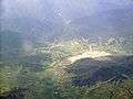 Aerial photo
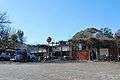 Khancoban Hotel
 Community hall
References
- Australian Bureau of Statistics (27 June 2017). "Khancoban (state suburb)". 2016 Census QuickStats. Retrieved 29 June 2016.

- Premier Postal History, Post Office List, retrieved 11 June 2009
External links
![]()
- Tumbarumba Shire Council - Official Site
- Koscuiszko National Park - NPWS site
- Snowy Mountains Tourist Site
- Snowy Hydro Limited - Official Site