Upper Hunter Shire
The Upper Hunter Shire is a local government area in the Upper Hunter Region of New South Wales, Australia. The Shire was formed in May 2004 from the Scone Shire and parts of Murrurundi and Merriwa shires.
| Upper Hunter Shire New South Wales | |||||||||||||||
|---|---|---|---|---|---|---|---|---|---|---|---|---|---|---|---|
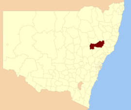 Location in New South Wales | |||||||||||||||
| Coordinates | 32°05′S 150°51′E | ||||||||||||||
| Population |
| ||||||||||||||
| • Density | 1.8/km2 (4.7/sq mi) | ||||||||||||||
| Area | 8,096 km2 (3,125.9 sq mi)[3] | ||||||||||||||
| Time zone | AEST (UTC+10) | ||||||||||||||
| • Summer (DST) | AEDT (UTC+11) | ||||||||||||||
| Mayor | Wayne Bedggood[4] | ||||||||||||||
| Council seat | Scone | ||||||||||||||
| Region | Hunter[5] | ||||||||||||||
| State electorate(s) | Upper Hunter[6] | ||||||||||||||
| Federal Division(s) | |||||||||||||||
| Website | Upper Hunter Shire | ||||||||||||||
| |||||||||||||||
The Mayor of the Upper Hunter Shire Council is Cr. Maurice Collison, following the sudden resignation of Wayne Bedggood as Mayor and as a Councillor on 9th June 2020. No reason has been given for the sudden resignation.[4]
Towns
The towns of the Upper Hunter are Scone, Aberdeen, Murrurundi, and Merriwa, as well as several villages, including Bunnan, Gundy, Moonan Flat, Ellerston, Wingen, Blandford and Cassilis. Of the towns, only Aberdeen on the Shire's south eastern border is situated on the Hunter River.
Heritage listings
The Upper Hunter Shire has a number of heritage-listed sites, including:
- Ardglen, Main Northern railway: Ardglen Tunnel[7]
- Merriwa, Bow Street: Colonial Cottage Museum[8]
- Murrurundi, Main Northern railway: Murrurundi railway station[9]
- Murrurundi, Mount Street: Rosedale Cottage[10]
- Scone, 144 Kelly Street: Scone Civic Theatre[11]
- Scone, 41 Kingdon Road: Old Court Theatre[12]
- Scone, Main Northern railway: Scone railway station[13]
- Wingen, Raglan Street: Mountain House, Wingen[14]
Demographics
At the 2011 census, there were 13,754 people in the Upper Hunter Shire local government area, of these 49.9 per cent were male and 50.1 per cent were female. Aboriginal and Torres Strait Islander people made up 3.9 per cent of the population, which was higher than the national and state averages of 2.5 per cent. The median age of people in the Upper Hunter Shire was 39 years, which was marginally higher than the national median of 37 years. Children aged 0 – 14 years made up 21.2 per cent of the population and people aged 65 years and over made up 16.4 per cent of the population. Of people in the area aged 15 years and over, 51.6 per cent were married and 11.6 per cent were either divorced or separated.[15]
Population growth in the Upper Hunter Shire between the 2006 census and the 2011 census was 6.00 per cent. When compared with total population growth of Australia for the same period, being 8.32 per cent, population growth in the Upper Hunter Shire local government area was slightly lower than the national average.[16] The median weekly income for residents within the Upper Hunter Shire was marginally lower than the national average.[15]
At the 2011 census, the proportion of residents in the Upper Hunter Shire local government area who stated their ancestry as Australian or Anglo-Saxon exceeded 85 per cent of all residents (national average was 65.2 per cent). In excess of 75% of all residents in the Upper Hunter Shire nominated a religious affiliation with Christianity at the 2011 census, which was considerably higher than the national average of 50.2 per cent. Meanwhile, as at the census date, compared to the national average, households in the Upper Hunter Shire local government area had a significantly lower than average proportion (3.1 per cent) where two or more languages are spoken (national average was 20.4 per cent); and a significantly higher proportion (93.9 per cent) where English only was spoken at home (national average was 76.8 per cent).[15]
| Selected historical census data for the Upper Hunter Shire local government area | |||||
|---|---|---|---|---|---|
| Census year | 2001 | 2006[16] | 2011[15] | ||
| Population | Estimated residents on Census night | n/a | 12,976 | 13,754 | |
| LGA rank in terms of size within New South Wales | |||||
| % of New South Wales population | 0.20% | ||||
| % of Australian population | n/a | 0.07% | |||
| Cultural and language diversity | |||||
| Ancestry, top responses | Australian | 36.6% | |||
| English | 32.4% | ||||
| Irish | 8.2% | ||||
| Scottish | 7.9% | ||||
| German | 2.8% | ||||
| Language, top responses (other than English) | Mandarin | ||||
| Portuguese | n/c | ||||
| Cantonese | 0.2% | ||||
| Arabic | n/c | ||||
| Tagalog | 0.1% | ||||
| Religious affiliation | |||||
| Religious affiliation, top responses | Anglican | 41.3% | |||
| Catholic | 27.2% | ||||
| No Religion | 9.7% | ||||
| Uniting Church | 4.4% | ||||
| Presbyterian and Reformed | |||||
| Median weekly incomes | |||||
| Personal income | Median weekly personal income | A$438 | A$552 | ||
| % of Australian median income | 94.0% | ||||
| Family income | Median weekly family income | A$1,090 | A$1,392 | ||
| % of Australian median income | 93.1% | ||||
| Household income | Median weekly household income | A$882 | A$1,071 | ||
| % of Australian median income | 85.9% | ||||
Council
Current composition and election method
Upper Hunter Shire Council is composed of nine Councillors elected proportionally as a single ward. All Councillors are elected for a fixed four-year term of office. The Mayor is elected by the Councillors at the first meeting of the Council. The most recent election was held on 10 September 2016 and the makeup of the Council is as follows:[17]
| Party | Councillors | |
|---|---|---|
| Independents and Unaligned | 8 | |
| Country Labor | 1 | |
| Total | 9 | |
At the 2016 election there were 10,094 people enrolled to vote in the local government area. The current Council, elected in 2016, in order of election, is:[17]
| Councillor | Votes | % | |
|---|---|---|---|
| Lee Watts | 2,163 | 27.29% | |
| Maurice Collison | 1,089 | 13.74% | |
| Wayne Bedggood | 916 | 11.56% | |
| Ron Campbell | 653 | 8.24% | |
| Sue Abbott | 598 | 7.55% | |
| Josh Brown | 540 | 6.81% | |
| Lorna Driscoll | 492 | 6.21% | |
| Kiwa Fisher | 459 | 5.79% | |
| James Burns | 378 | 4.77% | |
Attractions
The Upper Hunter is the largest horse-rearing region in Australia.
The Burning Mountain Nature Reserve, near Wingen, is the site of a subterranean coal seam fire that has been burning for several thousand years.[18]
The council also owns several FM rebroadcasters of ABC Radio National and SBS Radio, under the self-help schemes run by those broadcasters.
References
- Australian Bureau of Statistics (27 June 2017). "Upper Hunter Shire (A)". 2016 Census QuickStats. Retrieved 27 November 2017.

- "3218.0 – Regional Population Growth, Australia, 2017-18". Australian Bureau of Statistics. 27 March 2019. Retrieved 27 March 2019. Estimated resident population (ERP) at 30 June 2018.
- Australian Bureau of Statistics (31 October 2012). "2011 Community Profiles: Upper Hunter Shire (Local Government Area)". 2011 Census of Population and Housing. Retrieved 13 October 2012.
- "New mayor and Deputy Mayor for Upper Hunter Shire".
- "Suburb Search – Local Council Boundaries – Hunter (HT) – Upper Hunter Shire Council". New South Wales Division of Local Government. Retrieved 13 October 2012.
- "Upper Hunter". New South Wales Electoral Commission. Retrieved 23 November 2019.
- "Ardglen Tunnel". New South Wales State Heritage Register. Office of Environment and Heritage. H01021. Retrieved 18 May 2018.
- "Cottage Museum". New South Wales State Heritage Register. Office of Environment and Heritage. H00259. Retrieved 18 May 2018.
- "Murrurundi Railway Station group". New South Wales State Heritage Register. Office of Environment and Heritage. H01205. Retrieved 18 May 2018.
- "Rosedale Cottage". New South Wales State Heritage Register. Office of Environment and Heritage. H00421. Retrieved 18 May 2018.
- "Scone Civic Theatre". New South Wales State Heritage Register. Office of Environment and Heritage. H01660. Retrieved 18 May 2018.
- "Old Court Theatre". New South Wales State Heritage Register. Office of Environment and Heritage. H00340. Retrieved 18 May 2018.
- "Scone Railway Station". New South Wales State Heritage Register. Office of Environment and Heritage. H01242. Retrieved 18 May 2018.
- "Mountain House". New South Wales State Heritage Register. Office of Environment and Heritage. H00311. Retrieved 18 May 2018.
- Australian Bureau of Statistics (31 October 2012). "Upper Hunter Shire (Local Government Area)". 2011 Census QuickStats. Retrieved 13 October 2012.
- Australian Bureau of Statistics (25 October 2007). "Upper Hunter (A)". 2006 Census QuickStats. Retrieved 23 December 2013.
- "Upper Hunter Shire Council: Summary of First Preference and Group Votes for each Candidate". Local Government Elections 2016. Electoral Commission of New South Wales. 17 September 2016. Retrieved 20 October 2016.
- Krajick, Kevin (May 2005). "Fire in the hole". Smithsonian magazine: 54ff. Retrieved 13 October 2012.