Queanbeyan–Palerang Regional Council
Queanbeyan–Palerang Regional Council is a local government area located in the Southern Tablelands region of New South Wales, Australia. The council was formed on 12 May 2016 through a merger of the City of Queanbeyan and Palerang Council.[3]
| Queanbeyan–Palerang Regional Council New South Wales | |||||||||||||||
|---|---|---|---|---|---|---|---|---|---|---|---|---|---|---|---|
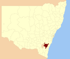 Location in NSW | |||||||||||||||
| Coordinates | 35°25′S 149°27′E | ||||||||||||||
| Population |
| ||||||||||||||
| • Density | 10.5334/km2 (27.2813/sq mi) | ||||||||||||||
| Established | 12 May 2016 | ||||||||||||||
| Area | 5,319 km2 (2,053.7 sq mi)[3] | ||||||||||||||
| Mayor | Tim Overall | ||||||||||||||
| Council seat | Queanbeyan Town Centre | ||||||||||||||
| Region | |||||||||||||||
| State electorate(s) | Monaro | ||||||||||||||
| Federal Division(s) | Eden-Monaro | ||||||||||||||
| Website | Queanbeyan–Palerang Regional Council | ||||||||||||||
| |||||||||||||||
The council has an area of 5,319 square kilometres (2,054 sq mi) and lies between the eastern boundary of the Australian Capital Territory and the coastal escarpment on both sides of the Great Dividing Range. At the time of its establishment the council had an estimated population of 56,368.[3]
Following the election on 9 September 2017, Tim Overall was elected Mayor of Queanbeyan–Palerang Regional Council.[4] Overall was the last Mayor of the Queanbeyan City Council, as an independent, prior to the merger with Palerang.
Towns and localities
The Queanbeyan urban area contains the following localities
- Crestwood
- Environa
- Googong
- Greenleigh
- Jerrabomberra
- Karabar
- Queanbeyan East
- Queanbeyan West
- Queanbeyan Town Centre
- The Ridgeway
- Royalla
- Tralee
The balance of the Queanbeyan–Palerang Regional Council area contains the towns of:
- Braidwood
- Bungendore
It also contains the following localities:
- Araluen
- Back Creek
- Ballalaba
- Bendoura
- Berlang
- Bombay
- Boro
- Budawang
- Burra
- Bywong
- Carwoola
- Captains Flat
- Charleys Forest
- Corang
- Currawang
- Durran Durra
- Farringdon
- Forbes Creek
- Harolds Cross
- Hereford Hall
- Hoskinstown
- Jembaicumbene
- Jerrabattgulla
- Jinden
- Kindervale
- Krawarree
- Lake George
- Larbert
- Majors Creek
- Manar
- Marlowe
- Mayfield
- Monga
- Mongarlowe
- Mount Fairy
- Mulloon
- Neringla
- Nerriga
- Northangera
- Oallen (part)
- Palerang
- Primrose Valley
- Reidsdale
- Rossi
- Royalla
- Snowball
- Sutton (part)
- Tarago (part)
- Tinderry (part)
- Tomboye
- Urila
- Wamboin
- Warri
- Williamsdale
- Wog Wog
- Wyanbene
- Yarrow
Demographics
The population for the predecessor councils was estimated in 2015 as:[5]
- 40,657 in City of Queanbeyan and
- 15,897 in Palerang Council
Council
Queanbeyan–Palerang Regional Council comprises eleven Councillors elected proportionally in a single ward. All Councillors have been elected for a fixed four-year term of office with effect from 9 September 2017.[4]
References
- Australian Bureau of Statistics (27 June 2017). "Queanbeyan-Palerang Regional (A)". 2016 Census QuickStats. Retrieved 21 July 2017.

- "3218.0 – Regional Population Growth, Australia, 2017-18". Australian Bureau of Statistics. 27 March 2019. Retrieved 27 March 2019. Estimated resident population (ERP) at 30 June 2018.
- "Queanbeyan-Palerang Regional Council". Stronger Councils. Government of New South Wales. 12 May 2016. Retrieved 21 May 2016.
- "Local representatives". Queanbeyan–Palerang Regional Council. Retrieved 2 November 2017.
- "Regional Population Growth, Australia. Population Estimates by Local Government Area (ASGS 2015), 2005 to 2015 Table 1. Estimated Resident Population, Local Government Areas, New South Wales". 30 March 2016. Retrieved 21 May 2016.
| Queanbeyan suburbs |
|
|---|---|
| Localities and rural places |
|
Main Article: Local government areas of New South Wales | |