Volga
The Volga (/ˈvɒlɡə, ˈvoʊlɡə/; Russian: Во́лга, IPA: [ˈvoɫɡə] (![]()
| Volga | |
|---|---|
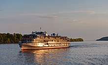
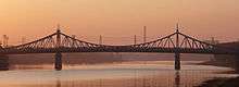
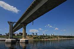
 The Volga at Ulyanovsk | |
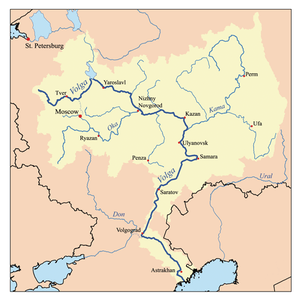 Map of the Volga drainage basin | |
| Native name | Волга |
| Location | |
| Country | Russia |
| Cities | Tver, Yaroslavl, Nizhny Novgorod, Cheboksary, Kazan, Ulyanovsk, Samara, Saratov, Volgograd, Astrakhan |
| Physical characteristics | |
| Source | |
| • location | Valdai Hills, Tver Oblast |
| • coordinates | 57°9′N 32°36′E |
| • elevation | 228[1] m (748 ft) |
| Mouth | Caspian Sea |
• location | Astrakhan Oblast |
• coordinates | 45°50′N 47°58′E[2] |
• elevation | −28[1] m (−92 ft) |
| Length | 3,531 km (2,194 mi)[3] |
| Basin size | 1,360,000 km2 (530,000 sq mi)[3] |
| Discharge | |
| • location | Astrakhan |
| • average | 8,060 m3/s (285,000 cu ft/s) |
| Basin features | |
| Tributaries | |
| • left | Kama |
| • right | Oka |
The river flows in Russia through forests, forest-steppes and steppes. Eleven of the twenty largest cities of Russia, including the capital, Moscow, are located in the Volga's drainage basin.
Some of the largest reservoirs in the world are located along the Volga. The river has a symbolic meaning in Russian culture and is often referred to as Волга-матушка Volga-Matushka (Mother Volga) in Russian literature and folklore.
Nomenclature
The Russian hydronym Volga (Волга) derives from Proto-Slavic *vòlga "wetness, moisture", which is preserved in many Slavic languages, including Ukrainian volóha (воло́га) "moisture", Russian vlaga (влага) "moisture", Bulgarian vlaga (влага) "moisture", Czech vláha "dampness", Serbian vlaga (влага) "moisture", Croatian vlaga "moisture" and Slovene vlaga "moisture" among others.[8]
The Slavic name is a loan translation of earlier Scythian Rā (Ῥᾶ) "Volga",[9] literally "wetness", cognate with Avestan Raŋhā "mythical stream" (also compare the derivation Sogdian r’k "vein, blood vessel" (*raha-ka),[10] Persian رگ rag "vein"[11]) and Vedic Sanskrit rasā́ (रसा) "dew, liquid, juice; mythical river".[12] The Scythian name survives in modern Mordvin Rav (Рав) "Volga".
The Turkic peoples living along the river formerly referred to it as Itil or Atil. In modern Turkic languages, the Volga is known as İdel (Идел) in Tatar, Атăл (Atăl) in Chuvash, Idhel in Bashkir, Edil in Kazakh, and İdil in Turkish. The Turkic names go back to the ancient Turkic form “Etil/ Ertil”, the origin and meaning of which are not clear. Perhaps this form has a connection with the hydronym Irtesh.[13]
The Turkic peoples associated the Itil's origin with the Kama. Thus, a left tributary to the Kama was named the Aq Itil "White Itil" which unites with the Kara Itil "Black Itil" at the modern city of Ufa. The name Indyl (Indɨl) is used in Adyge (Cherkess) language.
Among Asians, the river was known by its other Turkic name Sarı-su "yellow water", but the Oirats also used their own name, Ijil mörön or "adaptation river". Presently the Mari, another Uralic group, call the river Jul (Юл), meaning "way" in Tatar. Formerly, they called the river Volgydo, a borrowing from Old East Slavic.
Description
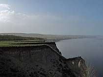
The Volga is the longest river in Europe, and its catchment area is almost entirely inside Russia, though the longest river in Russia is the Ob–Irtysh river system.[1] It belongs to the closed basin of the Caspian Sea, being the longest river to flow into a closed basin. Rising in the Valdai Hills 225 meters (738 ft) above sea level northwest of Moscow and about 320 kilometers (200 mi) southeast of Saint Petersburg, the Volga heads east past Lake Sterzh, Tver, Dubna, Rybinsk, Yaroslavl, Nizhny Novgorod, and Kazan. From there it turns south, flows past Ulyanovsk, Tolyatti, Samara, Saratov and Volgograd, and discharges into the Caspian Sea below Astrakhan at 28 meters (92 ft) below sea level.[1] At its most strategic point, it bends toward the Don ("the big bend"). Volgograd, formerly Stalingrad, is located there.
.jpg)
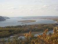
The Volga has many tributaries, most importantly the rivers Kama, the Oka, the Vetluga, and the Sura. The Volga and its tributaries form the Volga river system, which flows through an area of about 1,350,000 square kilometres (521,238 square miles) in the most heavily populated part of Russia.[1] The Volga Delta has a length of about 160 kilometres (99 miles) and includes as many as 500 channels and smaller rivers. The largest estuary in Europe, it is the only place in Russia where pelicans, flamingos, and lotuses may be found. The Volga freezes for most of its length for three months each year.[1]
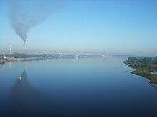
The Volga drains most of Western Russia. Its many large reservoirs provide irrigation and hydroelectric power. The Moscow Canal, the Volga–Don Canal, and the Volga–Baltic Waterway form navigable waterways connecting Moscow to the White Sea, the Baltic Sea, the Caspian Sea, the Sea of Azov and the Black Sea. High levels of chemical pollution have adversely affected the river and its habitats.
The fertile river valley provides large quantities of wheat, and also has many mineral riches. A substantial petroleum industry centers on the Volga valley. Other resources include natural gas, salt, and potash. The Volga Delta and the Caspian Sea are fishing grounds. Astrakhan, at the delta, is the center of the caviar industry.
Confluences (downstream to upstream)
- Akhtuba (near Volzhsky), a distributary
- Bolshoy Irgiz (near Volsk)
- Samara (in Samara)
- Kama (south of Kazan)
- Kazanka (in Kazan)
- Sviyaga (west of Kazan)
- Vetluga (near Kozmodemyansk)
- Sura (in Vasilsursk)
- Kerzhenets (near Lyskovo)
- Oka (in Nizhny Novgorod)
- Uzola (near Balakhna)
- Unzha (near Yuryevets)
- Kostroma (in Kostroma)
- Kotorosl (in Yaroslavl)
- Sheksna (in Cherepovets)
- Mologa (near Vesyegonsk)
- Kashinka (near Kalyazin)
- Nerl (near Kalyazin)
- Medveditsa (near Kimry)
- Dubna (in Dubna)
- Shosha (near Konakovo)
- Tvertsa (in Tver)
- Vazuza (in Zubtsov)
- Selizharovka (in Selizharovo)
Reservoirs (downstream to upstream)
A number of large hydroelectric reservoirs were constructed on the Volga during the Soviet era. They are:
- Volgograd Reservoir
- Saratov Reservoir
- Kuybyshev Reservoir – the largest in Europe by surface
- Cheboksary Reservoir
- Gorky Reservoir
- Rybinsk Reservoir
- Uglich Reservoir
- Ivankovo Reservoir
Biggest cities on the shores of the Volga
Human history

The area downstream of the Volga is widely believed to have been a cradle of the Proto-Indo-European civilization. The river ranges from the Caspian Sea, where especially Asian-Oriental cultures (Turkic, Caucasian and Persian) at that time were already widespread in steppe regions, to the northern lands in western Russia where in the East European Plain Slavic culture existed with Germanic and Finno-Ugric tribes. More precisely, the area around the Volga was inhabited by the Slavic tribes of Vyatichs and Buzhans, by Finno-Ugrics, Scandinavians and Balts, by Huns and Turkic peoples (Tatars, Kipchaks) in the first millennium AD, replacing the Scythians.[14] Furthermore, the river played a vital role in the commerce of the Byzantine people. The ancient scholar Ptolemy of Alexandria mentions the lower Volga in his Geography (Book 5, Chapter 8, 2nd Map of Asia). He calls it the Rha, which was the Scythian name for the river. Ptolemy believed the Don and the Volga shared the same upper branch, which flowed from the Hyperborean Mountains. Between 2nd and 5th centuries Baltic people were very widespread in today's European Russia. Baltic people were widespread from Sozh River till today's Moscow and covered much of today's Central Russia and intermingled with the East Slavs.[15] The Russian ethnicity in Western Russia and around the Volga river evolved to a very large extent, next to other tribes, out of the East Slavic tribe of the Buzhans and Vyatichis. The Vyatichis were originally concentrated on the Oka river.[16] Furthermore, several localities in Russia are connected to the Slavic Buzhan tribe, like for example Sredniy Buzhan in the Orenburg Oblast, Buzan and the Buzan river in the Astrakhan Oblast.[17][18] Buzhan (Persian: بوژان, also Romanized as Būzhān; also known as Būzān) is also a village in Nishapur, Iran.
Subsequently, the river basin played an important role in the movements of peoples from Asia to Europe. A powerful polity of Volga Bulgaria once flourished where the Kama joins the Volga, while Khazaria controlled the lower stretches of the river. Such Volga cities as Atil, Saqsin, or Sarai were among the largest in the medieval world. The river served as an important trade route connecting Scandinavia, Finno-Ugric areas with the various Slavic tribes and Turkic, Germanic, Finnic and other people in Old Rus', and Volga Bulgaria with Khazaria, Persia and the Arab world.
_-_Volga_Boatmen_(1870-1873).jpg)
From 6th till 8th century the Alans settled in the Middle Volga region and in the steppes of Russias southern region in the Pontic–Caspian steppe.[19]
Khazars were replaced by Kipchaks, Kimeks and Mongols, who founded the Golden Horde in the lower reaches of the Volga. Later their empire divided into the Khanate of Kazan and Khanate of Astrakhan, both of which were conquered by the Russians in the course of the 16th century Russo-Kazan Wars. The Russian people's deep feeling for the Volga echoes in national culture and literature, starting from the 12th-century Lay of Igor's Campaign.[20] The Volga Boatman's Song is one of many songs devoted to the national river of Russia.
Construction of Soviet Union-era dams often involved enforced resettlement of huge numbers of people, as well as destruction of their historical heritage. For instance, the town of Mologa was flooded for the purpose of constructing the Rybinsk Reservoir (then the largest artificial lake in the world). The construction of the Uglich Reservoir caused the flooding of several monasteries with buildings dating from the 15th and 16th centuries. In such cases the ecological and cultural damage often outbalanced any economic advantage.[21]
20th-century conflicts
During the Russian Civil War, both sides fielded warships on the Volga. In 1918, the Red Volga Flotilla participated in driving the Whites eastward, from the Middle Volga at Kazan to the Kama and eventually to Ufa on the Belaya.[22]
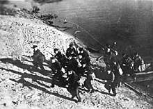
In modern times, the city on the big bend of the Volga, currently known as Volgograd, witnessed the Battle of Stalingrad, possibly the bloodiest battle in human history, in which the Soviet Union and the German forces were deadlocked in a stalemate battle for access to the river. The Volga was (and still is) a vital transport route between central Russia and the Caspian Sea, which provides access to the oil fields of the Apsheron Peninsula. Hitler planned to use access to the oil fields of Azerbaijan to fuel future German conquests. Apart from that, whoever held both sides of the river could move forces across the river, to defeat the enemy's fortifications beyond the river.[23] By taking the river, Hitler's Germany would have been able to move supplies, guns, and men into the northern part of Russia. At the same time, Germany could permanently deny this transport route by the Soviet Union, hampering its access to oil and to supplies via the Persian Corridor.
For this reason, many amphibious military assaults were brought about in an attempt to remove the other side from the banks of the river. In these battles, the Soviet Union was the main offensive side, while the German troops used a more defensive stance, though much of the fighting was close quarters combat, with no clear offensive or defensive side.
Ethnic groups
Many different ethnicities lived on the Volga river. Numerous were the Eastern Slavic Vyatchi tribes which took a decisive role in the development of modern Russians.[24][25] Among the first recorded people along the upper Volga were also the Finno-Ugric people Mari (Мари) and their west ethnic group named Merya (Мäрӹ). Where the Volga flows through the steppes the area was also inhabited by the Iranian people of the Sarmatians from 200 BC.[26][27] Since ancient times, even before Rus' states developed, the Volga river was an important trade route where not only Slavic, Turkic and Finno-Ugric people lived, but also Arab world of the Middle East met the Varangian people of the Nordic countries through trading.[28][29] In the 8th and 9th centuries colonization also began from Kievan Rus'. Slavs from Kievan Rus' brought Christianity to the upper Volga, and a portion of non-Slavic local people adopted Christianity and gradually became East Slavs. The remainder of the Mari people migrated to the east far inland. In the course of several centuries the Slavs assimilated the indigenous Finnic populations, such as the Merya and Meshchera peoples. The surviving peoples of Volga Finnic ethnicity include the Maris and Mordvins of the middle Volga. Also Khazar and Bulgar peoples inhabited the upper, middle and lower of the Volga River basin.[30]
Apart from the Huns, the earliest Turkic tribes arrived in the 7th century and assimilated some Finnic and Indo-European population on the middle and lower Volga. The Muslim Tatars are descendants of the population of medieval Volga Bulgaria. Another Turkic group, the Nogais, formerly inhabited the lower Volga steppes.
The Volga region is home to a German minority group, the Volga Germans. Catherine the Great had issued a Manifesto in 1763 inviting all foreigners to come and populate the region, offering them numerous incentives to do so. This was partly to develop the region but also to provide a buffer zone between the Russians and the Mongols to the East. Because of conditions in German territories, Germans responded in the largest numbers. Under the Soviet Union a slice of the region was turned into the Volga German Autonomous Soviet Socialist Republic.
Navigation
The Volga, widened for navigation purposes with construction of huge dams during the years of Joseph Stalin's industrialization, is of great importance to inland shipping and transport in Russia: all the dams in the river have been equipped with large (double) ship locks, so that vessels of considerable dimensions can travel from the Caspian Sea almost to the upstream end of the river.
Connections with the river Don and the Black Sea are possible through the Volga–Don Canal. Connections with the lakes of the North (Lake Ladoga, Lake Onega), Saint Petersburg and the Baltic Sea are possible through the Volga–Baltic Waterway; and commerce with Moscow has been realised by the Moscow Canal connecting the Volga and the Moskva River.
This infrastructure has been designed for vessels of a relatively large scale (lock dimensions of 290 by 30 metres (951 ft × 98 ft) on the Volga, slightly smaller on some of the other rivers and canals) and it spans many thousands of kilometers. A number of formerly state-run, now mostly privatized, companies operate passenger and cargo vessels on the river; Volgotanker, with over 200 petroleum tankers, is one of them.
In the later Soviet era, up to the modern times, grain and oil have been among the largest cargo exports transported on the Volga. [31] Until recently access to the Russian waterways was granted to foreign vessels on a very limited scale. The increasing contacts between the European Union and Russia have led to new policies with regard to the access to the Russian inland waterways. It is expected that vessels of other nations will be allowed on Russian rivers soon.[32]
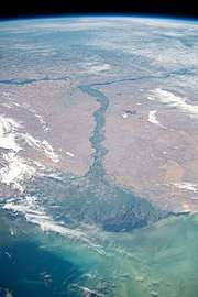
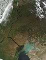
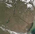
Satellite imagery
Cultural significance
Literature:
- "Without a Dowry", "The Storm" — dramas by the Russian playwright Aleksandr Ostrovsky
- "In the forests", "On the hills" — novels by Pavel Melnikov
- "Yegor Bulychov and Others", "Dostigayev and Others" — plays by Maxim Gorky
- "Distance After Distance" — poem by Aleksandr Tvardovsky
- "On the Volga" — a poem by Nikolay Nekrasov
- "Volga and Vazuza" — a poem by Samuil Marshak
- "The Precipice" — a novel by Ivan Goncharov
Cinema:
- "Volga-Volga" (1938) — a Soviet film comedy directed by Grigori Aleksandrov
- "Ekaterina Voronina" (1957) — Soviet drama film directed by Isidor Annensky
- "The Bridge Is Built" (1965) — a Soviet film about the construction of a road bridge across the Volga in Saratov by Oleg Efremov and Gavriil Egiazarov
- "A Cruel Romance" (1984) — romantic drama directed by Eldar Ryazanov
- "Election Day" (2007) — Russian comedy film directed by Oleg Fomin
- "Volga" (2016) — documentary directed by Andrey Aleshin
See also
References
- Scheffel, Richard L.; Wernet, Susan J., eds. (1980). Natural Wonders of the World. United States of America: Reader's Digest Association, Inc. p. 406. ISBN 0-89577-087-3.
- Volga at GEOnet Names Server
- «Река Волга» Archived 2016-03-05 at the Wayback Machine, Russian State Water Registry
- "Volga River Basin". ResearchGate. Retrieved 2019-09-11.
- Luttwak, Edward N. (2011). Grand strategy of the byzantine empire. Belknap Harvard. p. 52. ISBN 978-0674062078. OCLC 733913679.
- Walker, Joel (2007). "Iran and Its Neighbors in Late Antiquity: Art of the Sasanian Empire (224–642 C.E.)". American Journal of Archaeology. 111 (4): 797. doi:10.3764/aja.111.4.795. ISSN 0002-9114.
- McNeese, Tim. (2005). The Volga river. Philadelphia: Chelsea House Publishers. pp. 14–16. ISBN 0791082474. OCLC 56535045.
- See Max Vasmer's dictionary under "Волга".
- J.P. Mallory & D.Q. Adams, Encyclopedia of Indo-European Culture, s.v. "dew" (London: Fitzroy Dearborn, 1997), 158-9.
- Michiel de Vaan, Etymological Dictionary of Latin and the Other Italian Languages, s.v. "rōs, rōris" (Leiden: Brill, 2008), 526-7.
- Nourai, Ali. 2013. An Etymological Dictionary of Persian, English and Other Indo-European Languages. Index of Words in Different Languages Vol. 1 Vol. 1. p.130.
- Lebedynsky, Iaroslav. Les Sarmates : Amazones et lanciers cuirassés entre Oural et Danube. Paris: Editions Errance, 2002.
- Akhmetyanov R. G. Brief Historical and etymological dictionary of the Tatar language. - Kazan: Tat. publishing house, 2001. p. 76. ISBN 5-298-01004-0 (In tatar: Әхмәтьянов Р. Г. Татар теленең кыскача тарихи-этимологик сүзлеге. — Казан: Тат. кит. нәшр., 2001. б. 76. )
- Katona, Cseste. "Co-operation between the Viking Rus' and the Turkic nomads of steppe in the ninth-eleventh century" (PDF). Archived (PDF) from the original on 2019-04-18. Retrieved 2019-07-04.
- "Marija Gimbutas. "A Survey Study of the Ancient Balts - Reviewed by Jonas Puzinas". www.lituanus.org. Archived from the original on 2019-08-04. Retrieved 2019-05-30.
- Zhirohov, Mikhail. (2019). The Khazars : a Judeo-Turkish Empire on the Steppes, 7th-11th Centuries AD. Nicolle, David., Hook, Christa. London: Bloomsbury Publishing Plc. p. 47. ISBN 9781472830104. OCLC 1076253515.
- "Early East Slavic Tribes in Russia". Study.com. Archived from the original on 2019-03-28. Retrieved 2018-12-16.
- "Weather Sredniy Buzhan | Forecast, Radar, Lightning & Satellite". Meteologix - bookmark this page. Archived from the original on 2018-12-16. Retrieved 2018-12-16.
- "VORGESCHICHE DER URALISCHEN SPRACHFAMILIE, GESCHICHTE DER KLEINEREN URALISCHEN SPRACHEN: CHRONOLOGIE" (PDF). Archived (PDF) from the original on 2019-05-30. Retrieved 2019-05-30.
- "The Volga". www.volgawriter.com. Archived from the original (Microsoft FrontPage 12.0) on 2010-06-20. Retrieved 2010-06-11.
- "In all, Soviet dams flooded 2,600 villages and 165 cities, almost 78,000 sq. km. – the area of Maryland, Delaware, Massachusetts, and New Jersey combined – including nearly 31,000 sq. km. of agricultural land and 31,000 sq. km. of forestland". Quoted from: Paul R. Josephson. Industrialized Nature: Brute Force Technology and the Transformation of the Natural World. Island Press, 2002. ISBN 1-55963-777-3. Page 31.
- Brian Pearce, Introduction Archived 2008-02-03 at the Wayback Machine to Fyodor Raskolnikov s "Tales of Sub-lieutenant Ilyin."
- "::The Battle of Stalingrad". Historylearningsite.co.uk. Archived from the original on 2015-05-30. Retrieved 2010-06-11.
- "Early East Slavic Tribes in Russia | Study.com". Study.com. Archived from the original on 2018-08-26. Retrieved 2018-10-13.
- Mikhail., Zhirohov (2019). The Khazars : a Judeo-Turkish Empire on the Steppes, 7th-11th Centuries AD. Nicolle, David., Hook, Christa. London: Bloomsbury Publishing Plc. p. 47. ISBN 9781472830104. OCLC 1076253515.
- Bašić, Marko (2015-05-14). "Noble Sarmatian Grave Discovered In Russia". Slavorum. Archived from the original on 2019-03-28. Retrieved 2019-03-28.
- Tim., McNeese (2005). The Volga river. Philadelphia: Chelsea House Publishers. p. 14. ISBN 0791082474. OCLC 56535045.
- "When the Arabs met the Vikings: New discovery suggests ancient links". The National. Archived from the original on 2019-05-25. Retrieved 2019-05-25.
- "The Volga Trade Route". www.pbs.org. Archived from the original on 2019-05-23. Retrieved 2019-05-25.
- "Unique History of Volga River That You Need to Know - Learn Russian Language". Learn Russian Language. 2018-06-30. Archived from the original on 2018-10-13. Retrieved 2018-10-13.
- Korotenko, K. A.; Mamedov, R. M.; Mooers, C. N. K. (2000). "Prediction of the Dispersal of Oil Transport in the Caspian Sea Resulting from a Continuous Release". Spill Science & Technology Bulletin. 6 (5–6): 323. doi:10.1016/S1353-2561(01)00050-0.
- "NoorderSoft Waterways Database". Noordersoft.com. Archived from the original on November 9, 2005. Retrieved 2010-06-11.
External links
| Wikimedia Commons has media related to Volga. |
| Wikisource has the text of the 1911 Encyclopædia Britannica article Volga. |
- Volga Delta from Space
- Photos of the Volga coasts

- Video about the source of the Volga
The river Volga | ||
|---|---|---|
| Tributaries |
| |
| Reservoirs | ||
| Hydroelectric stations | ||
| Canals | ||
| Cities | ||
| Authority control |
|
|---|