Bloomington West Side Historic District
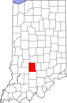
Bloomington West Side Historic District is a national historic district located at Bloomington, Monroe County, Indiana. The district encompasses 394 contributing buildings, 2 contributing sites, and 2 contributing structures in a mixed residential, commercial, and industrial section of Bloomington. It developed between about 1850 and 1946, and includes notable examples of Queen Anne and Bungalow/American Craftsman style architecture. Located in the district are the separately listed Elias Abel House, Cantol Wax Company Building, Coca-Cola Bottling Plant, Cochran-Helton-Lindley House, Illinois Central Railroad Freight Depot, Johnson's Creamery, and Second Baptist Church. Other notable contributing resources include the Works Progress Administration constructed wading pool, White Oak Cemetery, Ninth Street Park, Bloomington Wholesale Foods Warehouse (c. 1920), Bloomington Garage, Curry Buick, Banneker School, Bethel African Methodist Episcopal Church, and Bloomington Frosted Foods.[2]
Bloomington West Side Historic District | |
 Fourth Street in Bloomington's West Side, January 2011 | |
  | |
| Location | Roughly bounded by W. 10th, N. Morton, W. 4th, and N. Adams Sts., Bloomington, Indiana |
|---|---|
| Coordinates | 39°10′07″N 86°32′24″W |
| Area | 180 acres (73 ha) |
| Architect | Nichols, John; Plato, Samuel |
| Architectural style | Queen Anne, Bungalow/craftsman, gabled end |
| NRHP reference No. | 97000055[1] |
| Added to NRHP | February 14, 1997 |
It was listed on the National Register of Historic Places in 1997.[1]
References
| Wikimedia Commons has media related to Bloomington West Side Historic District. |
- "National Register Information System". National Register of Historic Places. National Park Service. July 9, 2010.
- "Indiana State Historic Architectural and Archaeological Research Database (SHAARD)" (Searchable database). Department of Natural Resources, Division of Historic Preservation and Archaeology. Retrieved 2016-05-01. Note: This includes Cynthia Brubaker and Nancy Heistand (February 1996). "National Register of Historic Places Inventory Nomination Form: Bloomington West Side Historic District" (PDF). Retrieved 2016-05-01., Site map, and Accompanying photographs.