Flastroff
| Flastroff | ||
|---|---|---|
| Commune | ||
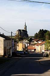 The Rue Saint-Éloi in Flastroff | ||
| ||
 Flastroff Location within Grand Est region  Flastroff | ||
| Coordinates: 49°22′03″N 6°32′01″E / 49.3675°N 6.5336°ECoordinates: 49°22′03″N 6°32′01″E / 49.3675°N 6.5336°E | ||
| Country | France | |
| Region | Grand Est | |
| Department | Moselle | |
| Arrondissement | Thionville | |
| Canton | Bouzonville | |
| Intercommunality | Communauté de communes des Trois Frontières | |
| Government | ||
| • Mayor (2008–2014) | Christian Kuhn | |
| Area1 | 8.38 km2 (3.24 sq mi) | |
| Population (1999)2 | 330 | |
| • Density | 39/km2 (100/sq mi) | |
| Time zone | UTC+1 (CET) | |
| • Summer (DST) | UTC+2 (CEST) | |
| INSEE/Postal code | 57215 /57320 | |
| Elevation |
214–307 m (702–1,007 ft) (avg. 220 m or 720 ft) | |
|
1 French Land Register data, which excludes lakes, ponds, glaciers > 1 km2 (0.386 sq mi or 247 acres) and river estuaries. 2 Population without double counting: residents of multiple communes (e.g., students and military personnel) only counted once. | ||
.svg.png)
Flastroff (German: Flasdorf; Lorraine Franconian: Flooschtroff) is a commune in the Moselle department in Grand Est in north-eastern France.
Localities of the commune: Zeurange (German: Zeringen).
See also
| Wikimedia Commons has media related to Flastroff. |
This article is issued from
Wikipedia.
The text is licensed under Creative Commons - Attribution - Sharealike.
Additional terms may apply for the media files.