Hagondange
| Hagondange | ||
|---|---|---|
| Commune | ||
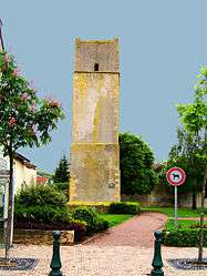 The 12th century tower in Hagondange | ||
| ||
 Hagondange Location within Grand Est region  Hagondange | ||
| Coordinates: 49°15′18″N 6°10′07″E / 49.255°N 6.1686°ECoordinates: 49°15′18″N 6°10′07″E / 49.255°N 6.1686°E | ||
| Country | France | |
| Region | Grand Est | |
| Department | Moselle | |
| Arrondissement | Metz | |
| Canton | Le Sillon Mosellan | |
| Intercommunality | Communauté de communes du Sillon mosellan | |
| Government | ||
| • Mayor (2008–2014) | Jean-Claude Mahler | |
| Area1 | 5.5 km2 (2.1 sq mi) | |
| Population (2008)2 | 9,053 | |
| • Density | 1,600/km2 (4,300/sq mi) | |
| Time zone | UTC+1 (CET) | |
| • Summer (DST) | UTC+2 (CEST) | |
| INSEE/Postal code | 57283 /57300 | |
| Elevation | 154–209 m (505–686 ft) | |
|
1 French Land Register data, which excludes lakes, ponds, glaciers > 1 km2 (0.386 sq mi or 247 acres) and river estuaries. 2 Population without double counting: residents of multiple communes (e.g., students and military personnel) only counted once. | ||
.svg.png)
Hagondange (German: Hagendingen, Lorraine Franconian: Hoendéngen/Hoendéng) is a commune in the Moselle department in Grand Est in north-eastern France.
It is located 20 km (12 mi) north of Metz and 20 km (12 mi) south of Thionville.
La Tour de Guet, a tower from the twelfth century, is found within the commune.
Notable people
- Eduard Isken (1918–1997) was a Luftwaffe fighter pilot and flying ace during World War II.
See also
| Wikimedia Commons has media related to Hagondange. |
| Authority control |
|---|
This article is issued from
Wikipedia.
The text is licensed under Creative Commons - Attribution - Sharealike.
Additional terms may apply for the media files.