Angevillers
| Angevillers | ||
|---|---|---|
| Commune | ||
 The church in Angevillers | ||
| ||
 Angevillers Location within Grand Est region  Angevillers | ||
| Coordinates: 49°23′19″N 6°02′36″E / 49.3886°N 6.0433°ECoordinates: 49°23′19″N 6°02′36″E / 49.3886°N 6.0433°E | ||
| Country | France | |
| Region | Grand Est | |
| Department | Moselle | |
| Arrondissement | Thionville | |
| Canton | Algrange | |
| Intercommunality | Portes de France-Thionville | |
| Government | ||
| • Mayor (2014-2020) | Marcelle Brier | |
| Area1 | 8.71 km2 (3.36 sq mi) | |
| Population (2014)2 | 1,246 | |
| • Density | 140/km2 (370/sq mi) | |
| Time zone | UTC+1 (CET) | |
| • Summer (DST) | UTC+2 (CEST) | |
| INSEE/Postal code | 57022 /57440 | |
| Elevation |
315–418 m (1,033–1,371 ft) (avg. 363 m or 1,191 ft) | |
|
1 French Land Register data, which excludes lakes, ponds, glaciers > 1 km2 (0.386 sq mi or 247 acres) and river estuaries. 2 Population without double counting: residents of multiple communes (e.g., students and military personnel) only counted once. | ||

Angevillers (Lorraine Franconian Aasler, German: Arsweiler) is a commune in the Moselle department in Grand Est in northeastern France.
Population
| Historical population | ||
|---|---|---|
| Year | Pop. | ±% |
| 1962 | 1,196 | — |
| 1968 | 1,397 | +16.8% |
| 1975 | 1,441 | +3.1% |
| 1982 | 1,284 | −10.9% |
| 1990 | 1,175 | −8.5% |
| 1999 | 1,185 | +0.9% |
| 2006 | 1,262 | +6.5% |
| 2009 | 1,281 | +1.5% |
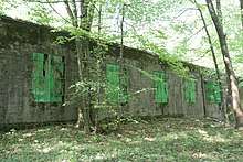
Former Hitler's HQ in the nearby forest
See also
- Communes of the Moselle department
- Ouvrage Rochonvillers, a Maginot Line fortification
References
| Wikimedia Commons has media related to Angevillers. |
| Authority control |
|---|
This article is issued from
Wikipedia.
The text is licensed under Creative Commons - Attribution - Sharealike.
Additional terms may apply for the media files.