Reyersviller
| Reyersviller | ||
|---|---|---|
| Commune | ||
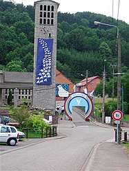 The church in Reyersviller | ||
| ||
 Reyersviller Location within Grand Est region  Reyersviller | ||
| Coordinates: 49°02′32″N 7°23′44″E / 49.0422°N 7.3956°ECoordinates: 49°02′32″N 7°23′44″E / 49.0422°N 7.3956°E | ||
| Country | France | |
| Region | Grand Est | |
| Department | Moselle | |
| Arrondissement | Sarreguemines | |
| Canton | Bitche | |
| Intercommunality | CC du Pays de Bitche | |
| Government | ||
| • Mayor (2008–2014) | Édouard Schaming | |
| Area1 | 8.32 km2 (3.21 sq mi) | |
| Population (1999)2 | 360 | |
| • Density | 43/km2 (110/sq mi) | |
| Time zone | UTC+1 (CET) | |
| • Summer (DST) | UTC+2 (CEST) | |
| INSEE/Postal code | 57577 /57230 | |
| Elevation |
266–428 m (873–1,404 ft) (avg. 274 m or 899 ft) | |
|
1 French Land Register data, which excludes lakes, ponds, glaciers > 1 km2 (0.386 sq mi or 247 acres) and river estuaries. 2 Population without double counting: residents of multiple communes (e.g., students and military personnel) only counted once. | ||

Reyersviller (German: Reyersweiler, Lorraine Franconian: Reierschwiller) is a commune in the Moselle department of the Grand Est administrative region in north-eastern France.
The village belongs to the Pays de Bitche and to the Northern Vosges Regional Nature Park.
See also
| Wikimedia Commons has media related to Reyersviller. |
This article is issued from
Wikipedia.
The text is licensed under Creative Commons - Attribution - Sharealike.
Additional terms may apply for the media files.