Sarreinsming
| Sarreinsming | ||
|---|---|---|
| Commune | ||
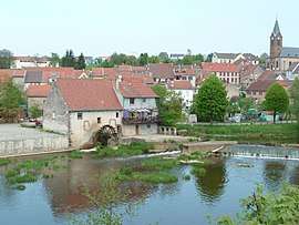 The mill in Sarreinsming | ||
| ||
 Sarreinsming Location within Grand Est region  Sarreinsming | ||
| Coordinates: 49°05′23″N 7°06′34″E / 49.0897°N 7.1094°ECoordinates: 49°05′23″N 7°06′34″E / 49.0897°N 7.1094°E | ||
| Country | France | |
| Region | Grand Est | |
| Department | Moselle | |
| Arrondissement | Sarreguemines | |
| Canton | Sarreguemines | |
| Intercommunality | Communauté d'agglomération Sarreguemines Confluences | |
| Government | ||
| • Mayor (2008–2014) | Pierre Schaub | |
| Area1 | 6.98 km2 (2.69 sq mi) | |
| Population (2010)2 | 1,294 | |
| • Density | 190/km2 (480/sq mi) | |
| Time zone | UTC+1 (CET) | |
| • Summer (DST) | UTC+2 (CEST) | |
| INSEE/Postal code | 57633 /57905 | |
| Elevation | 194–310 m (636–1,017 ft) | |
|
1 French Land Register data, which excludes lakes, ponds, glaciers > 1 km2 (0.386 sq mi or 247 acres) and river estuaries. 2 Population without double counting: residents of multiple communes (e.g., students and military personnel) only counted once. | ||

Sarreinsming (German: Saareinsmingen, Lorraine Franconian: Äänsminge) is a commune in the Moselle department in Grand Est in north-eastern France.
See also
| Wikimedia Commons has media related to Sarreinsming. |
This article is issued from
Wikipedia.
The text is licensed under Creative Commons - Attribution - Sharealike.
Additional terms may apply for the media files.