Etting
| Etting | ||
|---|---|---|
| Commune | ||
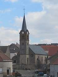 The church in Etting | ||
| ||
 Etting Location within Grand Est region  Etting | ||
| Coordinates: 49°01′52″N 7°10′48″E / 49.0311°N 7.18°ECoordinates: 49°01′52″N 7°10′48″E / 49.0311°N 7.18°E | ||
| Country | France | |
| Region | Grand Est | |
| Department | Moselle | |
| Arrondissement | Sarreguemines | |
| Canton | Bitche | |
| Intercommunality | CC du Pays de Bitche | |
| Government | ||
| • Mayor (2008–2014) | Hubert Hoffmann | |
| Area1 | 7.06 km2 (2.73 sq mi) | |
| Population (1999)2 | 778 | |
| • Density | 110/km2 (290/sq mi) | |
| Time zone | UTC+1 (CET) | |
| • Summer (DST) | UTC+2 (CEST) | |
| INSEE/Postal code | 57201 /57412 | |
| Elevation |
233–357 m (764–1,171 ft) (avg. 309 m or 1,014 ft) | |
|
1 French Land Register data, which excludes lakes, ponds, glaciers > 1 km2 (0.386 sq mi or 247 acres) and river estuaries. 2 Population without double counting: residents of multiple communes (e.g., students and military personnel) only counted once. | ||
.svg.png)
Etting (German: Ettingen, Lorraine Franconian: Ettinge) is a commune in the Moselle department of the Grand Est administrative region in north-eastern France.
The village belongs to the Pays de Bitche.
See also
| Wikimedia Commons has media related to Etting. |
This article is issued from
Wikipedia.
The text is licensed under Creative Commons - Attribution - Sharealike.
Additional terms may apply for the media files.