Cutting, Moselle
| Cutting | ||
|---|---|---|
| Commune | ||
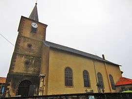 The church in Cutting | ||
| ||
 Cutting Location within Grand Est region  Cutting | ||
| Coordinates: 48°50′58″N 6°50′07″E / 48.8494°N 6.8353°ECoordinates: 48°50′58″N 6°50′07″E / 48.8494°N 6.8353°E | ||
| Country | France | |
| Region | Grand Est | |
| Department | Moselle | |
| Arrondissement | Sarrebourg-Château-Salins | |
| Canton | Le Saulnois | |
| Intercommunality | Communauté de communes du Saulnois | |
| Government | ||
| • Mayor (2008–2014) | Charles Trompette | |
| Area1 | 5.62 km2 (2.17 sq mi) | |
| Population (1999)2 | 147 | |
| • Density | 26/km2 (68/sq mi) | |
| Time zone | UTC+1 (CET) | |
| • Summer (DST) | UTC+2 (CEST) | |
| INSEE/Postal code | 57161 /57260 | |
| Elevation |
213–256 m (699–840 ft) (avg. 253 m or 830 ft) | |
|
1 French Land Register data, which excludes lakes, ponds, glaciers > 1 km2 (0.386 sq mi or 247 acres) and river estuaries. 2 Population without double counting: residents of multiple communes (e.g., students and military personnel) only counted once. | ||
.svg.png)
Cutting (German: Kuttingen) is a commune in the Moselle department in Grand Est in north-eastern France.
History
Previous names:[1] Kuctinga (1328), Kuttanges (1476), Kuttingen (1525), Kuchtingen (1575), Kutingen (1600), Kittingen (1665), Kutting (1801).
See also
References
| Wikimedia Commons has media related to Cutting (Moselle). |
- ↑ Dictionnaire topographique du département de la Meurthe - Henri Lepage
This article is issued from
Wikipedia.
The text is licensed under Creative Commons - Attribution - Sharealike.
Additional terms may apply for the media files.