Rettel
| Rettel | ||
|---|---|---|
| Commune | ||
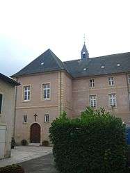 The abbey in Rettel | ||
| ||
 Rettel Location within Grand Est region  Rettel | ||
| Coordinates: 49°26′37″N 6°19′43″E / 49.4436°N 6.3286°ECoordinates: 49°26′37″N 6°19′43″E / 49.4436°N 6.3286°E | ||
| Country | France | |
| Region | Grand Est | |
| Department | Moselle | |
| Arrondissement | Thionville | |
| Canton | Bouzonville | |
| Intercommunality | Communauté de communes des Trois Frontières | |
| Government | ||
| • Mayor (2008–2014) | Jean Schwenck | |
| Area1 | 6.89 km2 (2.66 sq mi) | |
| Population (1999)2 | 684 | |
| • Density | 99/km2 (260/sq mi) | |
| Time zone | UTC+1 (CET) | |
| • Summer (DST) | UTC+2 (CEST) | |
| INSEE/Postal code | 57576 /57480 | |
| Elevation |
145–300 m (476–984 ft) (avg. 150 m or 490 ft) | |
|
1 French Land Register data, which excludes lakes, ponds, glaciers > 1 km2 (0.386 sq mi or 247 acres) and river estuaries. 2 Population without double counting: residents of multiple communes (e.g., students and military personnel) only counted once. | ||
.svg.png)
Rettel is a commune in the Moselle department in Grand Est in north-eastern France.
See also
| Wikimedia Commons has media related to Rettel. |
This article is issued from
Wikipedia.
The text is licensed under Creative Commons - Attribution - Sharealike.
Additional terms may apply for the media files.