Epping, Moselle
| Epping | ||
|---|---|---|
| Commune | ||
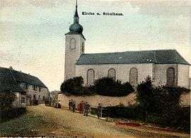 The church and school in Epping in 1909 | ||
| ||
 Epping Location within Grand Est region  Epping | ||
| Coordinates: 49°06′46″N 7°19′04″E / 49.1128°N 7.3178°ECoordinates: 49°06′46″N 7°19′04″E / 49.1128°N 7.3178°E | ||
| Country | France | |
| Region | Grand Est | |
| Department | Moselle | |
| Arrondissement | Sarreguemines | |
| Canton | Bitche | |
| Intercommunality | CC du Pays de Bitche | |
| Government | ||
| • Mayor (2008–2014) | Jean-Louis Chudz | |
| Area1 | 10.65 km2 (4.11 sq mi) | |
| Population (1999)2 | 511 | |
| • Density | 48/km2 (120/sq mi) | |
| Time zone | UTC+1 (CET) | |
| • Summer (DST) | UTC+2 (CEST) | |
| INSEE/Postal code | 57195 /57720 | |
| Elevation |
252–378 m (827–1,240 ft) (avg. 280 m or 920 ft) | |
|
1 French Land Register data, which excludes lakes, ponds, glaciers > 1 km2 (0.386 sq mi or 247 acres) and river estuaries. 2 Population without double counting: residents of multiple communes (e.g., students and military personnel) only counted once. | ||
.svg.png)
Epping (German: Eppingen, Lorraine Franconian: Eppinge) is a commune in the Moselle department of the Grand Est administrative region in north-eastern France.
The village belongs to the Pays de Bitche and to the Northern Vosges Regional Nature Park.
See also
| Wikimedia Commons has media related to Epping, Moselle. |
This article is issued from
Wikipedia.
The text is licensed under Creative Commons - Attribution - Sharealike.
Additional terms may apply for the media files.