Montigny-lès-Metz
| Montigny-lès-Metz | ||
|---|---|---|
| Commune | ||
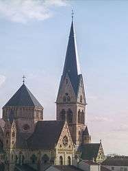 The church in Montigny-lès-Metz | ||
| ||
 Montigny-lès-Metz Location within Grand Est region  Montigny-lès-Metz | ||
| Coordinates: 49°06′02″N 6°09′14″E / 49.1006°N 6.1539°ECoordinates: 49°06′02″N 6°09′14″E / 49.1006°N 6.1539°E | ||
| Country | France | |
| Region | Grand Est | |
| Department | Moselle | |
| Arrondissement | Metz | |
| Canton | Montigny-lès-Metz | |
| Intercommunality | Metz Métropole | |
| Government | ||
| • Mayor (2008–2014) | Jean-Luc Bohl (NC) | |
| Area1 | 6.70 km2 (2.59 sq mi) | |
| Population (1999)2 | 23,437 | |
| • Density | 3,500/km2 (9,100/sq mi) | |
| Time zone | UTC+1 (CET) | |
| • Summer (DST) | UTC+2 (CEST) | |
| INSEE/Postal code | 57480 /57950 | |
| Elevation | 165–190 m (541–623 ft) | |
|
1 French Land Register data, which excludes lakes, ponds, glaciers > 1 km2 (0.386 sq mi or 247 acres) and river estuaries. 2 Population without double counting: residents of multiple communes (e.g., students and military personnel) only counted once. | ||
.svg.png)
Montigny-lès-Metz (German: Monteningen) is a commune in the Moselle department in Grand Est in north-eastern France.
It is the largest suburb of the city of Metz, and is adjacent to it on the west.
Points of interest
See also
External links
| Wikimedia Commons has media related to Montigny-lès-Metz. |
- Official website (in French)
This article is issued from
Wikipedia.
The text is licensed under Creative Commons - Attribution - Sharealike.
Additional terms may apply for the media files.