Azoudange
| Azoudange | ||
|---|---|---|
| Commune | ||
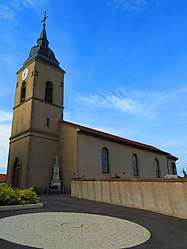 The church in Azoudange | ||
| ||
 Azoudange Location within Grand Est region  Azoudange | ||
| Coordinates: 48°44′24″N 6°48′46″E / 48.74°N 6.8128°ECoordinates: 48°44′24″N 6°48′46″E / 48.74°N 6.8128°E | ||
| Country | France | |
| Region | Grand Est | |
| Department | Moselle | |
| Arrondissement | Sarrebourg-Château-Salins | |
| Canton | Sarrebourg | |
| Intercommunality | CC Sarrebourg - Moselle Sud | |
| Government | ||
| • Mayor (2014-2020) | Francine Bagard | |
| Area1 | 15.73 km2 (6.07 sq mi) | |
| Population (2014)2 | 114 | |
| • Density | 7.2/km2 (19/sq mi) | |
| Time zone | UTC+1 (CET) | |
| • Summer (DST) | UTC+2 (CEST) | |
| INSEE/Postal code | 57044 /57810 | |
| Elevation |
217–302 m (712–991 ft) (avg. 243 m or 797 ft) | |
|
1 French Land Register data, which excludes lakes, ponds, glaciers > 1 km2 (0.386 sq mi or 247 acres) and river estuaries. 2 Population without double counting: residents of multiple communes (e.g., students and military personnel) only counted once. | ||

Azoudange (German: Anslingen) is a commune in the Moselle department in Grand Est in northeastern France.
Population
| Historical population | ||
|---|---|---|
| Year | Pop. | ±% |
| 1962 | 161 | — |
| 1968 | 182 | +13.0% |
| 1975 | 154 | −15.4% |
| 1982 | 123 | −20.1% |
| 1990 | 103 | −16.3% |
| 1999 | 106 | +2.9% |
| 2006 | 113 | +6.6% |
| 2009 | 113 | +0.0% |
| 2014 | 114 | +0.9% |
See also
References
| Wikimedia Commons has media related to Azoudange. |
This article is issued from
Wikipedia.
The text is licensed under Creative Commons - Attribution - Sharealike.
Additional terms may apply for the media files.