Ottange
| Ottange | ||
|---|---|---|
| Commune | ||
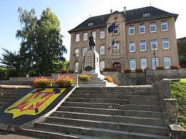 The town hall in Ottange | ||
| ||
 Ottange Location within Grand Est region  Ottange | ||
| Coordinates: 49°26′35″N 6°01′09″E / 49.4431°N 6.0192°ECoordinates: 49°26′35″N 6°01′09″E / 49.4431°N 6.0192°E | ||
| Country | France | |
| Region | Grand Est | |
| Department | Moselle | |
| Arrondissement | Thionville | |
| Canton | Algrange | |
| Intercommunality | Communauté de communes du Pays-Haut Val d'Alzette | |
| Government | ||
| • Mayor (2008–2014) | Georges Oblet | |
| Area1 | 15.48 km2 (5.98 sq mi) | |
| Population (2015)2 | 2,992 | |
| • Density | 190/km2 (500/sq mi) | |
| Time zone | UTC+1 (CET) | |
| • Summer (DST) | UTC+2 (CEST) | |
| INSEE/Postal code | 57529 /57840 | |
| Elevation |
295–428 m (968–1,404 ft) (avg. 315 m or 1,033 ft) | |
|
1 French Land Register data, which excludes lakes, ponds, glaciers > 1 km2 (0.386 sq mi or 247 acres) and river estuaries. 2 Population without double counting: residents of multiple communes (e.g., students and military personnel) only counted once. | ||

Ottange (German: Öttingen, Lorraine Franconian: Ëtténg/Otténg) is a commune in the Moselle department in Grand Est in north-eastern France.
See also
| Wikimedia Commons has media related to Ottange. |
This article is issued from
Wikipedia.
The text is licensed under Creative Commons - Attribution - Sharealike.
Additional terms may apply for the media files.