Hettange-Grande
| Hettange-Grande | ||
|---|---|---|
| Commune | ||
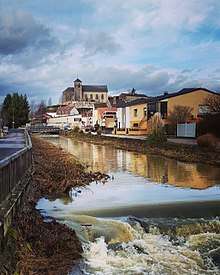 The Church of Hettnage-Grande, located on the hill "Le Rocher" in the town center from the river "La Kissel" | ||
| ||
 Hettange-Grande Location within Grand Est region  Hettange-Grande | ||
| Coordinates: 49°24′24″N 6°09′14″E / 49.4067°N 6.1539°ECoordinates: 49°24′24″N 6°09′14″E / 49.4067°N 6.1539°E | ||
| Country | France | |
| Region | Grand Est | |
| Department | Moselle | |
| Arrondissement | Thionville | |
| Canton | Yutz | |
| Government | ||
| • Mayor (2008-2014) | André Hentz | |
| Area1 | 16.27 km2 (6.28 sq mi) | |
| Population (2009)2 | 7,814 | |
| • Density | 480/km2 (1,200/sq mi) | |
| Time zone | UTC+1 (CET) | |
| • Summer (DST) | UTC+2 (CEST) | |
| INSEE/Postal code | 57323 /57330 | |
| Elevation | 155–247 m (509–810 ft) | |
|
1 French Land Register data, which excludes lakes, ponds, glaciers > 1 km2 (0.386 sq mi or 247 acres) and river estuaries. 2 Population without double counting: residents of multiple communes (e.g., students and military personnel) only counted once. | ||

Hettange-Grande (German: Großhettingen, Lorraine Franconian: Grouss-Hetténgen) is a commune in the Moselle department in Grand Est in north-eastern France.
The town gave its name to the Hettangian, the earliest age of the Jurassic period of the geologic timescale.
Geography
Hettange-Grande is located close to the borders between France, Germany, and Luxembourg.
History
Hettange-Grande was part of the Duchy of Luxembourg until the 1659 Treaty of the Pyrenees, when it was ceded to France during the first Partition of Luxembourg, along with the nearby town of Thionville.
Transportation
The commune is located on the N53 highway, which runs from Thionville north to Luxembourg.

Twin towns
Hettange-Grande is twinned with:
See also
| Wikimedia Commons has media related to Hettange-Grande. |