Haute-Kontz
| Haute-Kontz | ||
|---|---|---|
| Commune | ||
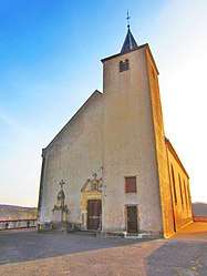 The church in Haute-Kontz | ||
| ||
 Haute-Kontz Location within Grand Est region  Haute-Kontz | ||
| Coordinates: 49°27′12″N 6°19′07″E / 49.4533°N 6.3186°ECoordinates: 49°27′12″N 6°19′07″E / 49.4533°N 6.3186°E | ||
| Country | France | |
| Region | Grand Est | |
| Department | Moselle | |
| Arrondissement | Thionville | |
| Canton | Bouzonville | |
| Intercommunality | Communauté de communes des Trois Frontières | |
| Government | ||
| • Mayor (2008–2014) | Marie-Josée Thill | |
| Area1 | 6.41 km2 (2.47 sq mi) | |
| Population (1999)2 | 439 | |
| • Density | 68/km2 (180/sq mi) | |
| Time zone | UTC+1 (CET) | |
| • Summer (DST) | UTC+2 (CEST) | |
| INSEE/Postal code | 57371 /57480 | |
| Elevation |
145–286 m (476–938 ft) (avg. 195 m or 640 ft) | |
|
1 French Land Register data, which excludes lakes, ponds, glaciers > 1 km2 (0.386 sq mi or 247 acres) and river estuaries. 2 Population without double counting: residents of multiple communes (e.g., students and military personnel) only counted once. | ||

Haute-Kontz (German: Oberkontz, Lorraine Franconian: Uewer-Kontz/Uewer-Konz) is a commune in the Moselle department in Grand Est in north-eastern France.
The commune is located very close to the border with Luxembourg in the Pays de Sierck.
See also
| Wikimedia Commons has media related to Haute-Kontz. |
This article is issued from
Wikipedia.
The text is licensed under Creative Commons - Attribution - Sharealike.
Additional terms may apply for the media files.