Aulnois-sur-Seille
| Aulnois-sur-Seille | ||
|---|---|---|
| Commune | ||
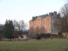 The chateau in Aulnois-sur-Seille | ||
| ||
 Aulnois-sur-Seille Location within Grand Est region  Aulnois-sur-Seille | ||
| Coordinates: 48°52′10″N 6°18′57″E / 48.8694°N 6.3158°ECoordinates: 48°52′10″N 6°18′57″E / 48.8694°N 6.3158°E | ||
| Country | France | |
| Region | Grand Est | |
| Department | Moselle | |
| Arrondissement | Sarrebourg-Château-Salins | |
| Canton | Le Saulnois | |
| Intercommunality | CC Saulnois | |
| Government | ||
| • Mayor (2014-2020) | Jean-Luc Provost | |
| Area1 | 5.09 km2 (1.97 sq mi) | |
| Population (2015)2 | 274 | |
| • Density | 54/km2 (140/sq mi) | |
| Time zone | UTC+1 (CET) | |
| • Summer (DST) | UTC+2 (CEST) | |
| INSEE/Postal code | 57040 /57590 | |
| Elevation |
187–272 m (614–892 ft) (avg. 180 m or 590 ft) | |
|
1 French Land Register data, which excludes lakes, ponds, glaciers > 1 km2 (0.386 sq mi or 247 acres) and river estuaries. 2 Population without double counting: residents of multiple communes (e.g., students and military personnel) only counted once. | ||

Aulnois-sur-Seille (German: Erlen) is a commune in the Moselle department in Grand Est in northeastern France.
Population
| Historical population | ||
|---|---|---|
| Year | Pop. | ±% |
| 1962 | 221 | — |
| 1968 | 235 | +6.3% |
| 1975 | 213 | −9.4% |
| 1982 | 205 | −3.8% |
| 1990 | 214 | +4.4% |
| 1999 | 249 | +16.4% |
| 2007 | 250 | +0.4% |
| 2009 | 239 | −4.4% |
| 2015 | 274 | +14.6% |
See also
References
| Wikimedia Commons has media related to Aulnois-sur-Seille. |
This article is issued from
Wikipedia.
The text is licensed under Creative Commons - Attribution - Sharealike.
Additional terms may apply for the media files.