Éblange
| Éblange | ||
|---|---|---|
| Commune | ||
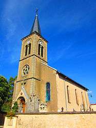 St. Wendelin's Church | ||
| ||
 Éblange Location within Grand Est region  Éblange | ||
| Coordinates: 49°13′27″N 6°28′58″E / 49.2242°N 6.4828°ECoordinates: 49°13′27″N 6°28′58″E / 49.2242°N 6.4828°E | ||
| Country | France | |
| Region | Grand Est | |
| Department | Moselle | |
| Arrondissement | Forbach-Boulay-Moselle | |
| Canton | Boulay-Moselle | |
| Intercommunality | Communauté de communes du Pays boulageois | |
| Government | ||
| • Mayor (2008–2014) | Alphonse Bastian | |
| Area1 | 3.32 km2 (1.28 sq mi) | |
| Population 2 | 375 | |
| • Density | 110/km2 (290/sq mi) | |
| Time zone | UTC+1 (CET) | |
| • Summer (DST) | UTC+2 (CEST) | |
| INSEE/Postal code | 57187 /57220 | |
| Elevation |
198–295 m (650–968 ft) (avg. 202 m or 663 ft) | |
|
1 French Land Register data, which excludes lakes, ponds, glaciers > 1 km2 (0.386 sq mi or 247 acres) and river estuaries. 2 Population without double counting: residents of multiple communes (e.g., students and military personnel) only counted once. | ||
.svg.png)
Éblange (German: Eblingen) is a commune in the Moselle department in Grand Est in north-eastern France.[1]
See also
| Wikimedia Commons has media related to Éblange. |
References
This article is issued from
Wikipedia.
The text is licensed under Creative Commons - Attribution - Sharealike.
Additional terms may apply for the media files.