Sainte-Ruffine
| Sainte-Ruffine | ||
|---|---|---|
| Commune | ||
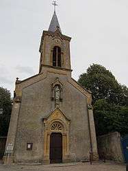 The church in Sainte-Ruffine | ||
| ||
 Sainte-Ruffine Location within Grand Est region  Sainte-Ruffine | ||
| Coordinates: 49°06′21″N 6°05′47″E / 49.1058°N 6.0964°ECoordinates: 49°06′21″N 6°05′47″E / 49.1058°N 6.0964°E | ||
| Country | France | |
| Region | Grand Est | |
| Department | Moselle | |
| Arrondissement | Metz | |
| Canton | Les Coteaux de Moselle | |
| Intercommunality | Metz Métropole | |
| Government | ||
| • Mayor (2008–2014) | Jean-Claude Wannenmacher | |
| Area1 | 0.7 km2 (0.3 sq mi) | |
| Population (1999)2 | 453 | |
| • Density | 650/km2 (1,700/sq mi) | |
| Time zone | UTC+1 (CET) | |
| • Summer (DST) | UTC+2 (CEST) | |
| INSEE/Postal code | 57624 /57130 | |
| Elevation |
166–226 m (545–741 ft) (avg. 230 m or 750 ft) | |
|
1 French Land Register data, which excludes lakes, ponds, glaciers > 1 km2 (0.386 sq mi or 247 acres) and river estuaries. 2 Population without double counting: residents of multiple communes (e.g., students and military personnel) only counted once. | ||

Sainte-Ruffine (German: Sankt Ruffin) is a commune in the Moselle department in Grand Est in north-eastern France.
See also
References
| Wikimedia Commons has media related to Sainte-Ruffine. |
This article is issued from
Wikipedia.
The text is licensed under Creative Commons - Attribution - Sharealike.
Additional terms may apply for the media files.