Vibersviller
| Vibersviller | ||
|---|---|---|
| Commune | ||
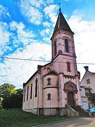 The Lutheran church in Vibersviller | ||
| ||
 Vibersviller Location within Grand Est region  Vibersviller | ||
| Coordinates: 48°54′54″N 6°56′42″E / 48.915°N 6.945°ECoordinates: 48°54′54″N 6°56′42″E / 48.915°N 6.945°E | ||
| Country | France | |
| Region | Grand Est | |
| Department | Moselle | |
| Arrondissement | Sarrebourg-Château-Salins | |
| Canton | Le Saulnois | |
| Intercommunality | Communauté de communes du Saulnois | |
| Government | ||
| • Mayor (2008–2014) | Roland Weiss | |
| Area1 | 13.02 km2 (5.03 sq mi) | |
| Population (1999)2 | 405 | |
| • Density | 31/km2 (81/sq mi) | |
| Time zone | UTC+1 (CET) | |
| • Summer (DST) | UTC+2 (CEST) | |
| INSEE/Postal code | 57711 /57670 | |
| Elevation |
216–266 m (709–873 ft) (avg. 322 m or 1,056 ft) | |
|
1 French Land Register data, which excludes lakes, ponds, glaciers > 1 km2 (0.386 sq mi or 247 acres) and river estuaries. 2 Population without double counting: residents of multiple communes (e.g., students and military personnel) only counted once. | ||
.svg.png)
Vibersviller (German: Wiebersweiler) is a commune in the Moselle department in Grand Est in north-eastern France.
See also
| Wikimedia Commons has media related to Vibersviller. |
This article is issued from
Wikipedia.
The text is licensed under Creative Commons - Attribution - Sharealike.
Additional terms may apply for the media files.