Warren, Rhode Island
| Warren, Rhode Island | |
|---|---|
| Town | |
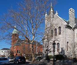 Main Street, Warren, Rhode Island, USA | |
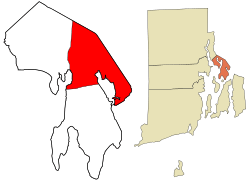 Location in Bristol County and the state of Rhode Island | |
| Coordinates: 41°43′34″N 71°16′14″W / 41.72611°N 71.27056°W | |
| Country | United States |
| State | Rhode Island |
| County | Bristol |
| Settled | 1680 |
| Incorporated | January 27, 1747 |
| Government | |
| • Type | Representative town meeting |
| • Town Counsel |
Joseph A. DePasquale (I) P. Brandt Heckert (D) David S. Frerichs (D) Steven R. Thompson (D) Scott F. Lial (I) |
| • Town Moderator | Pasquale T. Annarummo (D) |
| Area | |
| • Total | 8.7 sq mi (22.4 km2) |
| • Land | 6.2 sq mi (15.9 km2) |
| • Water | 2.5 sq mi (6.5 km2) |
| Elevation | 7 ft (2 m) |
| Population (2010) | |
| • Total | 10,611 |
| • Density | 1,729/sq mi (667.4/km2) |
| Time zone | UTC-5 (Eastern (EST)) |
| • Summer (DST) | UTC-4 (EDT) |
| ZIP code | 02885 |
| Area code(s) | 401 |
| FIPS code | 25-37175 |
| GNIS feature ID | 1220057[1] |
| Website | http://www.townofwarren-ri.gov/ |
Warren is a town in Bristol County, Rhode Island. The population was 10,611 at the 2010 census.
History
Warren was the site of the Indian village of Sowams, located on the peninsula called Pokanoket (Mount Hope Neck), and Edward Winslow and Stephen Hopkins from the Plymouth Colony established a trading post there in 1621. In 1623, Winslow and John Hampden saved the life of Wampanoag Sachem Massasoit, gaining an important ally. In 1636, Roger Williams was banished from Salem, Massachusetts and fled to Sowams, where he was sheltered by Massasoit until he established Providence Plantations.
Permanent English settlement began east of the Indian village starting in 1653. Massasoit and his oldest son sold to certain Plymouth Colony settlers what is now Warren and parts of Barrington, Rhode Island, Swansea, Massachusetts, and Rehoboth, Massachusetts. The land was part of the Massachusetts Bay Colony and was first incorporated as part of Swansea. After the death of Massasoit, however, relations became strained between the Indians and the settlers, leading to King Philip's War in 1675 when the Indians destroyed the settlement at Sowams. In 1668, the township was officially incorporated with the name Sowams; in 1691, the Plymouth Colony merged with the Massachusetts Bay Colony.
Sowams was ceded to Rhode Island from Massachusetts in 1747 along with the Attleborough Gore (now Cumberland), Barrington, Bristol, Tiverton, and Little Compton, Rhode Island.[2] The town was named "Warren" after British naval hero Admiral Sir Peter Warren after a victory at Louisburg in 1745. Barrington was unified with Warren at the time, until it was separated again in 1770.
Warren was the original home of Brown University, founded in 1764 as the College in the English Colony of Rhode Island and Providence Plantations. The school registered its first students in 1765 and was the Baptist answer to Congregationalist Yale and Harvard, Presbyterian Princeton, and Episcopalian Penn and Columbia. It was the only one of these schools that welcomed students of all religious persuasions, following the example of Roger Williams, who founded Rhode Island in 1636 on the same principle.
In the mid-18th century, the town was well known as a whaling port, and ship building became an important industry. The Revolutionary War seriously affected Warren's commercial prosperity, and the town suffered British raids in 1778 along with the rest of the region. Commerce revived within the decade after the Revolution until the middle of the 19th century, and Warren was famous for the fine vessels launched from its yards. These vessels were largely commanded and operated by Warren crews, and they engaged in whaling, merchant service, and the West India trade. Three notable ships were built in Warren by Chase & Davis: the 1853 clipper Lookout, the 1853 clipper bark Gem of the Sea, and the 1854 clipper bark Mary Ogden.
With the decline of the whaling industry and related seafaring commerce toward the middle of the 19th century, business attention turned to textile manufacturing. Warren's first cotton mill was erected by the Warren Manufacturing Company in 1847. Further mills and factories developed during and after the Civil War, attracting an immigrant work force. Today, Warren is home to several waterfront businesses such as Blount Marine, Blount Seafood, and Dyer Boats.
Geography
According to the United States Census Bureau, the town has a total area of 8.6 square miles (22 km2), of which 6.2 square miles (16 km2) is land and 2.5 square miles (6.5 km2) (28.90%) is water. Warren is located on the east bank of the Warren River (opposite Barrington, Rhode Island).
Demographics
| Historical population | |||
|---|---|---|---|
| Census | Pop. | %± | |
| 1790 | 1,122 | — | |
| 1800 | 1,473 | 31.3% | |
| 1810 | 1,775 | 20.5% | |
| 1820 | 1,806 | 1.7% | |
| 1830 | 1,800 | −0.3% | |
| 1840 | 2,437 | 35.4% | |
| 1850 | 3,103 | 27.3% | |
| 1860 | 2,636 | −15.0% | |
| 1870 | 3,008 | 14.1% | |
| 1880 | 4,007 | 33.2% | |
| 1890 | 4,489 | 12.0% | |
| 1900 | 5,108 | 13.8% | |
| 1910 | 6,585 | 28.9% | |
| 1920 | 7,841 | 19.1% | |
| 1930 | 7,974 | 1.7% | |
| 1940 | 8,158 | 2.3% | |
| 1950 | 8,513 | 4.4% | |
| 1960 | 8,750 | 2.8% | |
| 1970 | 10,523 | 20.3% | |
| 1980 | 10,640 | 1.1% | |
| 1990 | 11,385 | 7.0% | |
| 2000 | 11,360 | −0.2% | |
| 2010 | 10,611 | −6.6% | |
| Est. 2015 | 10,487 | [3] | −1.2% |
| U.S. Decennial Census[4][5] | |||
As of the census[6] of 2000, there were 11,360 people, 4,708 households, and 2,994 families residing in the town. The population density was 1,845.8 people per square mile (713.2/km²). There were 4,977 housing units at an average density of 808.7 per square mile (312.5/km²). The racial makeup of the town was 96.82% White, 0.83% African American, 0.23% Native American, 0.50% Asian, 0.04% Pacific Islander, 0.29% from other races, and 1.29% from two or more races. Hispanic or Latino of any race were 0.93% of the population.
There were 4,708 households out of which 27.4% had children under the age of 18 living with them, 47.3% were married couples living together, 12.6% had a female householder with no husband present, and 36.4% were non-families. 30.8% of all households were made up of individuals and 11.7% had someone living alone who was 65 years of age or older. The average household size was 2.36 and the average family size was 2.96.
In the town, the population was spread out with 21.6% under the age of 18, 7.6% from 18 to 24, 30.0% from 25 to 44, 23.0% from 45 to 64, and 17.9% who were 65 years of age or older. The median age was 40 years. For every 100 females, there were 90.4 males. For every 100 females age 18 and over, there were 86.0 males.
The median income for a household in the town was $41,285, and the median income for a family was $52,824. Males had a median income of $35,472 versus $27,023 for females. The per capita income for the town was $22,448. About 5.2% of families and 7.3% of the population were below the poverty line, including 8.1% of those under age 18 and 10.4% of those age 65 or over.
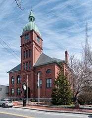 Town Hall
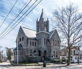 George Hail Public Library
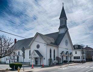 St. Jean Baptiste Church
%2C_Rhode_Island.jpg) Warren United Methodist Church and Civil War Memorial (Warren Common)
Warren United Methodist Church and Civil War Memorial (Warren Common)
Government
Warren is a part of the 10th District in the Rhode Island Senate and is currently represented by Democrat Walter Felag Jr. The town is a part of Rhode Island's 1st congressional district at the federal level and is presently represented by Democrat David Cicilline. It is a reliably Democratic stronghold in presidential elections, as no Republican has carried the town in over three decades.
| Year | GOP | DEM | Others |
|---|---|---|---|
| 2016 | 39.33% 1,987 | 53.15% 2,685 | 7.52% 380 |
| 2012 | 34.78% 1,688 | 63.01% 3,058 | 2.20% 107 |
| 2008 | 34.54% 1,760 | 63.85% 3,254 | 1.61% 82 |
| 2004 | 38.17% 1,835 | 59.93% 2,881 | 1.89% 91 |
| 2000 | 31.02% 1,446 | 62.74% 2,925 | 6.24% 291 |
| 1996 | 25.95% 1,177 | 60.79% 2,757 | 13.25% 601 |
| 1992 | 29.27% 1,544 | 46.03% 2,428 | 24.70% 1,303 |
| 1988 | 45.57% 2,120 | 54.02% 2,513 | 0.41% 19 |
Notable places
Notable people
- Lou Abbruzzi, NFL football player
- Pat Abbruzzi, All-Star Canadian football player, RI football legend
- F. Nelson Blount, Founder of the Blount Seafood Corporation and steam locomotive collector.
- Luther Blount, Started Blount Marine, American Canadian Caribbean Cruise Lines and Bay Queen Cruises
- Hezekiah Butterworth, was an American writer of books for young people, and a poet
- Jo-Jo Morrissey, infielder for the Cincinnati Reds and Chicago White Sox
- Elizabeth "Lizzie" Murphy “The Queen of Baseball” the first woman to play professional baseball competing with male athletes
References
- ↑ "US Board on Geographic Names". United States Geological Survey. 2007-10-25. Retrieved 2008-01-31.
- ↑ "Rhode Island History: Chapter 2". State of Rhode Island. Archived from the original on 19 September 2008. Retrieved 17 June 2016.
- ↑ "Annual Estimates of the Resident Population for Incorporated Places: April 1, 2010 to July 1, 2015". Retrieved July 2, 2016.
- ↑ "Census of Population and Housing". Census.gov. Archived from the original on May 12, 2015. Retrieved June 4, 2016.
- ↑ Snow, Edwin M. (1867). Report upon the Census of Rhode Island 1865. Providence, RI: Providence Press Company.
- ↑ "American FactFinder". United States Census Bureau. Archived from the original on 2013-09-11. Retrieved 2008-01-31.
- ↑ http://www.elections.state.ri.us/elections/preresults/
External links
| Wikivoyage has a travel guide for Warren (Rhode Island). |
Municipalities and communities of Bristol County, Rhode Island, United States | ||
|---|---|---|
| Towns | 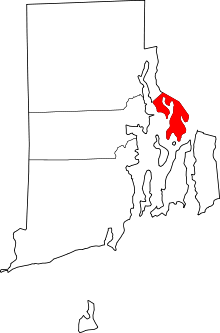 | |
Providence (capital) | |
| Topics |
|
| Society |
|
| Regions | |
| Cities | |
| Towns |
|
Coordinates: 41°43′49″N 71°16′57″W / 41.73028°N 71.28250°W