Trégourez
| Trégourez Tregoures | ||
|---|---|---|
| Commune | ||
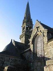 The parish church of Saint-Idunet | ||
| ||
 Trégourez Location within Brittany region  Trégourez | ||
| Coordinates: 48°06′23″N 3°51′42″W / 48.1064°N 3.8617°WCoordinates: 48°06′23″N 3°51′42″W / 48.1064°N 3.8617°W | ||
| Country | France | |
| Region | Brittany | |
| Department | Finistère | |
| Arrondissement | Châteaulin | |
| Canton | Briec | |
| Intercommunality | Haute Cornouaille | |
| Government | ||
| • Mayor (2014–2020) | Hervé Donnard | |
| Area1 | 17.72 km2 (6.84 sq mi) | |
| Population (2008)2 | 944 | |
| • Density | 53/km2 (140/sq mi) | |
| Time zone | UTC+1 (CET) | |
| • Summer (DST) | UTC+2 (CEST) | |
| INSEE/Postal code | 29291 /29970 | |
| Elevation | 85–227 m (279–745 ft) | |
|
1 French Land Register data, which excludes lakes, ponds, glaciers > 1 km2 (0.386 sq mi or 247 acres) and river estuaries. 2 Population without double counting: residents of multiple communes (e.g., students and military personnel) only counted once. | ||

Trégourez (Breton: Tregoures) is a commune in the Finistère department of Brittany in north-western France.
Population
Inhabitants of Trégourez are called in French Trégourézois.
| Year | 1793 | 1800 | 1806 | 1821 | 1831 | 1836 | 1841 | 1846 | 1851 | 1856 |
|---|---|---|---|---|---|---|---|---|---|---|
| Population | 891 | 948 | 920 | 1008 | 1058 | 1085 | 1074 | 1065 | 1081 | 1101 |
| Year | 1861 | 1866 | 1872 | 1876 | 1881 | 1886 | 1891 | 1896 | 1901 | 1906 |
|---|---|---|---|---|---|---|---|---|---|---|
| Population | 1115 | 1255 | 1122 | 1170 | 1190 | 1185 | 1255 | 1256 | 1292 | 1470 |
| Year | 1911 | 1921 | 1926 | 1931 | 1936 | 1946 | 1954 | 1962 | 1968 | 1975 |
|---|---|---|---|---|---|---|---|---|---|---|
| Population | 1502 | 1410 | 1336 | 1275 | 1313 | 1213 | 1129 | 1111 | 1004 | 921 |
| Year | 1982 | 1990 | 1999 | 2008 |
|---|---|---|---|---|
| Population | 878 | 939 | 949 | 944 |
See also
References
- Mayors of Finistère Association (in French)
External links
| Wikimedia Commons has media related to Trégourez. |
- Official website (in French)
- French Ministry of Culture list for Trégourez (in French)
This article is issued from
Wikipedia.
The text is licensed under Creative Commons - Attribution - Sharealike.
Additional terms may apply for the media files.