Loperhet
| Loperhet Loperc'hed | ||
|---|---|---|
| Commune | ||
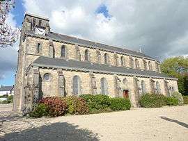 The parish church of Sainte-Brigitte | ||
| ||
 Loperhet Location within Brittany region  Loperhet | ||
| Coordinates: 48°22′32″N 4°18′14″W / 48.3756°N 4.3039°WCoordinates: 48°22′32″N 4°18′14″W / 48.3756°N 4.3039°W | ||
| Country | France | |
| Region | Brittany | |
| Department | Finistère | |
| Arrondissement | Brest | |
| Canton | Pont-de-Buis-lès-Quimerch | |
| Intercommunality | Pays de Landerneau-Daoulas | |
| Government | ||
| • Mayor (2014–2020) | Jean-Paul Morvan | |
| Area1 | 20.31 km2 (7.84 sq mi) | |
| Population (2008)2 | 3,558 | |
| • Density | 180/km2 (450/sq mi) | |
| Time zone | UTC+1 (CET) | |
| • Summer (DST) | UTC+2 (CEST) | |
| INSEE/Postal code | 29140 /29470 | |
| Elevation | 0–162 m (0–531 ft) | |
|
1 French Land Register data, which excludes lakes, ponds, glaciers > 1 km2 (0.386 sq mi or 247 acres) and river estuaries. 2 Population without double counting: residents of multiple communes (e.g., students and military personnel) only counted once. | ||
.svg.png)
Loperhet (Breton: Loperc'hed) is a commune in the Finistère department of Brittany in north-western France.
Population
Inhabitants of Loperhet are called in French Loperhétois.
| Historical population | ||
|---|---|---|
| Year | Pop. | ±% |
| 1962 | 1,280 | — |
| 1968 | 1,315 | +2.7% |
| 1975 | 1,411 | +7.3% |
| 1982 | 2,030 | +43.9% |
| 1990 | 2,941 | +44.9% |
| 1999 | 3,466 | +17.9% |
| 2008 | 3,558 | +2.7% |
Breton language
The municipality launched a linguistic plan through Ya d'ar brezhoneg on 22 October 2008.
In 2008, 14.56% of primary-school children attended bilingual schools.[1]
See also
References
- ↑ (in French) Ofis ar Brezhoneg: Enseignement bilingue
- Mayors of Finistère Association (in French);
External links
| Wikimedia Commons has media related to Loperhet. |
- Official website (in French)
- French Ministry of Culture list for Loperhet (in French)
This article is issued from
Wikipedia.
The text is licensed under Creative Commons - Attribution - Sharealike.
Additional terms may apply for the media files.