Plounévézel
| Plounévézel Plonevell | ||
|---|---|---|
| Commune | ||
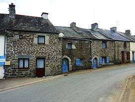 Old houses of Kergroas | ||
| ||
 Plounévézel Location within Brittany region  Plounévézel | ||
| Coordinates: 48°17′41″N 3°35′33″W / 48.2947°N 3.5925°WCoordinates: 48°17′41″N 3°35′33″W / 48.2947°N 3.5925°W | ||
| Country | France | |
| Region | Brittany | |
| Department | Finistère | |
| Arrondissement | Châteaulin | |
| Canton | Carhaix-Plouguer | |
| Intercommunality | Poher | |
| Government | ||
| • Mayor (2014–2020) | Xavier Berthou | |
| Area1 | 24.42 km2 (9.43 sq mi) | |
| Population (2008)2 | 1,122 | |
| • Density | 46/km2 (120/sq mi) | |
| Time zone | UTC+1 (CET) | |
| • Summer (DST) | UTC+2 (CEST) | |
| INSEE/Postal code | 29205 /29270 | |
| Elevation | 75–181 m (246–594 ft) | |
|
1 French Land Register data, which excludes lakes, ponds, glaciers > 1 km2 (0.386 sq mi or 247 acres) and river estuaries. 2 Population without double counting: residents of multiple communes (e.g., students and military personnel) only counted once. | ||
.svg.png)
Plounévézel (Breton: Plonevell) is a commune in the Finistère department of Brittany in north-western France.
Population
Inhabitants of Plounévézel are called in French Plounévézelois.
| Year | 1801 | 1821 | 1826 | 1831 | 1836 | 1841 | 1846 | 1851 | 1856 | 1861 |
|---|---|---|---|---|---|---|---|---|---|---|
| Population | 958 | 855 | 920 | 975 | 1076 | 1041 | 1070 | 1072 | 1024 | 1030 |
| Year | 1866 | 1872 | 1876 | 1881 | 1886 | 1891 | 1896 | 1901 | 1906 | 1911 |
|---|---|---|---|---|---|---|---|---|---|---|
| Population | 988 | 1039 | 1074 | 1081 | 1111 | 1254 | 1284 | 1299 | 1269 | 1259 |
| Year | 1921 | 1926 | 1931 | 1936 | 1946 | 1954 | 1962 | 1968 | 1975 | 1982 |
|---|---|---|---|---|---|---|---|---|---|---|
| Population | 1298 | 1201 | 1098 | 1018 | 1007 | 845 | 760 | 658 | 714 | 829 |
| Year | 1990 | 1999 | 2008 |
|---|---|---|---|
| Population | 1017 | 1015 | 1122 |
See also
References
- Mayors of Finistère Association (in French)
External links
| Wikimedia Commons has media related to Plounévézel. |
- Official website (in French)
- French Ministry of Culture list for Plounévézel (in French)
This article is issued from
Wikipedia.
The text is licensed under Creative Commons - Attribution - Sharealike.
Additional terms may apply for the media files.