Argol, Finistère
| Argol Argol | ||
|---|---|---|
| Commune | ||
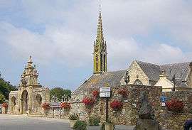 Town square and parish church | ||
| ||
 Argol Location within Brittany region  Argol | ||
| Coordinates: 48°14′47″N 4°18′55″W / 48.2464°N 4.3153°WCoordinates: 48°14′47″N 4°18′55″W / 48.2464°N 4.3153°W | ||
| Country | France | |
| Region | Brittany | |
| Department | Finistère | |
| Arrondissement | Châteaulin | |
| Canton | Crozon | |
| Intercommunality | CC Presqu'île Crozon-Aulne Maritime | |
| Government | ||
| • Mayor (2014-2020) | Henri Le Pape | |
| Area1 | 31.73 km2 (12.25 sq mi) | |
| Population (2015)2 | 1,030 | |
| • Density | 32/km2 (84/sq mi) | |
| Time zone | UTC+1 (CET) | |
| • Summer (DST) | UTC+2 (CEST) | |
| INSEE/Postal code | 29001 /29560 | |
|
1 French Land Register data, which excludes lakes, ponds, glaciers > 1 km2 (0.386 sq mi or 247 acres) and river estuaries. 2 Population without double counting: residents of multiple communes (e.g., students and military personnel) only counted once. | ||

Argol (Breton: Argol) is a commune in the Finistère department and administrative region of Brittany in north-western France.
Population
In French the inhabitants of Argol are known as Argoliens.
| Historical population | ||
|---|---|---|
| Year | Pop. | ±% |
| 1793 | 843 | — |
| 1800 | 544 | −35.5% |
| 1806 | 731 | +34.4% |
| 1821 | 1,013 | +38.6% |
| 1831 | 1,132 | +11.7% |
| 1836 | 1,223 | +8.0% |
| 1841 | 1,275 | +4.3% |
| 1846 | 1,325 | +3.9% |
| 1851 | 1,366 | +3.1% |
| 1856 | 1,352 | −1.0% |
| 1861 | 1,393 | +3.0% |
| 1866 | 1,383 | −0.7% |
| 1872 | 1,363 | −1.4% |
| 1876 | 1,366 | +0.2% |
| 1881 | 1,353 | −1.0% |
| 1886 | 1,357 | +0.3% |
| 1891 | 1,435 | +5.7% |
| 1896 | 1,441 | +0.4% |
| 1901 | 1,485 | +3.1% |
| 1906 | 1,455 | −2.0% |
| 1911 | 1,499 | +3.0% |
| 1921 | 1,283 | −14.4% |
| 1926 | 1,311 | +2.2% |
| 1931 | 1,232 | −6.0% |
| 1936 | 1,181 | −4.1% |
| 1946 | 1,095 | −7.3% |
| 1954 | 984 | −10.1% |
| 1962 | 899 | −8.6% |
| 1968 | 819 | −8.9% |
| 1975 | 766 | −6.5% |
| 1982 | 700 | −8.6% |
| 1990 | 698 | −0.3% |
| 1999 | 746 | +6.9% |
| 2007 | 802 | +7.5% |
| 2013 | 1,023 | +27.6% |
| 2015 | 1,030 | +0.7% |
See also
References
- Mayors of Finistère Association (in French);
External links
| Wikimedia Commons has media related to Argol. |
This article is issued from
Wikipedia.
The text is licensed under Creative Commons - Attribution - Sharealike.
Additional terms may apply for the media files.