Telgruc-sur-Mer
| Telgruc-sur-Mer Terrug | ||
|---|---|---|
| Commune | ||
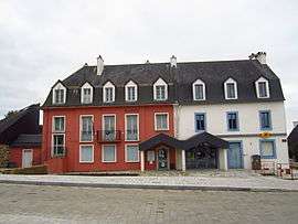 The town hall in Telgruc-sur-Mer | ||
| ||
 Telgruc-sur-Mer Location within Brittany region  Telgruc-sur-Mer | ||
| Coordinates: 48°13′57″N 4°21′18″W / 48.2325°N 4.3550°WCoordinates: 48°13′57″N 4°21′18″W / 48.2325°N 4.3550°W | ||
| Country | France | |
| Region | Brittany | |
| Department | Finistère | |
| Arrondissement | Châteaulin | |
| Canton | Crozon | |
| Intercommunality | Presqu'île de Crozon | |
| Government | ||
| • Mayor (2014–2020) | Dominique Le Pennec | |
| Area1 | 28.29 km2 (10.92 sq mi) | |
| Population (2008)2 | 2,042 | |
| • Density | 72/km2 (190/sq mi) | |
| Time zone | UTC+1 (CET) | |
| • Summer (DST) | UTC+2 (CEST) | |
| INSEE/Postal code | 29280 /29560 | |
| Elevation | 0–145 m (0–476 ft) | |
|
1 French Land Register data, which excludes lakes, ponds, glaciers > 1 km2 (0.386 sq mi or 247 acres) and river estuaries. 2 Population without double counting: residents of multiple communes (e.g., students and military personnel) only counted once. | ||
.svg.png)
Telgruc-sur-Mer (Breton: Terrug) is a commune in the Finistère department of Brittany in north-western France.
Population
Inhabitants of Telgruc-sur-Mer are called in French Telgruciens.
See also
References
- Mayors of Finistère Association (in French)
External links
| Wikimedia Commons has media related to Telgruc-sur-Mer. |
- Official website (in French)
- French Ministry of Culture list for Telgruc-sur-Mer (in French)
This article is issued from
Wikipedia.
The text is licensed under Creative Commons - Attribution - Sharealike.
Additional terms may apply for the media files.